Description
This is a Slow Ways route connecting Stevenage and Baldock.
Know of a better route? Share it here.
This is a Slow Ways route connecting Stevenage and Baldock.
Know of a better route? Share it here.
Status
This route has been reviewed by 3 people.
There are no issues flagged.
Photos for Stebal one

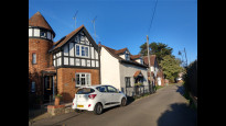

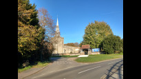
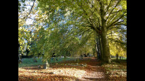


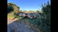
Photos of this route will appear when they are added to a review. You can review this route here.
Information
")
Route status - Live
Reviews - 3
Average rating -
Is this route good enough? - Yes (3)
There are currently no problems reported with this route.
Downloads - 6
Surveys
What is this route like?
Surveys are submitted by fellow users of this website and show what you might expect from this Slow Ways route. Scroll down the page to read more detailed surveys.
| Grade 3X based on 1 surveys | Sign up or log in to survey this route. | ||
|---|---|---|---|
| Description | Note | ||
| Grade 3: Route includes rough surfaces that may include small boulders, potholes, shallow ruts, loose gravel, short muddy sections. Access grade X: At least one stile, flight of steps or other obstacle that is highly likely to block access for wheelchair and scooter users. |
Grading is based on average scores by surveyors. This slow way has 1 surveys. | ||
| Full grading description | |||
Only people who have completed our training can become Slow Ways surveyors and submit a survey. We do not vet contributors, so we cannot guarantee the quality or completeness of the surveys they complete. If you are dependent on the information being correct we recommend reading and comparing surveys before setting off.
Survey Photos
Facilities
Facilities in the middle third of this route.
Challenges
Potential challenges reported on this route. Some challenges are seasonal.
Obstacles
Obstacles on this route.
Accessibility
Is this route step and stile free?
Measurements
Surveyors were asked to measure the narrowest and steepest parts of paths.
Narrowest part of path: no data
The steepest uphill gradient East: no data
The steepest uphill gradient West: no data
The steepest camber: no data
How clear is the waymarking on the route: Clear (1)
Successfully completed
We asked route surveyors "Have you successfully completed this route with any of the following? If so, would you recommend it to someone with the same requirements?". Here is how they replied.
Recommended by an expert
We asked route surveyors "Are you a trained access professional, officer or expert? If so, is this route suitable for someone travelling with any of the following?" Here is how they replied.
Terrain
We asked route surveyors to estimate how much of the route goes through different kinds of terrain.
25.0% of the route is on roads (1)
20.0% of the route is lit at night (1)
20.0% of the route is paved (1)
40.0% of the route is muddy (1)
25.0% of the route is over rough ground (1)
10.0% of the route is through long grass (1)
Report a problem with this data
1 surveys
Information from verified surveys.
Geography information system (GIS) data
Total length
Maximum elevation
Minimum elevation
Start and end points
Stevenage
Grid Ref
TL2348324087
Lat / Lon
51.90166° / -0.20658°
Easting / Northing
523,483E / 224,087N
What3Words
faded.pushed.behind
Baldock
Grid Ref
TL2447033888
Lat / Lon
51.98952° / -0.18869°
Easting / Northing
524,470E / 233,888N
What3Words
united.farms.shaky
Stebal One's land is
| Stevenage | |
|---|---|
| Grid Ref | TL2348324087 |
| Lat / Lon | 51.90166° / -0.20658° |
| Easting / Northing | 523,483E / 224,087N |
| What3Words | faded.pushed.behind |
| Baldock | |
|---|---|
| Grid Ref | TL2447033888 |
| Lat / Lon | 51.98952° / -0.18869° |
| Easting / Northing | 524,470E / 233,888N |
| What3Words | united.farms.shaky |
| Arable | 44.7% |
| Green urban | 9.5% |
| Pasture | 10.6% |
| Urban | 35.2% |
Data: Corine Land Cover (CLC) 2018
reviews
Greysquirrel
12 Nov 2022Good route, footpaths and some urban pavements mostly, small amount on country roads without pavement, bit not too much. Some lovely views around Weston in particular. I followed the route in November on sunny day after quite a lot of rain, and surprisingly it wasn't too muddy. Some steps onto bridges over roads at Stevenage end, some with ramps though, and otherwise fairly flat.
LukeMorgan
08 Oct 2022A pleasant enough walk, particularly once you leave the concrete of Stevenage and rapidly find yourself crossing rolling fields. There's a mixture of walking along pavements, country roads, and muddy paths with some beautiful views.
-
Share your thoughts
Anne Holland
06 Jun 2022This was an easy to follow, very pleasant walk. A direct route out of Stevenage and through lovely, gently rolling countryside to Weston and then to Baldock. Most of it very rural, on footpaths and bridleways, some on country lanes with no pavement.
-
Share your thoughts
Share your views about this route, give it a star rating, indicate whether it should be verified or not.
Include information that will be useful to others considering to walk or wheel it.
You can add up to 15 photos.
Other Routes for Stevenage—Baldock See all Slow Ways
Review this better route and help establish a trusted network of walking routes.
Suggest a better route if it better meets our methodology.
Share your thoughts