Frequently Asked Questions are listed here, with brief Frequent Answers. For Infrequently Asked Questions, or to delve into some of the queries and FAQ content below, use this Zendesk link for interaction and answers. Please note Zendesk is a separate platform to the main Slow Ways site so will require creating a different account to post and answer questions. Once in the Forum please use the sign up or sign in function in the top right hand corner.
What is the Slow Ways initiative?
Is information about accessibility be included?
Can a local council or authority show their support?
Great Britain already has lots of paths. What does this add?
How were Slow Ways destinations decided
How are Slow Ways routes decided?
How is Ordnance Survey involved?
What does the Slow Ways website do?
Will Slow Ways route information be available under a Creative Commons license?
Who’s behind the Slow Ways initiative?
What is the Slow Ways initiative?
Slow Ways a national network of walking routes connecting all of Great Britain’s towns and cities as well as thousands of villages.
It’s helping to get more people walking, further, more often, for more reasons and purposes.
Slow Ways can be a way of thinking, seeing, planning, navigating, exploring, learning, caring, creating, collaborating, connecting, campaigning and sharing…all by going for a walk.
What is a Slow Way?
A Slow Way is a route for walking, or wheeling, between two places – neighbouring cities, towns and villages – using a wide variety of existing paths, ways, trails and roads.
Their key principle is that people should be able to walk reasonably directly, safely, easily and enjoyably between neighbouring settlements. There may be more than one Slow Ways route option between two locations.
How long are Slow Ways routes?
The average Slow Way is 14.7km. Hundreds are around 5km long, and thousands are under 10km.
Their length is determined by factors such as local landscape, path options, distances between settlements and a route-planning methodology.
Where are Slow Ways routes?
All over Great Britain – from Shetland to Cornwall! One million people live within 500 metres of a Slow Way. The next stage of development is to cover the whole of the UK and Ireland.

Who uses Slow Ways, and why?
Slow Ways can be used by anyone able to walk or wheel from A to B. They can use the website to view routes mapped by volunteers, and browse a range of information (including user-created reviews and surveys) to gauge route suitability.
Slow Ways routes aren’t just for recreational walkers – a full cross-section of society use them, for a wide range of purposes.
Slow Ways routes are used to see family, meet friends, get to work, walk to an event, or go on adventures.
They can be used to walk short distances between neighbouring locations, and combined to create longer distance journeys.
It’s a positive, timely, and important initiative. Walking can improve health and wellbeing, be part of lifestyle changes that help tackle the climate and ecological emergencies, save people money, help make nature connections, and bring joy to people’s lives.
Slow Ways will make it easier for people to see, imagine, plan, enjoy and share journeys on foot.
Is Slow Ways free?
Yes. You’ll always be able to search, browse, review and download information about Slow Ways for free. They are mapped using existing paths, ways and trails that are free to use.
Will information about accessibility be included?
Yes. Each Slow Ways route page includes user-created reviews, photos and surveys with information about obstacles and the nature of paths. This is a work-in-progress throughout 2021 as this content is created – please bear with us.
Please see Route Information, Grades and Access, and our Accessibility Statement.
Do I need training?
No. The Slow Ways website should give you all the information you need to search for Slow Ways, find out about them and contribute reviews.
There are specific requirements for submitting route surveys which needs self-confirmation that online guidance has been read and understood.
And there is ongoing information-sharing – through webinars, Zendesk and social media – to introduce and share different aspects of Slow Ways.
How can I get involved?
The 7,000+ walking routes that created the ‘first draft’ of the Slow Ways network were mapped by volunteers. Slow Ways is a grassroots initiative reliant on user contributions.
The invitation in 2021 is to help walk and review all 100,000km+ of the Slow Ways routes that have been drafted. That’s the equivalent of walking 2.5 times around the equator. Shared between 10,000 contributors – individuals, established groups, new groups and collaborators – that’s an average of just 10km each.
This will help establish a trusted, credible and user-verified network of Slow Ways routes as a means of making walking journeys between all of Great Britain’s towns and cities and many more places too.
You can get involved by walking and reviewing (as well as rating, verifying, and surveying) one or more Slow Ways routes.
There’s much more information on our Get Involved pages.
And just sign up to receive updates about Slow Ways.
Can groups get involved?
Yes! You can sign up to register a group’s interest. Find out more about how groups can use and contribute to Slow Ways and make them part of a group’s own activities.
Can a local council or authority show their support?
Yes! Support from Town Councils, Community & Parish Councils, Local Authorities and Protected Areas is invited, welcomed and encouraged. This can involve:
- Passing a formal motion (or declaration, concordat etc.) of support.
- Promoting Slow Ways for local residents to walk, review and use routes.
- Including Slow Ways within planning, policies and initiatives.
- Considering where new paths might strengthen the Slow Ways network.
- Encouraging representatives to sign-up personally to walk and review a Slow Way.
A template report can be adapted to help with this.
Great Britain already has lots of paths. What does this add?
Yes, that’s true, but they don’t form a coherent and comprehensive country-wide network. Slow Ways walking routes – drafted by volunteers and reviewed by people using them – suggest ways to walk and wheel between all the neighbouring towns, cities and villages across Great Britain.
This distinctive Slow Ways geometric mapping, and the highlighting of route options, makes it easier to see and plan journeys. As well as linking towns and cities that have lots of places to eat, sleep and rest, it encourages longer distance journeys by linking multiple Slow Ways routes.
How were the Slow Way’s destinations decided?
Slow Ways routes always link two primary settlements. There are about 2,500 of these in the Slow Ways network of walking routes, selected because of their population size or their cultural, transport or local importance. Many were based on the ‘primary destinations’ and ‘primary locations’ identified by the Department for Transport and Ordnance Survey.
Slow Ways is primarily an inter-town and inter-city network. While cities have multiple Slow Ways destinations within them, one of the network’s strengths is in the routes that radiate out to connect thousands more hamlets, villages and suburbs that are not primary destinations.
How are Slow Ways routes decided?
A small team of volunteers created an overview plan of all the towns and cities to be included in the Slow Ways network, and which neighbouring settlements should be connected. This resulted in the distinctive triangular shapes that you can see in Slow Ways maps.
700 volunteers, with basic training in the use of OS Maps, drafted the first network of Slow Ways routes during the Spring 2020 lockdown. Routes were designed, as far as possible, to follow this methodology:
1. be safe
2. respect local codes and laws
3. be accessible to as many people as possible
4. be direct
5. be off road
6. have resting places to eat or sleep every 5-10km
7. pass through train and bus stations
8. be easy to navigate
9. be enjoyable and beautiful
10. use established routes (such as the Welsh Coast Path), but not be distracted by them!
Routes must start and finish at a designated location identified in the centre of the villages, towns or cities that are being connected.
Some routes need to use roads, and in many parts of the country there isn’t a ‘resting place’ every 10km.
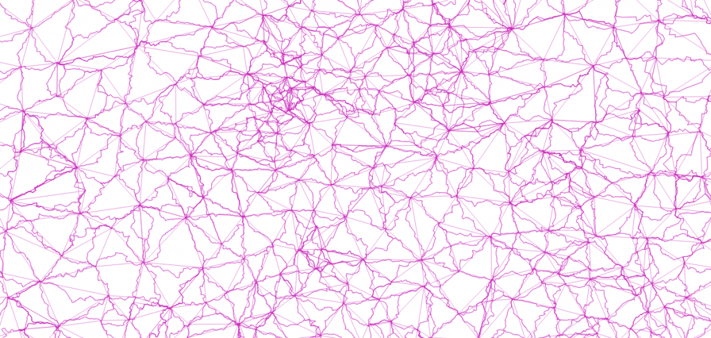
This map shows the structure of the network. The straight lines show Slow Ways as the crow flies and aren’t meant to be walkable.
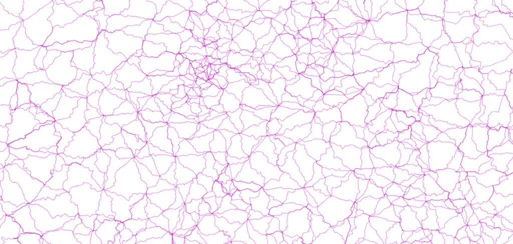
These wiggly lines show Slow Ways routes in the West Midlands. Some are more direct than others, and show how easy it is to follow one or more and to join them up to create longer journeys.
How are Slow Ways named?
Every Slow Ways route has its own name, created by joining the first three letters of the two neighbouring places they connect. The place and names are always arranged from west to east. This results in hundreds of quirky, charming and memorable names.
The route from Beaconsfield to Slough is called Beaslo, for example. Alternative route options are named in the order they are submitted, going from Beaslo one and Beaslo two to Beaslo three etc.
Each Slow Ways route option also has a unique code that is simply a number.
How is Ordnance Survey involved?
The OS Maps platform has been used to collaboratively create all the Slow Ways routes we’ve made so far. The whole Slow Ways network of routes will be published to the OS Maps web platform.
A blog about Slow Ways was amongst the most popular on the Ordnance Survey website in 2020.
Maybe in the future Slow Ways routes will feature on Ordnance Survey paper maps? It’s a great thing to work towards.
What does the Slow Ways website do?
As well as being used to search for, browse, download and print Slow Ways routes, it’s where users can review, rate, verify, and comment on them too. It’s a place to collect and share stories, films, and all kinds of creative interpretations of Slow Ways.
Website design includes considerations for the visually impaired and an awareness of requirements of a range of users. We’ll be asking for feedback and further guidance with a view to making improvements in the next release of the site. It’s designed to AA web standards, with awareness of colourblind issues, and currently rates 100/100 on the Google Siteimprove Accessibility Checker.
Can runners use Slow Ways?
Yes.
Will Slow Ways route information be available under a Creative Commons license?
All words and images you share with Slow Ways are licensed to us and others under a Creative Commons Attribution-ShareAlike 4.0 license (CC BY-SA 4.0).
Currently you can only use Slow Ways route data (.GPX files) for personal and non-commercial use. They are currently protected by © Crown Copyright / Ordnance Survey. We hope that will change in the near future.
We are working towards future versions of the verified Slow Ways network being licensed under the Open Data Commons Open Database License (ODbL).
For more details see our terms and conditions.
Who’s behind the Slow Ways initiative?
Slow Ways was started by Dan Raven-Ellison. Dan’s done lots of walking in the UK and began wondering why our incredible footpath infrastructure, heritage and culture is not better organised and easier to navigate.
In February 2020 Dan invited anyone who likes maps and walking to attend a Slow Ways hackday at GeoVation, Ordnance Survey’s innovation centre in central London. The day was full of learning, energy and success. As a result, the idea of Slow Ways started to grow.
Dan had planned to organise ten further hack events across Wales, Scotland and England to complete a first draft of the Slow Ways network. Unfortunately Covid-19 put the brakes on that.
A call was put out for anyone to attend online training (by Zoom of course) to help create the network and 700 people stepped forward. As a result of their enthusiasm, creativity, determination and energy, roughly a year’s worth of time was invested in the project in a single month. The result was a first initial draft of the Slow Ways network.
The Slow Ways initiative would not exist if it was not for the positivity and generosity of the people who have volunteered so far. Thank you!
We now need to recruit thousands of people from across Great Britain to help walk, test, verify, record, improve and enjoy the Slow Ways walking routes. To do that we’re building a website to host information on all of the routes and doing lots of work to make sure the project is a success.
To help with all of that, we’ve recently set up Slow Ways CIC. This is a not-for-profit and asset locked Community Interest Company that is limited by guarantee. It’s purpose is to help make the Slow Ways initiative a success and as a result, get more people walking more of the time.
The initiative has been supported by friends at OnePointFive, Urban Good, Ordnance Survey, OS Maps and ESRI and Rob Bushby Consulting.
Slow Ways has had critical funding from Sport England & The National Lottery, Paths for All, The Pilgrim Trust and Kestrelman Trust.
Thank you to everyone who has contributed so far.