Lightwater — Ottershaw
Ligott three

Slow Way not verified yet. Verify Ligott here.
Slow Way not verified yet. Verify Ligott here.
By Petr Sadilek on 28 Jul 2023
Description
The third proposed route aspires to eliminate some drawbacks of Ligott one and two. First, it avoid the problematic section between Philpot lane and Youngstroat Lane which is almost impassible. It also avoid walking long distances on busy roads and takes a shortcut close to Ottershaw where the route approaches Paragon Roundabout.
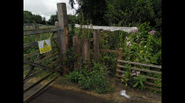
Walkers should be mindful when approaching the Broadoak farm that a public footpath by-passing the farm leads right next to the gate to the farm and it is quite overgrown. See a photo below
The third proposed route aspires to eliminate some drawbacks of Ligott one and two. First, it avoid the problematic section between Philpot lane and Youngstroat Lane which is almost impassible. It also avoid walking long distances on busy roads and takes a shortcut close to Ottershaw where the route approaches Paragon Roundabout.
Walkers should be mindful when approaching the Broadoak farm that a public footpath by-passing the farm leads right next to the gate to the farm and it is quite overgrown. See a photo below
Status
This route has been reviewed by 1 person.
There are no issues flagged.
Photos for Ligott three
Photos of this route will appear when they are added to a review. You can review this route here.
Information
Route status - Live
Reviews - 1
Average rating -
Is this route good enough? - Yes (1)
There are currently no problems reported with this route.
Downloads - 1
Surveys
We are working to build-up a picture of what routes look like. To do that we are asking volunteers to survey routes so that we can communicate features, obstacles and challenges that may make a route desirable or not.
Slow Ways surveyors are asked to complete some basic online training, but they are not vetted. If you are dependent on the survey information being correct in order to complete a route, we recommend that you think critically about the information provided. You may also wish to wait until more than one survey has been completed.
Help people know more about this route by volunteering to submit a survey.
- Complete the survey training.
- Submit a survey for this route.
Geography information system (GIS) data
Total length
Maximum elevation
Minimum elevation
Start and end points
Lightwater
Grid Ref
SU9311462156
Lat / Lon
51.35086° / -0.66429°
Easting / Northing
493,114E / 162,156N
What3Words
lights.hint.crass
Ottershaw
Grid Ref
TQ0233863935
Lat / Lon
51.36527° / -0.53137°
Easting / Northing
502,338E / 163,935N
What3Words
trash.pans.fork
| Lightwater | |
|---|---|
| Grid Ref | SU9311462156 |
| Lat / Lon | 51.35086° / -0.66429° |
| Easting / Northing | 493,114E / 162,156N |
| What3Words | lights.hint.crass |
| Ottershaw | |
|---|---|
| Grid Ref | TQ0233863935 |
| Lat / Lon | 51.36527° / -0.53137° |
| Easting / Northing | 502,338E / 163,935N |
| What3Words | trash.pans.fork |
Sorry Land Cover data is not currently available for this route. Please check back later.
Other Routes for Lightwater—Ottershaw See all Slow Ways
Review this better route and help establish a trusted network of walking routes.
Suggest a better route if it better meets our methodology.