Description
This is a Slow Ways route connecting Horndean and Petersfield.
Know of a better route? Share it here.
This is a Slow Ways route connecting Horndean and Petersfield.
Know of a better route? Share it here.
Status
This route has been reviewed by 3 people.
There are no issues flagged.
Photos for Horpet one


Photos of this route will appear when they are added to a review. You can review this route here.
Information
")
Route status - Live
Reviews - 3
Average rating -
Is this route good enough? - Yes (3)
There are currently no problems reported with this route.
Downloads - 10
Surveys
We are working to build-up a picture of what routes look like. To do that we are asking volunteers to survey routes so that we can communicate features, obstacles and challenges that may make a route desirable or not.
Slow Ways surveyors are asked to complete some basic online training, but they are not vetted. If you are dependent on the survey information being correct in order to complete a route, we recommend that you think critically about the information provided. You may also wish to wait until more than one survey has been completed.
Help people know more about this route by volunteering to submit a survey.
- Complete the survey training.
- Submit a survey for this route.
Geography information system (GIS) data
Total length
Maximum elevation
Minimum elevation
Start and end points
Horndean
Grid Ref
SU7066113148
Lat / Lon
50.91347° / -0.99624°
Easting / Northing
470,661E / 113,148N
What3Words
ribcage.blossom.mountain
Petersfield
Grid Ref
SU7461523286
Lat / Lon
51.00413° / -0.93793°
Easting / Northing
474,615E / 123,286N
What3Words
firewall.listen.clipped
Horpet One's land is
| Horndean | |
|---|---|
| Grid Ref | SU7066113148 |
| Lat / Lon | 50.91347° / -0.99624° |
| Easting / Northing | 470,661E / 113,148N |
| What3Words | ribcage.blossom.mountain |
| Petersfield | |
|---|---|
| Grid Ref | SU7461523286 |
| Lat / Lon | 51.00413° / -0.93793° |
| Easting / Northing | 474,615E / 123,286N |
| What3Words | firewall.listen.clipped |
| Arable | 38.5% |
| Pasture | 29.3% |
| Urban | 9.1% |
| Woods | 23.1% |
Data: Corine Land Cover (CLC) 2018
reviews
Stuart Hall
24 Jul 2023Walked from Petersfield to Horndean. Initial route along roads but once you leave the mobile home park off The Causeway it was a lovely walk on a sunny and not too hot July day. The stretch from Petersfield to Buriton would likely be pretty muddy in winter.
From Buriton to Horndean included lovely views and other than a bit of a pull up slopes in QE Park and towards the end was not particularly strenuous. The Red Lion at Chalton provides an excellent spot for a drink along the way.
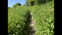
Slightly overgrown paths towards Horndean but no significant battles against brambles, thistles and nettles.
Once I arrived in Horndean I carried on to Rowlands Castle and caught the train back to Petersfield.
Mtormey
30 May 2023I walked this route from Petersfield to Horndean. It's an excellent walk I enjoyed quite a bit.
The bit through Petersfield is fine and safe, if a bit car-y along The Causeway especially. When I walked there was a market on, so much of the town centre was pedestrianised.
Very quickly, the route gets out into open countryside, where the paths wind their way through rolling hills and valleys, all green and lush when I walked in May. The walk through Queen Elizabeth Country Park was lovely, and Chalton Down was a special highlight. The final mile or so into Horndean felt a bit of a slog, but the walking was fine - I was probably just getting tired!
The route is beautiful and green, with lots of small discoveries to be made along the way. Navigation is easy, even where the plotting is a bit imprecise. There are a couple of climbs, but none too steep or aggressive, I found. The previous reviewer noted everything I might want to say, I think, except I'd note that, while a lot of the route is exposed, a lot of it is covered, too. A nice balance on a not-terribly-hot and breezy day, maybe less pleasant on a very hot day.
Horndean wasn't all that interesting, but I stopped at one of the pubs by the node and kept going to Emsworth. I really enjoyed this route, and I hope the pictures give a sense of how beautiful it is!.
-
Share your thoughts
Penny
09 Oct 2022I really enjoyed this run. It was quite hilly in places as you'd expect in this area but the Staunton Way was well maintained and the rest of the route was well sign posted.
It's quite an exposed route so I wouldn't want to do it if it was very wet or hot, but on a sunny October morning it was glorious.
People on wheels will find the first section difficult as there are many stiles between the fields (gates once you get past Wick Hanger), and in places the flints are very loose under foot which made running difficult.
I imagine it would get quite muddy in places in the winter or with a lot of rain, but wasn't too bad today.
Although a few bits are on road, most was on trail which was great except for a few overgrown bits - got nettles on the ankle.
You should be able to get food and drink in both Horndean and Petersfield, but there wasn't much on route. There is a cafe in Queen Elizabeth Country Park, but the route didn't go near it, you'd have to go looking for it.
On the hills I watched and heard larks.
And at Buriton I stopped to watch a kingfisher fishing in the village pond.
I look forward to doing this one again.
-
Share your thoughts
Share your views about this route, give it a star rating, indicate whether it should be verified or not.
Include information that will be useful to others considering to walk or wheel it.
You can add up to 15 photos.
There are no other routes for Horndean — Petersfield
If you know a better way, then please let us know.
Review this better route and help establish a trusted network of walking routes.
Suggest a better route if it better meets our methodology.
Share your thoughts