Description
This is a Slow Ways route connecting Ebbw Vale and Blaina.
Know of a better route? Share it here.
This is a Slow Ways route connecting Ebbw Vale and Blaina.
Know of a better route? Share it here.
Status
This route has been reviewed by 2 people.
This route has been flagged (2 times) for reasons relating to access.
Photos for Ebbbla one


Photos of this route will appear when they are added to a review. You can review this route here.
Information

Route status - Live
Reviews - 2
Average rating -
Is this route good enough? - Maybe (2)
Problems reported - Access (2)
Downloads - 0
Surveys
We are working to build-up a picture of what routes look like. To do that we are asking volunteers to survey routes so that we can communicate features, obstacles and challenges that may make a route desirable or not.
Slow Ways surveyors are asked to complete some basic online training, but they are not vetted. If you are dependent on the survey information being correct in order to complete a route, we recommend that you think critically about the information provided. You may also wish to wait until more than one survey has been completed.
Help people know more about this route by volunteering to submit a survey.
- Complete the survey training.
- Submit a survey for this route.
Geography information system (GIS) data
Total length
Maximum elevation
Minimum elevation
Start and end points
Ebbw Vale
Grid Ref
SO1676109470
Lat / Lon
51.77769° / -3.20793°
Easting / Northing
316,761E / 209,470N
What3Words
scale.learn.zooms
Blaina
Grid Ref
SO2005407881
Lat / Lon
51.76388° / -3.15984°
Easting / Northing
320,054E / 207,881N
What3Words
river.tucked.mailing
Ebbbla One's land is
| Ebbw Vale | |
|---|---|
| Grid Ref | SO1676109470 |
| Lat / Lon | 51.77769° / -3.20793° |
| Easting / Northing | 316,761E / 209,470N |
| What3Words | scale.learn.zooms |
| Blaina | |
|---|---|
| Grid Ref | SO2005407881 |
| Lat / Lon | 51.76388° / -3.15984° |
| Easting / Northing | 320,054E / 207,881N |
| What3Words | river.tucked.mailing |
| Natural grass | 60.6% |
| Urban | 39.4% |
Data: Corine Land Cover (CLC) 2018
reviews
Paul Chilcott
11 Dec 2023December 2023. Direction: Blaina to Ebbw Vale.
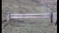
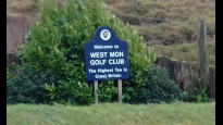
A relatively easy walk over the mountain from Blaina to Ebbw Vale in the next valley. The path leaving Inkerman Row, near Tir Watkin appears to go straight through the wood, which is a complete tangle. This was also a problem in the Nantyglo to Blaina Slow Way (Nanbla1). Previously, it was almost impassable. This time it seemed a little easier, maybe because of one of the wood`s inhabitants (Photo 1). An easier route would be to go straight up the hill by the side of this wood and turn right on to the track at the top, which runs down to the other end of the wood, but it may not be a right of way. The only other access issue was the fence just past Chapelhouse (photo 3), but it is easy to cross over or under it (not really much of a fence). The route then takes you on to the open moor and then along the top end of the West Mon golf course, passing the highest golf tee in the UK according to the Guinness Book Of Records (Photo 4). From there it`s downhill all the way. The path takes a bit of a detour to the right ad then back compared with the OS right of way.
Photo 1 - Inhabitant of the wood just above Tir Watkin
Photo 2 - Pond between Tir Watkin and Chapelhouse
Photo 3 - Fence just above Chapelhouse
Photo 4 - West Mon Golf Course.
Tim Ryan
29 Apr 2022A nice walk once you are on the open access area above the golf course. However I found access issues when climbing out of Blaina. There is no signage and some boundary crossings were fenced off. Climbing of gates and fences was involved near Tir Watkin and Chaplehouse, which ruins an otherwise lovely route.
-
Share your thoughts
Share your views about this route, give it a star rating, indicate whether it should be verified or not.
Include information that will be useful to others considering to walk or wheel it.
You can add up to 15 photos.
There are no other routes for Ebbw Vale — Blaina
If you know a better way, then please let us know.
Review this better route and help establish a trusted network of walking routes.
Suggest a better route if it better meets our methodology.
Share your thoughts