Description
This is a Slow Ways route connecting Dover and Deal.
Know of a better route? Share it here.
This is a Slow Ways route connecting Dover and Deal.
Know of a better route? Share it here.
Status
This route has been reviewed by 3 people.
There are no issues flagged.
Photos for Dovdea one


Photos of this route will appear when they are added to a review. You can review this route here.
Information
")
Route status - Live
Reviews - 3
Average rating -
Is this route good enough? - Yes (3)
There are currently no problems reported with this route.
Downloads - 10
Surveys
We are working to build-up a picture of what routes look like. To do that we are asking volunteers to survey routes so that we can communicate features, obstacles and challenges that may make a route desirable or not.
Slow Ways surveyors are asked to complete some basic online training, but they are not vetted. If you are dependent on the survey information being correct in order to complete a route, we recommend that you think critically about the information provided. You may also wish to wait until more than one survey has been completed.
Help people know more about this route by volunteering to submit a survey.
- Complete the survey training.
- Submit a survey for this route.
Geography information system (GIS) data
Total length
Maximum elevation
Minimum elevation
Start and end points
Dover
Grid Ref
TR3138641475
Lat / Lon
51.12580° / 1.30542°
Easting / Northing
631,386E / 141,475N
What3Words
wins.update.stop
Deal
Grid Ref
TR3742552596
Lat / Lon
51.22316° / 1.39890°
Easting / Northing
637,425E / 152,596N
What3Words
slate.silly.part
Dovdea One's land is
| Dover | |
|---|---|
| Grid Ref | TR3138641475 |
| Lat / Lon | 51.12580° / 1.30542° |
| Easting / Northing | 631,386E / 141,475N |
| What3Words | wins.update.stop |
| Deal | |
|---|---|
| Grid Ref | TR3742552596 |
| Lat / Lon | 51.22316° / 1.39890° |
| Easting / Northing | 637,425E / 152,596N |
| What3Words | slate.silly.part |
| Arable | 24.7% |
| Coast | 0.0% |
| Intertidal flats | 23.1% |
| Pasture | 3.9% |
| Urban | 47.9% |
| Woods | 0.3% |
Data: Corine Land Cover (CLC) 2018
reviews
Andrew
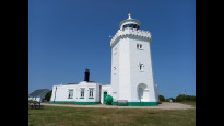
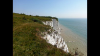
19 Aug 2023This is a very enjoyable and interesting walk with lots of stunning coastal scenery, heritage, (including three castles and two lighthouses), and even a bit of traditional British seaside. Highly recommended, although it is quite long and a little difficult in parts. It is a mixture of footway, well-made paths, and rough cliff-top footpaths. There are also gates and steep steps in a couple of places, so it is not suitable for wheeling along its entire length.
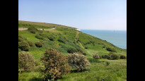
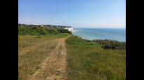
From Dover seafront, the route basically follows the England Coast Path and Saxon Shore Way all the way to Deal, and it is very well signed. From the end of Dover seafront the route goes along East Cliff and up the steep Dame Vera Lynn Way, which ends in a long flight of steps and another steep climb. Once at the top, it follows the main route through the National Trust's White Cliffs of Dover. There are several minor paths along the cliffs which could be followed, all with excellent views over Dover Eastern Docks and the busiest part of the English Channel. All the paths converge at Langdon Hole, where the National Trust has recently upgraded the main footpath all the way to the South Foreland Lighthouse just outside St Margaret's.
At St Margaret's Bay, the route diverges briefly from the England Coast Path/Saxon Shore Way (which go down to the beach - pub, cafe and toilets), and continues at the upper level towards the Dover Patrol Monument. From here the path swoops down and then back up to the golf course at Kingsdown Leas, with impressive views north along the coastline to Deal, Sandwich Bay, and Thanet beyond. There are some steep and irregular steps behind the clubhouse, which lead down the the beach road at Kingsdown. From here it is level all the way to Deal.
There are lots of places to rest along the way, with refreshments and public toilets at Dover, White Cliffs, South Foreland Lighthouse, St Margaret's Bay, Kingsdown, Walmer and Deal.
Mtormey
13 Nov 2022I walked this route from Dover to Deal. I found the gpx a bit imprecise for my liking, and the route made a few choices that I wouldn't have! If you walk this route, you shouldn't have any trouble, and it's a perfectly good route, but I've uploaded DovDea two that should be a bit more precise to follow.
-
Share your thoughts
RoamingAmy
24 Apr 2021Very easy and clear to follow, breath taking views all around, lots of variety along the path. Getting onto the walk is somewhat hard to find in Dover, and is best approached from the seafront and beach at Dover. There are several paths along the way that take you up or down the hill but still in the same direction. The only caution is the cliff edges, take care with children and do not walk too close to the edge. Public loos are available at the National trust visitors centre cafe, at saint margarets Bay beach and a few in Deal town centre. It can be windy so bring an extra layer and a hat as it is quite exposed.
-
Share your thoughts
Share your views about this route, give it a star rating, indicate whether it should be verified or not.
Include information that will be useful to others considering to walk or wheel it.
You can add up to 15 photos.
Other Routes for Dover—Deal See all Slow Ways
Review this better route and help establish a trusted network of walking routes.
Suggest a better route if it better meets our methodology.
Share your thoughts