Description
Route details include elevation
Route details include elevation
Status
This route has been reviewed by 3 people.
There are no issues flagged.
Photos for Dorrei two


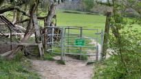

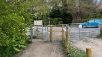
Photos of this route will appear when they are added to a review. You can review this route here.
Information
")
Route status - Live
Reviews - 3
Average rating -
Is this route good enough? - Yes (3)
There are currently no problems reported with this route.
Downloads - 9
Surveys
What is this route like?
Surveys are submitted by fellow users of this website and show what you might expect from this Slow Ways route. Scroll down the page to read more detailed surveys.
| Grade 3X based on 1 surveys | Sign up or log in to survey this route. | ||
|---|---|---|---|
| Description | Note | ||
| Grade 3: Route includes rough surfaces that may include small boulders, potholes, shallow ruts, loose gravel, short muddy sections. Access grade X: At least one stile, flight of steps or other obstacle that is highly likely to block access for wheelchair and scooter users. |
Grading is based on average scores by surveyors. This slow way has 1 surveys. | ||
| Full grading description | |||
Only people who have completed our training can become Slow Ways surveyors and submit a survey. We do not vet contributors, so we cannot guarantee the quality or completeness of the surveys they complete. If you are dependent on the information being correct we recommend reading and comparing surveys before setting off.
Survey Photos
Facilities
Facilities in the middle third of this route.
Challenges
Potential challenges reported on this route. Some challenges are seasonal.
Obstacles
Obstacles on this route.
Accessibility
Is this route step and stile free?
Measurements
Surveyors were asked to measure the narrowest and steepest parts of paths.
The narrowest part of the path is 50.0cm (1)
The steepest uphill gradient walking East 18.0% (1)
The steepest uphill gradient West: no data
The steepest camber gradient across the path 19.0% (1)
How clear is the waymarking on the route: Clear (1)
Successfully completed
We asked route surveyors "Have you successfully completed this route with any of the following? If so, would you recommend it to someone with the same requirements?". Here is how they replied.
Recommended by an expert
We asked route surveyors "Are you a trained access professional, officer or expert? If so, is this route suitable for someone travelling with any of the following?" Here is how they replied.
Terrain
We asked route surveyors to estimate how much of the route goes through different kinds of terrain.
10.0% of the route is on roads (1)
5.0% of the route is lit at night (1)
10.0% of the route is paved (1)
5.0% of the route is muddy (1)
5.0% of the route is over rough ground (1)
There is no data on long grass
Report a problem with this data
1 surveys
Information from verified surveys.
Geography information system (GIS) data
Total length
Maximum elevation
Minimum elevation
Start and end points
Dorking
Grid Ref
TQ1643549288
Lat / Lon
51.23091° / -0.33373°
Easting / Northing
516,435E / 149,288N
What3Words
tinsel.chimp.motion
Reigate
Grid Ref
TQ2534550257
Lat / Lon
51.23773° / -0.20584°
Easting / Northing
525,345E / 150,257N
What3Words
unwanted.clap.tunnel
| Dorking | |
|---|---|
| Grid Ref | TQ1643549288 |
| Lat / Lon | 51.23091° / -0.33373° |
| Easting / Northing | 516,435E / 149,288N |
| What3Words | tinsel.chimp.motion |
| Reigate | |
|---|---|
| Grid Ref | TQ2534550257 |
| Lat / Lon | 51.23773° / -0.20584° |
| Easting / Northing | 525,345E / 150,257N |
| What3Words | unwanted.clap.tunnel |
Sorry Land Cover data is not currently available for this route. Please check back later.
reviews
Derick Rethans
02 Apr 2023I walked this on a grey, but increasingly lighter Saturday afternoon, with lots of rain in the last few days, from Dorking to Reigate.
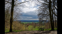
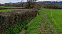
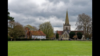
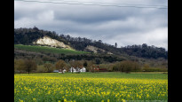
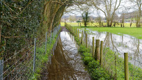
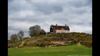
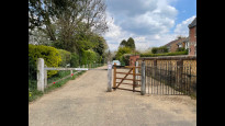
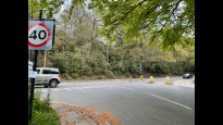
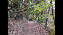
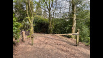
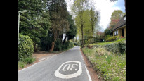
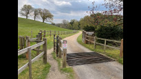
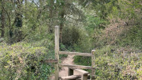
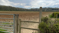
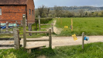
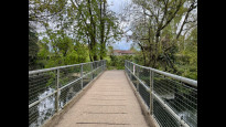
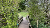
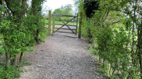
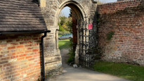
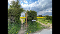
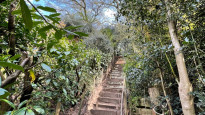
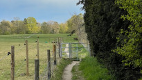
From the start there is an incline up towards Deepdene Avenue, which is a little hard to cross. The steep ascend to Deepdene Terrace (photo #1) is slightly further North along the road, and the path up to it is very steep. It has great views though (photo #2), and as this was my second walk of the day, I stopped here for packed lunch. From there on the route follows some roads (Deepdene Wood), and then along quiet lanes it goes through a public footpath towards Park Farm (photo #3). This is all quite lovely, with some stiles. After crossing under the railway, the route continued along a wet and muddy path over grass. This type of surface continued all the way around Pondtail Farm and along a stream (photo #4) to end up at Coach Road, which had a welcome and dry non-muddy surface. The route then continues towards Brockham (photo #5) where it crosses the River Mole on a bridle path. This was currently not possible as the river was too high. Instead, I had to detour along Brockham Lane and Kiln Lane before finding the footpath that was muddy and a steep incline to join at Mill Hill Lane again. In most cases, this wouldn't be necessary, so it doesn't warrant a new route. There are also pubs at Brockham Green too. The route then continues along lovely fields, with great views of the chalky North Downs (photo #6), although some sections were flooded (photo #7). After going through a churchyard, the route continues along a footpath a little higher up from a "Road liable to flooding" (photo #8) before turning North on the quiet Sandy Lane. After rounding the corner, there is a steep set of steps that leads you back up to farmland. A slightly detoured around a very muddy field before crossing some fields and stiles to end up at the Park Pit lake, where the route then continued through Dungates Lane where loads of Golden Retrievers where watching my progress. A path then gets you towards the Reigate Heath golf club with a windmill (photo #10), before dropping you at the Skimmington Castle pub along a narrow lane. From the Skimmington there is a muddy path (photo #11), first along Littleton Lane towards Reigate Park with its lake, before continuing towards Reigate along the busyish Park Lane.
It's again a great route, which I think I would have marked 5* if it wasn't this muddy.
Patbrown1886
06 May 2021Pleasant walk mainly along the Greensand Way. Pubs in Brockham, Betchworth and Skimmington make for useful refreshment stops. Hilly at the Dorking end but easy walking after this. Watch the navigation where Sandy Lane meets Old Road near Wonham - need to go onto Old Road briefly otherwise it's easy to turn right up a private road by mistake. Walked this from Dorking to Reigate and then quick half hourly train service back to Dorking.
-
Share your thoughts
Tractiveeffort
02 May 2021Overall, this route is a pleasant walk through Surrey countryside, with a challenging section at the Dorking end (west to east) up to Deepdene Terrace with the reward of a view over the Downs. The start and end points are easily reachable by public transport and are good town centres with plenty of facilities; there are also three intermediate points along the route where you can stop at a pub; there are also shops and public transport in Brockham and Betchworth. The route isn't accessible to wheels as it includes some steep woodland sections and many stiles.
-
Share your thoughts
Share your views about this route, give it a star rating, indicate whether it should be verified or not.
Include information that will be useful to others considering to walk or wheel it.
You can add up to 15 photos.
Other Routes for Dorking—Reigate See all Slow Ways
Review this better route and help establish a trusted network of walking routes.
Suggest a better route if it better meets our methodology.
Share your thoughts