West Chiltington Common — Storrington
Wessto one

Slow Way not verified yet. Verify Wessto here.
Slow Way not verified yet. Verify Wessto here.
By a Slow Ways Volunteer on 07 Apr 2021
Description
This is a Slow Ways route connecting West Chiltington Common and Storrington.
Know of a better route? Share it here.
This is a Slow Ways route connecting West Chiltington Common and Storrington.
Know of a better route? Share it here.
Status
This route has been reviewed by 3 people.
This route has been flagged (1 times) for reasons relating to safety.
Photos for Wessto one


Photos of this route will appear when they are added to a review. You can review this route here.
Information
Route status - Live
Reviews - 3
Average rating -
Is this route good enough? - Yes (2) Maybe (1)
Problems reported - Safety (1)
Downloads - 5
Surveys
What is this route like?
Surveys are submitted by fellow users of this website and show what you might expect from this Slow Ways route. Scroll down the page to read more detailed surveys.
| Grade 3X based on 1 surveys | Sign up or log in to survey this route. | ||
|---|---|---|---|
| Description | Note | ||
| Grade 3: Route includes rough surfaces that may include small boulders, potholes, shallow ruts, loose gravel, short muddy sections. Access grade X: At least one stile, flight of steps or other obstacle that is highly likely to block access for wheelchair and scooter users. |
Grading is based on average scores by surveyors. This slow way has 1 surveys. | ||
| Full grading description | |||
Only people who have completed our training can become Slow Ways surveyors and submit a survey. We do not vet contributors, so we cannot guarantee the quality or completeness of the surveys they complete. If you are dependent on the information being correct we recommend reading and comparing surveys before setting off.
Survey Photos
Facilities
Facilities in the middle third of this route.
Challenges
Potential challenges reported on this route. Some challenges are seasonal.
Obstacles
Obstacles on this route.
Accessibility
Is this route step and stile free?
Measurements
Surveyors were asked to measure the narrowest and steepest parts of paths.
Narrowest part of path: no data
The steepest uphill gradient East: no data
The steepest uphill gradient West: no data
The steepest camber: no data
How clear is the waymarking on the route: Unclear in places (1)
Successfully completed
We asked route surveyors "Have you successfully completed this route with any of the following? If so, would you recommend it to someone with the same requirements?". Here is how they replied.
Recommended by an expert
We asked route surveyors "Are you a trained access professional, officer or expert? If so, is this route suitable for someone travelling with any of the following?" Here is how they replied.
Terrain
We asked route surveyors to estimate how much of the route goes through different kinds of terrain.
25.0% of the route is on roads (1)
15.0% of the route is lit at night (1)
25.0% of the route is paved (1)
20.0% of the route is muddy (1)
20.0% of the route is over rough ground (1)
5.0% of the route is through long grass (1)
Report a problem with this data
1 surveys
Information from verified surveys.
Geography information system (GIS) data
Total length
Maximum elevation
Minimum elevation
Start and end points
West Chiltington Common
Grid Ref
TQ0841317420
Lat / Lon
50.94603° / -0.45813°
Easting / Northing
508,413E / 117,420N
What3Words
thankful.devoured.volunteered
Storrington
Grid Ref
TQ0872614284
Lat / Lon
50.91778° / -0.45461°
Easting / Northing
508,726E / 114,284N
What3Words
shortens.ombudsman.sampling
Wessto One's land is
| West Chiltington Common | |
|---|---|
| Grid Ref | TQ0841317420 |
| Lat / Lon | 50.94603° / -0.45813° |
| Easting / Northing | 508,413E / 117,420N |
| What3Words | thankful.devoured.volunteered |
| Storrington | |
|---|---|
| Grid Ref | TQ0872614284 |
| Lat / Lon | 50.91778° / -0.45461° |
| Easting / Northing | 508,726E / 114,284N |
| What3Words | shortens.ombudsman.sampling |
| Pasture | 29.8% |
| Urban | 70.2% |
Data: Corine Land Cover (CLC) 2018
reviews
Srsaunders
03 Mar 2024It's an ok short route but as others have commented the sections where you';re walking along verges to avoid being on the busy road aren't nice. WesSto 2 is nicer, recommend using that, but this is not actually dangerous provided you're not tempted to walk on the road.
Bostal Boy
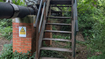
11 Sep 2021This is quite a short route which I walked from Storrington to WCC. The paths out of Storrington pass between and behind gardens and there were several obstacles. These included steps, cycle barriers and a high steel bridge over a small stream, with about 10 steps at either end. Once out of Storrington the route is pleasant, following field paths. There are several stiles and kissing gates, some of the paths were encroached by tall nettles, brambles and unruly hedges.
Once into WCC, the route becomes a quiet lane past nice 1920s/30s mock-rural thatched cottages. The final section was along Common Hill for about half a mile (a bus route). Provision for pedestrians along this road felt like a grudging afterthought, you have to walk along the verge in front people's houses for some of the way. Wide enough to pass though - not dangerous.
When I reached the destination, West Chiltington Common crossroads, I was left scratching my head as to why this has been chosen as a Slow Ways place. I found a garage that no longer sells petrol, a post office minimart and a hairdressers. Bemused, I walked off towards Pulborough (which should be a Slow Ways place) to catch a train home.
The route is well traced on the map. Some wobbly stiles and missing footpath signs on the ground.
-
Srsaunders
03 Mar 2024Fully agree that choosing West Chilt as a Place but not Pulborough is bizarre! West Chilt is so close to Storrington that it really doesn't seem necessary. Still, no harm done!
-
Share your thoughts
Sophie Reynolds
30 May 2021Lovely route out of Storrington but the way along the River Stor and around Fryern Park can be very muddy after wet weather.
The final section, along Common Hill can be busy with traffic and is a bus route.
-
Share your thoughts
Share your views about this route, give it a star rating, indicate whether it should be verified or not.
Include information that will be useful to others considering to walk or wheel it.
You can add up to 15 photos.
Other Routes for West Chiltington Common—Storrington See all Slow Ways
Review this better route and help establish a trusted network of walking routes.
Suggest a better route if it better meets our methodology.
Share your thoughts