Description
This is a Slow Ways route connecting Sutton and Wallington.
Know of a better route? Share it here.
This is a Slow Ways route connecting Sutton and Wallington.
Know of a better route? Share it here.
Status
This route has been reviewed by 3 people.
There are no issues flagged.
Photos for Sutwal one


Photos of this route will appear when they are added to a review. You can review this route here.
Information
")
Route status - Live
Reviews - 3
Average rating -
Is this route good enough? - Yes (3)
There are currently no problems reported with this route.
Downloads - 4
Surveys
We are working to build-up a picture of what routes look like. To do that we are asking volunteers to survey routes so that we can communicate features, obstacles and challenges that may make a route desirable or not.
Slow Ways surveyors are asked to complete some basic online training, but they are not vetted. If you are dependent on the survey information being correct in order to complete a route, we recommend that you think critically about the information provided. You may also wish to wait until more than one survey has been completed.
Help people know more about this route by volunteering to submit a survey.
- Complete the survey training.
- Submit a survey for this route.
Geography information system (GIS) data
Total length
Maximum elevation
Minimum elevation
Start and end points
Sutton
Grid Ref
TQ2603463832
Lat / Lon
51.35958° / -0.19119°
Easting / Northing
526,034E / 163,832N
What3Words
noise.acid.invest
Wallington
Grid Ref
TQ2885564000
Lat / Lon
51.36046° / -0.15063°
Easting / Northing
528,855E / 164,000N
What3Words
fake.bronze.races
Sutwal One's land is
| Sutton | |
|---|---|
| Grid Ref | TQ2603463832 |
| Lat / Lon | 51.35958° / -0.19119° |
| Easting / Northing | 526,034E / 163,832N |
| What3Words | noise.acid.invest |
| Wallington | |
|---|---|
| Grid Ref | TQ2885564000 |
| Lat / Lon | 51.36046° / -0.15063° |
| Easting / Northing | 528,855E / 164,000N |
| What3Words | fake.bronze.races |
| Urban | 100.0% |
Data: Corine Land Cover (CLC) 2018
reviews
Jane Taylor
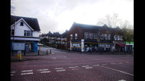
21 Mar 2024Walked Sutton to Wallington.
Good direct urban route through pleasant residential area of South London. Rolling hills, under the asphalt the North Downs are here.
Refreshments at Carshalton Beeches (half way).
No issues and does the job!.
Derick Rethans
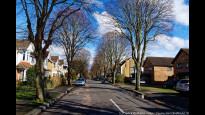
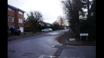
03 Mar 2024I walked this on a sunny, but slightly cloudy afternoon, from Sutton to Wallington. It had rained a lot in the morning.
A nearly fully urban route on pavements, but with plenty of greenery.
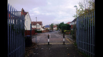
From Sutton's busy high street, you soon find yourself on a path next to a quiet road (photo #1), first up hill, then down hill (photo #2), and then up hill again (photo #3). Park Hill was a little busier, but not hard to cross. And there were shops too. Park Lane was a little busier, but there is a crossing point as well.
-
Share your thoughts
JohnMyerson
03 Dec 2022Straightforward walk on mainly quiet roads. A couple of busy roads to cross but not difficult. Shops at Carshalton Beeches (around halfway).
-
Share your thoughts
Share your views about this route, give it a star rating, indicate whether it should be verified or not.
Include information that will be useful to others considering to walk or wheel it.
You can add up to 15 photos.
Other Routes for Sutton—Wallington See all Slow Ways
Review this better route and help establish a trusted network of walking routes.
Suggest a better route if it better meets our methodology.
Share your thoughts