Stanwell Moor — Ashford (Spelthorne)
Staash two

Verified Slow Way
Verified by 100.00% of reviewers
Verified Slow Way
Verified by 100.00% of reviewers
By Jane Taylor on 14 Nov 2022
Description
Improved version of Staash One. At the Stanwell Moor end I've swopped out a big chunk of the Horton Road for a good quality footpath/cycle path; and at Stanwell I've taken out the inaccessible, blocked and unfriendly footpath around the back of the houses, and routed across the local recreation ground and around the residential street in front of the houses instead. I've kept the footpath between Park Road and the recreation ground, which is better used, I didn't find it so unwelcoming, and it does cut out a considerable chunk of road.
Elsewhere I've tightened up the route line and indicated crossing points
Status
This route has been reviewed by 3 people.
There are no issues flagged.
Photos for Staash two


Photos of this route will appear when they are added to a review. You can review this route here.
Information
Route status - Live
Reviews - 3
Average rating -
Is this route good enough? - Yes (3)
There are currently no problems reported with this route.
Downloads - 2
Surveys
What is this route like?
Surveys are submitted by fellow users of this website and show what you might expect from this Slow Ways route. Scroll down the page to read more detailed surveys.
| Grade 2X based on 1 surveys | Sign up or log in to survey this route. | ||
|---|---|---|---|
| Description | Note | ||
| Grade 2: Mostly smooth and compacted surfaces, but there may be some loose gravel, muddy patches or cobbles. Access grade X: At least one stile, flight of steps or other obstacle that is highly likely to block access for wheelchair and scooter users. |
Grading is based on average scores by surveyors. This slow way has 1 surveys. | ||
| Full grading description | |||
Only people who have completed our training can become Slow Ways surveyors and submit a survey. We do not vet contributors, so we cannot guarantee the quality or completeness of the surveys they complete. If you are dependent on the information being correct we recommend reading and comparing surveys before setting off.
Survey Photos
Facilities
Facilities in the middle third of this route.
Challenges
Potential challenges reported on this route. Some challenges are seasonal.
Obstacles
Obstacles on this route.
Accessibility
Is this route step and stile free?
Measurements
Surveyors were asked to measure the narrowest and steepest parts of paths.
The narrowest part of the path is 50.0cm (1)
The steepest uphill gradient walking East 4.0% (1)
The steepest uphill gradient walking West 6.0% (1)
The steepest camber gradient across the path 3.0% (1)
How clear is the waymarking on the route: Unsigned (1)
Successfully completed
We asked route surveyors "Have you successfully completed this route with any of the following? If so, would you recommend it to someone with the same requirements?". Here is how they replied.
Recommended by an expert
We asked route surveyors "Are you a trained access professional, officer or expert? If so, is this route suitable for someone travelling with any of the following?" Here is how they replied.
Terrain
We asked route surveyors to estimate how much of the route goes through different kinds of terrain.
60.0% of the route is on roads (1)
60.0% of the route is lit at night (1)
60.0% of the route is paved (1)
10.0% of the route is muddy (1)
2.0% of the route is over rough ground (1)
There is no data on long grass
Report a problem with this data
1 surveys
Information from verified surveys.
Geography information system (GIS) data
Total length
Maximum elevation
Minimum elevation
Start and end points
Stanwell Moor
Grid Ref
TQ0415174785
Lat / Lon
51.46247° / -0.50215°
Easting / Northing
504,151E / 174,785N
What3Words
scenes.topped.visits
Ashford (Spelthorne)
Grid Ref
TQ0658571930
Lat / Lon
51.43635° / -0.46798°
Easting / Northing
506,585E / 171,930N
What3Words
bend.images.stray
| Stanwell Moor | |
|---|---|
| Grid Ref | TQ0415174785 |
| Lat / Lon | 51.46247° / -0.50215° |
| Easting / Northing | 504,151E / 174,785N |
| What3Words | scenes.topped.visits |
| Ashford (Spelthorne) | |
|---|---|
| Grid Ref | TQ0658571930 |
| Lat / Lon | 51.43635° / -0.46798° |
| Easting / Northing | 506,585E / 171,930N |
| What3Words | bend.images.stray |
Sorry Land Cover data is not currently available for this route. Please check back later.
reviews
Aamwalk
10 Oct 2023I walked Ashford to Stanwell Moor as part of a loop made of three routes on a warn autumn afternoon.
From the Ashford rail station you climb a set stairs to get to church road bridge over the line. There is a longer route to the right if you are unable to do the stairs.
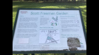
Otherwise, It is a straightforward route that is easy to follow and uses pavements and tarmacked paths. Mostly it is residencial streets. There is a small park (Scott Freeman Garden) and info board (see photo).
At Stanwell it goes through a housing estate and should then follow a path by the reservoir fence, but was partially overgrown, I could have pushed my way through, but decided to use the Town Road instead. It was visible clearer from the other end (see photos).
At the Stanwell Moor end I do love the river that runs along the residencial Hithermoor road (see photo under review of stahou).
Only three stars as though a straightforward route to follow less green spaces than other routes in the area.
Strider
06 May 2023I walked from Stanwell Moor to Ashford.
I gave 4* but 3½ really, quite road based and hemmed in footpaths. But, as off road and direct as possible with some very nice parts.
Starting in Stanwell Moor I ate lunch on a nice bench on a green 300m from the start. A cycle path takes you past the King George Reservoir then over the A3044 and along Park Road with a tricky crossing on a corner. Then around the Stains Reservoir along a narrow path beginning to get overgrown. It is a pity you cant see the reservoirs just high grassy banks. Roadside walking to Ashford station (roadworks at the station May 23). Lots of shops a bit past the station.
Stanwell Moor is very quiet, I'd walked from Iver to Ashford via Stanwell making this a lovely station to station walk.
No specific barriers to wheels but the path past Stains Reservoir is very narrow.
-
Share your thoughts
Jane Taylor
14 Nov 2022Walked Stanwell Moor to Ashford.
Reasonably direct route which makes the most of the available options.
Mostly firm pavement or asphalt path; one section of footpath at Stanwell (photo) is narrower and may be a bit muddy and rubbish strewn in places. However as there isn’t much ‘off road’ on this route it provides variety, and there are sheep on the other side of the fence (photo).
There are refreshments at the big A30 road junction.
Steps at Ashford station, these can be avoided by walking round on the road.
A big improvement on Staash One imo!.
-
Share your thoughts
Share your views about this route, give it a star rating, indicate whether it should be verified or not.
Include information that will be useful to others considering to walk or wheel it.
You can add up to 15 photos.
Other Routes for Stanwell Moor—Ashford (Spelthorne) See all Slow Ways
Review this better route and help establish a trusted network of walking routes.
Suggest a better route if it better meets our methodology.
Share your thoughts