Description
I created this alternative route, which uses a former railway line, slightly less exposed than the river, partly as an opportunity to find a step-free way of reaching the bridge over the River Dee from the Shotton meeting point.
Co-incidentally, Hiking Historian came up with exactly the same alternative, including both ends of the route, and even walked it on the same day, although our respective schedules didn’t allow us to walk together. Anyway, he deserves half the credit!!
Status
This route has been reviewed by 1 person.
There are no issues flagged.
Photos for Shoche two


Photos of this route will appear when they are added to a review. You can review this route here.
Information

Route status - Live
Reviews - 1
Average rating -
Is this route good enough? - Yes (1)
There are currently no problems reported with this route.
Downloads - 0
Surveys
What is this route like?
Surveys are submitted by fellow users of this website and show what you might expect from this Slow Ways route. Scroll down the page to read more detailed surveys.
| Grade 2X based on 1 surveys | Sign up or log in to survey this route. | ||
|---|---|---|---|
| Description | Note | ||
| Grade 2: Mostly smooth and compacted surfaces, but there may be some loose gravel, muddy patches or cobbles. Access grade X: At least one stile, flight of steps or other obstacle that is highly likely to block access for wheelchair and scooter users. |
Grading is based on average scores by surveyors. This slow way has 1 surveys. | ||
| Full grading description | |||
Only people who have completed our training can become Slow Ways surveyors and submit a survey. We do not vet contributors, so we cannot guarantee the quality or completeness of the surveys they complete. If you are dependent on the information being correct we recommend reading and comparing surveys before setting off.
Survey Photos
Facilities
Facilities in the middle third of this route.
Challenges
Potential challenges reported on this route. Some challenges are seasonal.
Obstacles
Obstacles on this route.
Accessibility
Is this route step and stile free?
Measurements
Surveyors were asked to measure the narrowest and steepest parts of paths.
The narrowest part of the path is 40.0cm (1)
The steepest uphill gradient walking East 16.0% (1)
The steepest uphill gradient walking West 21.0% (1)
The steepest camber: no data
How clear is the waymarking on the route: Very clear (1)
Successfully completed
We asked route surveyors "Have you successfully completed this route with any of the following? If so, would you recommend it to someone with the same requirements?". Here is how they replied.
Recommended by an expert
We asked route surveyors "Are you a trained access professional, officer or expert? If so, is this route suitable for someone travelling with any of the following?" Here is how they replied.
Terrain
We asked route surveyors to estimate how much of the route goes through different kinds of terrain.
There is no data on how much of this route is on roads
There is no data on how much of this route is lit at night
Thereis no data on amount of route paved
There is no data on muddiness
There is no data on rough ground
There is no data on long grass
Report a problem with this data
1 surveys
Information from verified surveys.
Geography information system (GIS) data
Total length
Maximum elevation
Minimum elevation
Start and end points
Shotton
Grid Ref
SJ3069368861
Lat / Lon
53.21229° / -3.03927°
Easting / Northing
330,693E / 368,861N
What3Words
ambient.happier.inspects
Chester
Grid Ref
SJ4052966286
Lat / Lon
53.19034° / -2.89153°
Easting / Northing
340,529E / 366,286N
What3Words
bridge.assist.chair
| Shotton | |
|---|---|
| Grid Ref | SJ3069368861 |
| Lat / Lon | 53.21229° / -3.03927° |
| Easting / Northing | 330,693E / 368,861N |
| What3Words | ambient.happier.inspects |
| Chester | |
|---|---|
| Grid Ref | SJ4052966286 |
| Lat / Lon | 53.19034° / -2.89153° |
| Easting / Northing | 340,529E / 366,286N |
| What3Words | bridge.assist.chair |
Sorry Land Cover data is not currently available for this route. Please check back later.
review
Mary Oz
17 Mar 2024From Shotton the route follows a quiet road with speed humps for step free access to Hawarden Bridge. From here the route is nearly all shared use cycle track, although it does include several cycle barriers which slope in to a gap of 40cm at the top at a height of about 1.5 metres. Crossing the bridge over the River Dee, alongside (but safely away from) the railway is great fun, with excellent view towards Chester.
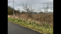
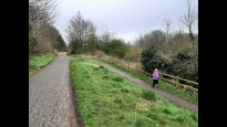
The track continues straight on past Hawarden Bridge Station and is incredibly easy to follow. After a long gentle curve, the route is dead straight for four and a half miles. There is a bit of industry and house-building along the route to start with, but it is not close by.
I walked this on a Saturday afternoon and there were quite a lot of cyclists and loose dog walkers, but generally it all felt very safe and pleasant. I saw or heard cormorant, woodpecker, skylark and rabbit.
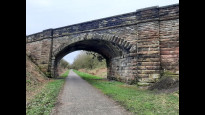
From the bridge over the busy A494 I got a good view of the Clwyd hills including Moel Famau. I also got a view of the former Sealand Army camp, which I think is still in use by the MoD. (I’m not very knowledgeable about this but Hiking Historian may know.)
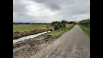
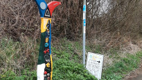
From here until Blacon was much more rural, and not busy, although I could still hear some traffic noise, and also the nearby shooting school. It felt as if this long straight stretch would go on forever, but it was broken up by occasional bridges and stone benches, and then by the sign marking the Wales/England border.
The path and verges were all well maintained. St Bartholomews Church in Sealand has a café that’s open 10am-2pm Monday to Wednesday, near the middle of the route, and there’s a pub, shop and buses in Saughall.
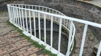
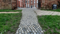
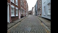
Not long after passing Blacon, I reached the slope down to the canal towpath. The route into Chester was very interesting, using a footbridge with a curved ramp, passing a dry dock, and the remarkable Northgate Staircase locks, and then going up a cobbled slope and under Chester Walls. Along a cobbled street, and I was soon into the lovely city centre.
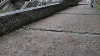
The route is entirely step-free, nearly all tarmac, and the only potential restrictions for wheel users are described above.
Share your views about this route, give it a star rating, indicate whether it should be verified or not.
Include information that will be useful to others considering to walk or wheel it.
You can add up to 15 photos.
Other Routes for Shotton—Chester See all Slow Ways
Review this better route and help establish a trusted network of walking routes.
Suggest a better route if it better meets our methodology.
Share your thoughts