Description
This route is based on Rengla One, improved by replacing most of the dull busy main road walking with a stretch of interesting local shops and eateries through Partick. Much better in my opinion!
Route uses Renfrew ferry to cross the Clyde, which operates an 'on demand' service. It's pretty reliable during daytime hours, but worth checking it is running before you go.
Once on the north side of the Clyde the route follows an excellent cycle/pedestrian off road path most of the way to Partick. A feature of this part of the route are the pigeon lofts (the local term is 'dookits') which belong to local pigeon fanciers.
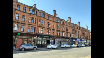
There is a short walk along a main road (with a view of a shipyard) before turning away from the river to Partick. There are a lot of places to eat and drink in this section, and a nice picnic spot at Mansfield Park.
The route takes a tiny detour to cross the river Kelvin by the pedestrian bridge, and then goes directly outside Kelvingrove Art Gallery and Museum, free entry and a good cafe.
After this it's a straight line through Finnieston all the way to the M8 crossing at Anderston bridge, and from there to the end point in central Glasgow
This route is based on Rengla One, improved by replacing most of the dull busy main road walking with a stretch of interesting local shops and eateries through Partick. Much better in my opinion!
Route uses Renfrew ferry to cross the Clyde, which operates an 'on demand' service. It's pretty reliable during daytime hours, but worth checking it is running before you go.
Once on the north side of the Clyde the route follows an excellent cycle/pedestrian off road path most of the way to Partick. A feature of this part of the route are the pigeon lofts (the local term is 'dookits') which belong to local pigeon fanciers.
There is a short walk along a main road (with a view of a shipyard) before turning away from the river to Partick. There are a lot of places to eat and drink in this section, and a nice picnic spot at Mansfield Park.
The route takes a tiny detour to cross the river Kelvin by the pedestrian bridge, and then goes directly outside Kelvingrove Art Gallery and Museum, free entry and a good cafe.
After this it's a straight line through Finnieston all the way to the M8 crossing at Anderston bridge, and from there to the end point in central Glasgow
Status
This route has been reviewed by 4 people.
There are no issues flagged.
Photos for Rengla two


Photos of this route will appear when they are added to a review. You can review this route here.
Information
")
Route status - Live
Reviews - 4
Average rating -
Is this route good enough? - Yes (4)
There are currently no problems reported with this route.
Downloads - 4
Surveys
We are working to build-up a picture of what routes look like. To do that we are asking volunteers to survey routes so that we can communicate features, obstacles and challenges that may make a route desirable or not.
Slow Ways surveyors are asked to complete some basic online training, but they are not vetted. If you are dependent on the survey information being correct in order to complete a route, we recommend that you think critically about the information provided. You may also wish to wait until more than one survey has been completed.
Help people know more about this route by volunteering to submit a survey.
- Complete the survey training.
- Submit a survey for this route.
Geography information system (GIS) data
Total length
Maximum elevation
Minimum elevation
Start and end points
Renfrew
Grid Ref
NS5078867652
Lat / Lon
55.87884° / -4.38674°
Easting / Northing
250,788E / 667,652N
What3Words
asking.blocks.offer
Glasgow
Grid Ref
NS5873965347
Lat / Lon
55.86055° / -4.25855°
Easting / Northing
258,739E / 665,348N
What3Words
this.chop.tasty
| Renfrew | |
|---|---|
| Grid Ref | NS5078867652 |
| Lat / Lon | 55.87884° / -4.38674° |
| Easting / Northing | 250,788E / 667,652N |
| What3Words | asking.blocks.offer |
| Glasgow | |
|---|---|
| Grid Ref | NS5873965347 |
| Lat / Lon | 55.86055° / -4.25855° |
| Easting / Northing | 258,739E / 665,348N |
| What3Words | this.chop.tasty |
Sorry Land Cover data is not currently available for this route. Please check back later.
Other Routes for Renfrew—Glasgow See all Slow Ways
Review this better route and help establish a trusted network of walking routes.
Suggest a better route if it better meets our methodology.