Description
This is a Slow Ways route connecting Melksham and Devizes.
Know of a better route? Share it here.
This is a Slow Ways route connecting Melksham and Devizes.
Know of a better route? Share it here.
Status
This route has been reviewed by 3 people.
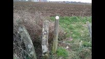
This route has been flagged (3 times) for reasons relating to access.
Photos for Meldev one


Photos of this route will appear when they are added to a review. You can review this route here.
Information

Route status - Live
Reviews - 3
Average rating -
Is this route good enough? - No (2) Maybe (1)
Problems reported - Access (3)
Downloads - 13
Surveys
What is this route like?
Surveys are submitted by fellow users of this website and show what you might expect from this Slow Ways route. Scroll down the page to read more detailed surveys.
| Grade 3X based on 1 surveys | Sign up or log in to survey this route. | ||
|---|---|---|---|
| Description | Note | ||
| Grade 3: Route includes rough surfaces that may include small boulders, potholes, shallow ruts, loose gravel, short muddy sections. Access grade X: At least one stile, flight of steps or other obstacle that is highly likely to block access for wheelchair and scooter users. |
Grading is based on average scores by surveyors. This slow way has 1 surveys. | ||
| Full grading description | |||
Only people who have completed our training can become Slow Ways surveyors and submit a survey. We do not vet contributors, so we cannot guarantee the quality or completeness of the surveys they complete. If you are dependent on the information being correct we recommend reading and comparing surveys before setting off.
Survey Photos

Facilities
Facilities in the middle third of this route.
Challenges
Potential challenges reported on this route. Some challenges are seasonal.
Obstacles
Obstacles on this route.
Accessibility
Is this route step and stile free?
Measurements
Surveyors were asked to measure the narrowest and steepest parts of paths.
The narrowest part of the path is 60.0cm (1)
The steepest uphill gradient walking East 20.0% (1)
The steepest uphill gradient walking West 10.0% (1)
The steepest camber gradient across the path 5.0% (1)
How clear is the waymarking on the route: Unclear in places (1)
Successfully completed
We asked route surveyors "Have you successfully completed this route with any of the following? If so, would you recommend it to someone with the same requirements?". Here is how they replied.
Recommended by an expert
We asked route surveyors "Are you a trained access professional, officer or expert? If so, is this route suitable for someone travelling with any of the following?" Here is how they replied.
Terrain
We asked route surveyors to estimate how much of the route goes through different kinds of terrain.
3.0% of the route is on roads (1)
17.0% of the route is lit at night (1)
62.0% of the route is paved (1)
5.0% of the route is muddy (1)
5.0% of the route is over rough ground (1)
1.0% of the route is through long grass (1)
Report a problem with this data
1 surveys
Information from verified surveys.
Geography information system (GIS) data
Total length
Maximum elevation
Minimum elevation
Start and end points
Melksham
Grid Ref
ST9045663638
Lat / Lon
51.37172° / -2.13849°
Easting / Northing
390,456E / 163,638N
What3Words
amplified.diverged.digestion
Devizes
Grid Ref
SU0040261483
Lat / Lon
51.35242° / -1.99561°
Easting / Northing
400,402E / 161,483N
What3Words
barbarian.stop.likely
Meldev One's land is
| Melksham | |
|---|---|
| Grid Ref | ST9045663638 |
| Lat / Lon | 51.37172° / -2.13849° |
| Easting / Northing | 390,456E / 163,638N |
| What3Words | amplified.diverged.digestion |
| Devizes | |
|---|---|
| Grid Ref | SU0040261483 |
| Lat / Lon | 51.35242° / -1.99561° |
| Easting / Northing | 400,402E / 161,483N |
| What3Words | barbarian.stop.likely |
| Arable | 13.4% |
| Pasture | 54.7% |
| Urban | 31.9% |
Data: Corine Land Cover (CLC) 2018
reviews
Brian
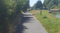
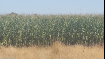
11 Aug 2022Being a resident of Melksham I am fully aware of the state of the footpaths in the Melksham and surrounding areas, Wiltshire Council will NOT condemn landowners who annually flagrantly break the law by planting maize which complete blocks the network of paths. From June to October this is a no go area. Like Peter I undertook this walk yesterday from Devizes to Melksham, and the sections from Devizes, along the canal, across fields to Redstocks is fine. From Redstocks on, there was
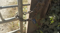
a) a locked field gate, which I have reported on a number of occasions to Wilts Council....to no avail
b)Maize in the final two field approaching Melksham, which is IMPASSABLE.
Out side these times the landowner ploughs the fields...see Peters photos
Meldev one is the worst of the four routes
If you wish to undertake, I suggest that when you reach the kissing gate at Oakfields Football / Rugby ground, that you skirt the perimeter, with the long grass on your right, all the way round to the tarmac parking, follow this out to the by pass then continue the route from there.
Peter Cooke
10 Feb 2022I tried walking this route from Devizes to Melksham, The canal sections were fine - but the farmland sections became very problematic where some footpaths across fields were impassable due to deep ploughing across the entire field and other areas were very muddy/flooded. I needed to rely on my OS maps + GPS to pick through some fields. Having looked at the other variations for Melksham-Devizes I think that MelDev04 is the optimum one for the network as it looks like a more reliable, more accessible route.
-
Share your thoughts
Brian
06 May 2021 (edited 27 Jun 2023)I agree with all the comments made to amend the route on Meldev two
I have slightly amended the Meldev two route to take out footpaths with stiles, and replaced with additional canal towpath.
-
Share your thoughts
Share your views about this route, give it a star rating, indicate whether it should be verified or not.
Include information that will be useful to others considering to walk or wheel it.
You can add up to 15 photos.
Other Routes for Melksham—Devizes See all Slow Ways
Review this better route and help establish a trusted network of walking routes.
Suggest a better route if it better meets our methodology.
Share your thoughts