Description
This is a Slow Ways route connecting Liverpool and Belle Vale.
Know of a better route? Share it here.
This is a Slow Ways route connecting Liverpool and Belle Vale.
Know of a better route? Share it here.
Status
This route has been reviewed by 3 people.
There are no issues flagged.
Photos for Livbel one

Photos of this route will appear when they are added to a review. You can review this route here.
Information
")
Route status - Live
Reviews - 3
Average rating -
Is this route good enough? - Yes (3)
There are currently no problems reported with this route.
Downloads - 4
Surveys
We are working to build-up a picture of what routes look like. To do that we are asking volunteers to survey routes so that we can communicate features, obstacles and challenges that may make a route desirable or not.
Slow Ways surveyors are asked to complete some basic online training, but they are not vetted. If you are dependent on the survey information being correct in order to complete a route, we recommend that you think critically about the information provided. You may also wish to wait until more than one survey has been completed.
Help people know more about this route by volunteering to submit a survey.
- Complete the survey training.
- Submit a survey for this route.
Geography information system (GIS) data
Total length
Maximum elevation
Minimum elevation
Start and end points
Liverpool
Grid Ref
SJ3502190540
Lat / Lon
53.40767° / -2.97892°
Easting / Northing
335,021E / 390,540N
What3Words
twice.email.bleak
Belle Vale
Grid Ref
SJ4320388575
Lat / Lon
53.39096° / -2.85550°
Easting / Northing
343,203E / 388,575N
What3Words
riders.pads.smoke
Livbel One's land is
| Liverpool | |
|---|---|
| Grid Ref | SJ3502190540 |
| Lat / Lon | 53.40767° / -2.97892° |
| Easting / Northing | 335,021E / 390,540N |
| What3Words | twice.email.bleak |
| Belle Vale | |
|---|---|
| Grid Ref | SJ4320388575 |
| Lat / Lon | 53.39096° / -2.85550° |
| Easting / Northing | 343,203E / 388,575N |
| What3Words | riders.pads.smoke |
| Green urban | 24.3% |
| Urban | 75.7% |
Data: Corine Land Cover (CLC) 2018
reviews
Hiking Historian
20 Jun 2022A fantastic route, going through some of Liverpool's parks.
It's accessible for all for most of the way, being along pavements in urban areas, and, and through Princes, Sefton and Calderstones parks, tarmacced footpaths.
The footpaths through Black Wood and Childwall Woods, however, are earthern; fine in hot weather, but may be muddy in wetter periods.
The route through the last two woods is sketchy and, at best, vague, showing paths and exits that don't exist; previous reviewers have failed to make note of this, especially that the exit from Childwall Woods to the road is via a few steps, and not where they are on the map.
I've verified this route, but only with the caveat that the route I have submitted as LIVBEL Two is to be followed, as it gives a more accurate representation of the route of the ground.
Team Tato
13 Apr 2022A very enjoyable route that takes in many great sights and beautiful green spaces in South Liverpool with some excellent pubs and coffee places along the way in case a stop is required. As an added bonus: most of these places actively welcome dogs. The route is mostly accessible, although it suffers somewhat in that department from a lack of dropped kerbs.
On a separate note, I would probably reroute the walk slightly to follow along Princes Road/Avenue as the newly refurbished middle section now allows for entirely off-road walking/cycling and follows a visually prettier area with lots of trees and greenery. As an added benefit, it shortens the route every so slightly too.
-
Share your thoughts
Jo G
29 May 2021This nine-mile route is easy walking and takes you through some of the most historic areas of Liverpool, three of its finest parks and past two cathedrals.
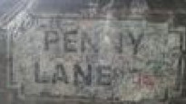
I ran/walked the route in two sessions, as it passes quite close to my house part way along. Starting out from Lime Street Station you head uphill towards the University of Liverpool precinct, passing the famous Victoria Building which was the source of the term 'redbrick' to denote the great civic universities of the late 19th Century. You then walk around the first cathedral -the Metropolitan which is affectionately known as 'Paddy's wigwam'. At the other end of Hope Street you find your second cathedral, the Anglican one. You can then walk easily along Windsor Street to reach your first park - Princes Park, which was Liverpool's first public park. It abuts onto its larger sister, Sefton Park - the largest park in Liverpool. Your route takes you past the Aviary Cafe and the adjacent fountain with a statue of Eros. Exit onto Greenbank Lane (not the adjacent Greenbank Drive) and you will also pass the entrance to another park - Greenbank Park which is smaller but very pretty. You then walk along Penny Lane, of Beatles fame, before meandering along quiet pleasant side streets to reach a large junction where there is a big Tesco's supermarket. Continuing along the quieter part of Allerton Road you will eventually reach the entrance to Calderstones Park, and a straightforward path takes you straight across, passing the Mansion House. A climb up Druid's Cross Road leads to the entrance to Black Wood - a simply lovely wood of mainly beech trees with a good path around it. On exiting you simply cross the road to join Childwall (pronounced Chilled-wall) Woods, which are also very pleasant. You pass Lime Pictures TV studios which is where Hollyoaks is filmed, to reach the Childwall Abbey pub and adjacent church. A route down Well Lane then leads to the old railway line - though I ended up meandering through side streets as I missed the turning. The route brings you out to finish by Belle Vale shopping centre where there is a Morrison's supermarket if you need provisions.
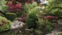
This route could of course be easily walked in 3 hours or so, but there is a lot of interest along the way so it's worth allowing longer if you can. As well as visiting one or both cathedrals (perhaps even ascending the tower of Liverpool Cathedral for a spectacular view of the city!), the Victoria Building has a small but interesting museum and gallery. Princes Park has a Wood Henge and there will soon be a memorial garden to Nelson Mandela too. Sefton Park's Palm House is just off the route but well worth visiting. Greenbank Park is also just off the route and houses a lovely walled garden with a memorial to Eleanor Rathbone, the feminist and social reformer, who lived in Greenbank House nearby. Calderstones Park is named after the Neolithic Calder Stones, which can be viewed at the rear of the Mansion House; it also has a 1000 year-old oak tree (just off the route) and you pass the entrance for the gorgeous walled garden, incorporating an Old English Garden and a Japanese garden.
There is no shortage of places to eat or buy provisions en route - Sefton, Greenbank and Calderstones Park all have cafes and there are also many places to eat on the busier part of Allerton Road. On Windsor Street there is a great place called Squash - opening times are limited but they serve lovely vegetarian/vegan food and do much more besides. My favourite cafe is probably the Watering Can in Greenbank Park.
There are also several alternative routes you can take:
Instead of passing along Hope Street past the Anglican Cathedral, detour to walk through St James' Gardens below it - a very peaceful old cemetery which houses an old chapel and a freshwater spring.
Instead of Windsor Street, you can reach Princes Park by turning left up Parliament Street to walk along Princes Avenue. Although this is a main road and dual carriageway, it has recently had the wide central boulevard turned into a safe, tree lined, pleasant route for bikes and walkers, together with installations at intervals telling the history of the Toxteth district and the multi-ethnic communities that created it. It leads to a different entrance to the park, which has beautiful gates with a gilded sunburst design.
Beatles fans might want to detour to inspect any or all of the following which are all within one or two kilometres from the route: the childhood homes of Ringo Starr (Madryn Street), John Lennon (Menlove Avenue) and Paul McCartney (Forthlin Road); Strawberry Field (Beaconsfield Road), and the grave of Eleanor Rigby and the church hall where John and Paul first met at a fete in 1957 (St Peter's Church Woolton).
-
Share your thoughts
Share your views about this route, give it a star rating, indicate whether it should be verified or not.
Include information that will be useful to others considering to walk or wheel it.
You can add up to 15 photos.
Other Routes for Liverpool—Belle Vale See all Slow Ways
Review this better route and help establish a trusted network of walking routes.
Suggest a better route if it better meets our methodology.
Share your thoughts