Description
This route largely avoids the main A6 by using green spaces and side streets
This route largely avoids the main A6 by using green spaces and side streets
Status
This route has been reviewed by 3 people.
There are no issues flagged.
Photos for Levsto two


Photos of this route will appear when they are added to a review. You can review this route here.
Information
")
Route status - Live
Reviews - 3
Average rating -
Is this route good enough? - Yes (3)
There are currently no problems reported with this route.
Downloads - 7
Surveys
What is this route like?
Surveys are submitted by fellow users of this website and show what you might expect from this Slow Ways route. Scroll down the page to read more detailed surveys.
| Grade 2X based on 1 surveys | Sign up or log in to survey this route. | ||
|---|---|---|---|
| Description | Note | ||
| Grade 2: Mostly smooth and compacted surfaces, but there may be some loose gravel, muddy patches or cobbles. Access grade X: At least one stile, flight of steps or other obstacle that is highly likely to block access for wheelchair and scooter users. |
Grading is based on average scores by surveyors. This slow way has 1 surveys. | ||
| Full grading description | |||
Only people who have completed our training can become Slow Ways surveyors and submit a survey. We do not vet contributors, so we cannot guarantee the quality or completeness of the surveys they complete. If you are dependent on the information being correct we recommend reading and comparing surveys before setting off.
Survey Photos
Facilities
Facilities in the middle third of this route.
Challenges
Potential challenges reported on this route. Some challenges are seasonal.
Obstacles
Obstacles on this route.
Accessibility
Is this route step and stile free?
Measurements
Surveyors were asked to measure the narrowest and steepest parts of paths.
Narrowest part of path: no data
The steepest uphill gradient East: no data
The steepest uphill gradient West: no data
The steepest camber: no data
How clear is the waymarking on the route: Unsigned (1)
Successfully completed
We asked route surveyors "Have you successfully completed this route with any of the following? If so, would you recommend it to someone with the same requirements?". Here is how they replied.
Recommended by an expert
We asked route surveyors "Are you a trained access professional, officer or expert? If so, is this route suitable for someone travelling with any of the following?" Here is how they replied.
Terrain
We asked route surveyors to estimate how much of the route goes through different kinds of terrain.
There is no data on how much of this route is on roads
There is no data on how much of this route is lit at night
Thereis no data on amount of route paved
There is no data on muddiness
There is no data on rough ground
There is no data on long grass
Report a problem with this data
1 surveys
Information from verified surveys.
Geography information system (GIS) data
Total length
Maximum elevation
Minimum elevation
Start and end points
Levenshulme
Grid Ref
SJ8728094176
Lat / Lon
53.44421° / -2.19297°
Easting / Northing
387,280E / 394,176N
What3Words
fees.sugar.urban
Stockport
Grid Ref
SJ8930189895
Lat / Lon
53.40578° / -2.16240°
Easting / Northing
389,301E / 389,895N
What3Words
cake.sushi.groom
| Levenshulme | |
|---|---|
| Grid Ref | SJ8728094176 |
| Lat / Lon | 53.44421° / -2.19297° |
| Easting / Northing | 387,280E / 394,176N |
| What3Words | fees.sugar.urban |
| Stockport | |
|---|---|
| Grid Ref | SJ8930189895 |
| Lat / Lon | 53.40578° / -2.16240° |
| Easting / Northing | 389,301E / 389,895N |
| What3Words | cake.sushi.groom |
Sorry Land Cover data is not currently available for this route. Please check back later.
reviews
Ken
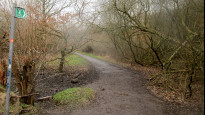
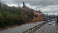
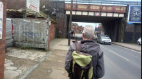
20 Feb 2023We walked from Stockport to Levenshulme the route out of Stockport station is currently impassable due to building work, so see LEVSTO 3 for an alternative start. The route as a whole is neither one thing nor the other. Here in a very urban setting I'm not sure this route works but wouldn't fail it, there are some good interesting and enjoyable parts but they are so different. I suspect it's not suitable for wheels with some steep or muddy paths. I did like the roadside walk beside the railway very different from a path alongside a road with just the occasional noise from a passing train. The buffer of trees and bushes offers a perch for songbirds. The green section approaching Levenshulme felt rural with mud, enjoyable but it felt like a tour especially leaving the A6 in sight of the biscuit factory which I thought marked the final leg of the walk.
Hugh Hudson
18 Feb 2023 (edited 19 Feb 2023)Walked from Stockport to Levenshulme. Most of this route is good and surprisingly pleasant, but the route north of Stockport station is currently impassable due to building work, so I have submitted LEVSTO 3, an alternative with a more direct route down to the shopping centre. I have not yet decided whether the blockages merit a flag.
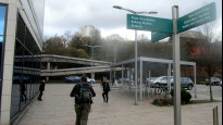
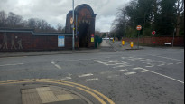
Leaving the meeting point outside Stockport station, we go north onto Station Road and almost immediately hit the first problem - the path across the corner is fenced off for building work, so we were forced to follow the road out to Wellington Road South, then go left down Exchange Road to rejoin the route. We then found that Swaine Street is also closed due to building work, so we diverted left across the railway and down Viaduct Street to reach the Mersey bridge and the right turn along Heaton Lane.
We cross Wellington Road and go straight on into the shopping centre, then left and right, past the Red Rock building and left again. There is a pelican crossing on Great Egerton Street leading to the M60 footbridge, which is accessed either using steps or a longer ramp. Beyond the bridge a cobbled street (Church Street) leads us up into parkland. We follow the TransPennine Trail signs right up Parsonage Street then left along an alleyway that leads back to Wellington Road North, where we turn right and follow the main road for some distance. There are several pelican crossings available to help cross it, the last of them at the junction with Warwick Road where we turn left.
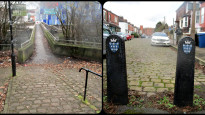
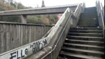
Just before the railway we take the path right that leads to Egerton Road South, which we follow up to Heaton Chapel station (which is accessed down a rather impressive bricked staircase). We go straight on up Egerton Road North and Chandos Road, then right on Alford Road. A pelican crossing helps us across Wellington Road North, and we go a short distance left before turning right onto Milwain Drive.
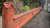
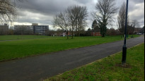
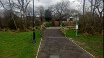
We turn right again down Meadows Road then straight on into the park, where we take the surfaced track left, then go left again after crossing the bridge over Black Brook. The path continues between the houses to another T junction where we go right, then almost immediately left on a good track that leads into the Highfield country park.
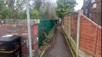
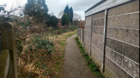
After a while we fork left onto an unsurfaced but good path that leads us to the bridge over an old railway cutting (Fallowfield Loop). Beyond the cutting the path goes left to reach Broom Lane, which we cross and go right then left along Chapel Street to reach Stockport Road, where we go left, cross and turn right down Albert Street to reach the meeting point outside Levenshulme station.
-
Share your thoughts
Ian V
02 May 2021This route mostly avoids the main road, using side streets and green spaces that regular travellers from Stockport to Manchester may have never seen.
-
Share your thoughts
Share your views about this route, give it a star rating, indicate whether it should be verified or not.
Include information that will be useful to others considering to walk or wheel it.
You can add up to 15 photos.
Other Routes for Levenshulme—Stockport See all Slow Ways
Review this better route and help establish a trusted network of walking routes.
Suggest a better route if it better meets our methodology.
Share your thoughts