Description
Iver to Stanwell Moor via the Colne Valley.
This is a great linking route for anyone who wants a green North/South route that bypasses the urbanised areas close to London.
It crosses the M25, M4, A4, the railway mainline from London to the West Country, and Heathrow airport; also various other bypasses and spurs in the Heathrow area - and manages to be mostly off road, with only short stretches of traffic (pavements throughout).
After a short walk south along Thorney Lane at Iver, join the canal and follow the towpath east, until you get to the start of a string of paths heading south which connect various green spaces along the Colne Valley.
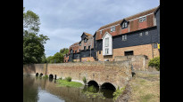
There's one more short road section along Thorney Mill Road (with a wonderful mill house straddling the river Colne), then pretty much you are off road the whole way to Stanwell Moor.
Harmondsworth Moor is a highlight, and I've routed along a ridge which gives outstanding 360º panoramic views: Windsor Castle, Heathrow T5 not so far, the Surrey Downs to the South.
Things to note:
The route passes the ends of Heathrow's two runways and it may be noisy.
The final underpass between the Colne Valley biodiversity site and Stanwell Moor has narrow access (I think to deter off road vehicles), and can seem a bit intimidating, but I made it through fine!!
There isn't really much by way of refreshments directly on route, so take a picnic. A shortish detour to Harmondsworth brings you to a decent pub in a lovely village setting, but will add a couple of km to the journey
Iver to Stanwell Moor via the Colne Valley.
This is a great linking route for anyone who wants a green North/South route that bypasses the urbanised areas close to London.
It crosses the M25, M4, A4, the railway mainline from London to the West Country, and Heathrow airport; also various other bypasses and spurs in the Heathrow area - and manages to be mostly off road, with only short stretches of traffic (pavements throughout).
After a short walk south along Thorney Lane at Iver, join the canal and follow the towpath east, until you get to the start of a string of paths heading south which connect various green spaces along the Colne Valley.
There's one more short road section along Thorney Mill Road (with a wonderful mill house straddling the river Colne), then pretty much you are off road the whole way to Stanwell Moor.
Harmondsworth Moor is a highlight, and I've routed along a ridge which gives outstanding 360º panoramic views: Windsor Castle, Heathrow T5 not so far, the Surrey Downs to the South.
Things to note:
The route passes the ends of Heathrow's two runways and it may be noisy.
The final underpass between the Colne Valley biodiversity site and Stanwell Moor has narrow access (I think to deter off road vehicles), and can seem a bit intimidating, but I made it through fine!!
There isn't really much by way of refreshments directly on route, so take a picnic. A shortish detour to Harmondsworth brings you to a decent pub in a lovely village setting, but will add a couple of km to the journey
Status
This route has been reviewed by 3 people.
There are no issues flagged.
Photos for Iversta three


Photos of this route will appear when they are added to a review. You can review this route here.
Information
")
Route status - Live
Reviews - 3
Average rating -
Is this route good enough? - Yes (3)
There are currently no problems reported with this route.
Downloads - 5
Surveys
What is this route like?
Surveys are submitted by fellow users of this website and show what you might expect from this Slow Ways route. Scroll down the page to read more detailed surveys.
| Grade 3X based on 1 surveys | Sign up or log in to survey this route. | ||
|---|---|---|---|
| Description | Note | ||
| Grade 3: Route includes rough surfaces that may include small boulders, potholes, shallow ruts, loose gravel, short muddy sections. Access grade X: At least one stile, flight of steps or other obstacle that is highly likely to block access for wheelchair and scooter users. |
Grading is based on average scores by surveyors. This slow way has 1 surveys. | ||
| Full grading description | |||
Only people who have completed our training can become Slow Ways surveyors and submit a survey. We do not vet contributors, so we cannot guarantee the quality or completeness of the surveys they complete. If you are dependent on the information being correct we recommend reading and comparing surveys before setting off.
Survey Photos
Facilities
Facilities in the middle third of this route.
Challenges
Potential challenges reported on this route. Some challenges are seasonal.
Obstacles
Obstacles on this route.
Accessibility
Is this route step and stile free?
Measurements
Surveyors were asked to measure the narrowest and steepest parts of paths.
The narrowest part of the path is 35.0cm (1)
The steepest uphill gradient walking East 14.0% (1)
The steepest uphill gradient walking West 14.0% (1)
The steepest camber gradient across the path 14.0% (1)
How clear is the waymarking on the route: Unclear in places (1)
Successfully completed
We asked route surveyors "Have you successfully completed this route with any of the following? If so, would you recommend it to someone with the same requirements?". Here is how they replied.
Recommended by an expert
We asked route surveyors "Are you a trained access professional, officer or expert? If so, is this route suitable for someone travelling with any of the following?" Here is how they replied.
Terrain
We asked route surveyors to estimate how much of the route goes through different kinds of terrain.
12.0% of the route is on roads (1)
15.0% of the route is lit at night (1)
15.0% of the route is paved (1)
20.0% of the route is muddy (1)
10.0% of the route is over rough ground (1)
10.0% of the route is through long grass (1)
Report a problem with this data
1 surveys
Information from verified surveys.
Geography information system (GIS) data
Total length
Maximum elevation
Minimum elevation
Start and end points
Iver
Grid Ref
TQ0385081192
Lat / Lon
51.52011° / -0.50461°
Easting / Northing
503,850E / 181,192N
What3Words
drums.sage.noon
Stanwell Moor
Grid Ref
TQ0415174785
Lat / Lon
51.46247° / -0.50215°
Easting / Northing
504,151E / 174,785N
What3Words
scenes.topped.visits
| Iver | |
|---|---|
| Grid Ref | TQ0385081192 |
| Lat / Lon | 51.52011° / -0.50461° |
| Easting / Northing | 503,850E / 181,192N |
| What3Words | drums.sage.noon |
| Stanwell Moor | |
|---|---|
| Grid Ref | TQ0415174785 |
| Lat / Lon | 51.46247° / -0.50215° |
| Easting / Northing | 504,151E / 174,785N |
| What3Words | scenes.topped.visits |
Sorry Land Cover data is not currently available for this route. Please check back later.
reviews
Strider
06 May 2023I walked from Iver to Stanwell Moor.
The previous reviewers have left very detailed reviews which I can only echo.
Starting in car swamped Iver you soon get to the Slough End of the Grand Union Canal and from here waterside paths dominate this walk down the Colne Valley. Lots of wildlife to see, herons and cormorants; lots of plants coming into flower. Beware the Hogweed, Spanish bluebells and Himalayan Balsam also invade. The paths weave under several major roads and Heathrow flight paths, not a quiet walk, there's a constant hum of traffic and roar of jets. Visually it's stunning, always something to see and some lovely views.
Lots of gates, barriers, kissing gates, and concrete blocks guard the area close to the airport. A narrow gap (35cm) meant removing the rucksack and sliding sideways, not a walk for wheels (or whales).
Stanwell Moor has a pub, a corner shop, a closed Post Office and a bus stop.
Aamwalk
11 Dec 2022This overlaps with parts of two other routes, so my write up is based on my walking of those route (stahar2, iverhar3) and is written as Stanwell Moor to Iver
From Stanwell Moor cross the river at the silverbeck weir and follow the muddy paths and then bridal way signs under A3113.
Narrow gap through underpass due to concreate blocks (see picture). Would prevent pushchair and cycle getting through c 40 cm wide at narrowest.
Follow the gravel path through the Heathrow Colne Valley biodiversity site, just noise of Heathrow and M25.
Follow bridal way signs which take you under the A4 by the Wraysbury river.
This is a little visited Harmondsworth Moor country park, which is a shame as a lovely park and well worth an explore.
Muddy paths in park. Saw kingfisher on the Wraysbury river.
[Harmondsworth village is worth an explore or stop, including the church, great barn and On Moor Lane at the edge of Harmondsworth village is a memorial to Sir Barnes Wallis creator of the Bouncing Bomb amongst other things, as research was done at the former Road Research Laboratory based here. Harmondsworth is a good starting/ending point as three routes go past the village.]
You now follow the paths coming up on the left hand side of Saxon Lake, and then go under the M4 by the side of the Duke of Northumberland River. You then follow the river through woodland keeping left at each track junction before coming to Cricketfield Road (kissing gate). This part feels quite remote.
You then follow the road right (no pavement) until you turn left along Thorney Mill Road (U3 bus nearby) over Fray’s River. Following the pavement, you then come to a right of way through the hedge of the Thorney Park Golf course just as it meets the houses. I walked around the left hand side of the golf course and followed the white rocks, to the right of the Colne Brook, that take you north through the golf course out to a tarmac lane through a gate (this is different to the route taken by the other reviewer (which is a bit further to the west).
I followed the permissive way (Affinity Water) through woods and through a tunnel under the rail way line to a tarmac lane. (This section again feels very remote) and then go left and then right following the Colne Valley Park path signs north through the wooded area along uneven dirt paths and with a number of fallen trees to go under, that then comes out (kissing gate) on the Slough spur of the Grand Union Canal where you then turn left to continue to Iver (this is covered by others) or right to West Drayton.
-
Share your thoughts
Jane Taylor
07 Aug 2022This route successfully achieves the purpose of crossing the west side of Heathrow by stitching together a series of green corridors along the river Colne.
I especially enjoyed the middle section on Harmondsworth moor, with excellent views from the high point.
I did wonder about the tight access point to the Colne Valley biodiversity site at Stanwell Moor (see photo of brightly painted concrete blocks with narrow gap). Having spent time reviewing other slow ways in this area I am of the opinion it is to deter off road vehicles (quad bikes, motocross) which are a local feature - rather than to deter walkers and bicycles.
I’m giving this route 4 stars.
No refreshments on route. Plenty at Iver; pub and small shop at Stanwell Moor. As stated in the route description, Harmondsworth has some rather good refreshments but is off route.
Transport: Very occasional bus service at Stanwell Moor; be prepared to walk on either to Staines or to Stanwell for better transport links. At Iver the bus service is better but finishes early evening. There is a great train service, but Iver station is off route so check the maps!
Access: steep banks and some steps; narrow uneven footpaths; very narrow gap to enter/leave the Colne Valley biodiversity site at Stanwell Moor.
-
Share your thoughts
Share your views about this route, give it a star rating, indicate whether it should be verified or not.
Include information that will be useful to others considering to walk or wheel it.
You can add up to 15 photos.
There are no other routes for Iver — Stanwell Moor
If you know a better way, then please let us know.
Review this better route and help establish a trusted network of walking routes.
Suggest a better route if it better meets our methodology.
Share your thoughts