Description
This is a Slow Ways route connecting Hoyland and Wombwell.
Know of a better route? Share it here.
This is a Slow Ways route connecting Hoyland and Wombwell.
Know of a better route? Share it here.
Status
This route has been reviewed by 1 person.
There are no issues flagged.
Photos for Hoywom one


Photos of this route will appear when they are added to a review. You can review this route here.
Information

Route status - Live
Reviews - 1
Average rating -
Is this route good enough? - Yes (1)
There are currently no problems reported with this route.
Downloads - 3
Surveys
What is this route like?
Surveys are submitted by fellow users of this website and show what you might expect from this Slow Ways route. Scroll down the page to read more detailed surveys.
| Grade 3X based on 1 surveys | Sign up or log in to survey this route. | ||
|---|---|---|---|
| Description | Note | ||
| Grade 3: Route includes rough surfaces that may include small boulders, potholes, shallow ruts, loose gravel, short muddy sections. Access grade X: At least one stile, flight of steps or other obstacle that is highly likely to block access for wheelchair and scooter users. |
Grading is based on average scores by surveyors. This slow way has 1 surveys. | ||
| Full grading description | |||
Only people who have completed our training can become Slow Ways surveyors and submit a survey. We do not vet contributors, so we cannot guarantee the quality or completeness of the surveys they complete. If you are dependent on the information being correct we recommend reading and comparing surveys before setting off.
Survey Photos
Facilities
Facilities in the middle third of this route.
Challenges
Potential challenges reported on this route. Some challenges are seasonal.
Obstacles
Obstacles on this route.
Accessibility
Is this route step and stile free?
Measurements
Surveyors were asked to measure the narrowest and steepest parts of paths.
Narrowest part of path: no data
The steepest uphill gradient East: no data
The steepest uphill gradient West: no data
The steepest camber: no data
How clear is the waymarking on the route: Unclear in places (1)
Successfully completed
We asked route surveyors "Have you successfully completed this route with any of the following? If so, would you recommend it to someone with the same requirements?". Here is how they replied.
Recommended by an expert
We asked route surveyors "Are you a trained access professional, officer or expert? If so, is this route suitable for someone travelling with any of the following?" Here is how they replied.
Terrain
We asked route surveyors to estimate how much of the route goes through different kinds of terrain.
50.0% of the route is on roads (1)
25.0% of the route is lit at night (1)
50.0% of the route is paved (1)
5.0% of the route is muddy (1)
5.0% of the route is over rough ground (1)
2.0% of the route is through long grass (1)
Report a problem with this data
1 surveys
Information from verified surveys.
Geography information system (GIS) data
Total length
Maximum elevation
Minimum elevation
Start and end points
Hoyland
Grid Ref
SE3737000589
Lat / Lon
53.50070° / -1.43810°
Easting / Northing
437,370E / 400,589N
What3Words
gained.spoke.laptop
Wombwell
Grid Ref
SE3990703090
Lat / Lon
53.52299° / -1.39954°
Easting / Northing
439,907E / 403,090N
What3Words
trout.victory.announced
Hoywom One's land is
| Hoyland | |
|---|---|
| Grid Ref | SE3737000589 |
| Lat / Lon | 53.50070° / -1.43810° |
| Easting / Northing | 437,370E / 400,589N |
| What3Words | gained.spoke.laptop |
| Wombwell | |
|---|---|
| Grid Ref | SE3990703090 |
| Lat / Lon | 53.52299° / -1.39954° |
| Easting / Northing | 439,907E / 403,090N |
| What3Words | trout.victory.announced |
| Arable | 16.4% |
| Pasture | 15.9% |
| Urban | 67.8% |
Data: Corine Land Cover (CLC) 2018
review
Ken
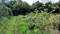
17 Aug 2023A mix of urban, open space and field paths some rather tightly enclosed. Shops and buses at Hemingfield about half way.
I started from Wombwell with a stretch of pavement walking which leads to but then avoids Wombwell Park using instead an enclosed but decent path alongside the golf course.
A zig-zag leads to a bridge under what sounded like a busy dual carriageway and we are soon into Hemingfield where there were a few shops and a cafe.
The next paths had recently had vegetation cut back but I wondered whether it would have been better to offer a link onto estate roads rather than the long enclosed path around the development perimeter.
Escaping into wider spaces the route heads off along a track and under the railway viaduct then along Vizard Road a surface of concrete slabs that reminded me of wartime airfields. Jump Valley is a popular local recreation destination, as such there are many paths so the plot which follows the definitive line will not assist you. A well walked path climbs the hill until a school fence appears on the left, follow this to the road.
The final approach to Hoyland is easy along a road and the meeting place offers seats and all services.
Share your views about this route, give it a star rating, indicate whether it should be verified or not.
Include information that will be useful to others considering to walk or wheel it.
You can add up to 15 photos.
There are no other routes for Hoyland — Wombwell
If you know a better way, then please let us know.
Review this better route and help establish a trusted network of walking routes.
Suggest a better route if it better meets our methodology.
Share your thoughts