Description
From Fairmilehead cross roads turn right into Comiston Road and shortly afterwards turn right into a pedestrian lane. This leads into Bellrock Park which should be followed round to the left. Waterfield Road on the right leads into the Waterboard Field (Brough Park). This whole area used to be a large waterworks that supplied Edinburgh. Follow the path across the park and turn into Buckstone Howe. Turn left for a short distance and go through Buckstone Park. At the end turn right onto a track through the woods. This emerges from an avenue of yew trees into open paddocks and should be followed till it branches left. Follow the track through a little wood and after a cottage turn left. Keep going past Meadowhead Farm till Braid Hills Drive is reached. Just before the road, turn left to follow a bridle way through a wood on the edge of the golf course. When it reaches the road, cross the road. The bridle way is well used by horses and cyclists and so can be muddy. However, there is a pavement on the north side of Braid Hills Drive as an alternative. Either follow the Howe Dean Path (steps) or an informal path to its west (steep and possibly muddy) to meet the main track that goes through the Hermitage of Braid. Cross this track and take a path up some steps. This leads to a track through a community woodland on the site of an old quarry. This should be followed to the top (there are several possible paths) from where a path leads to the Royal Observatory on Blackford Hill. Follow a path on its east side. Turn right down the steep Observatory Road and take the first left into Blackford Hill Rise which snakes down to Ladysmith Road. Turn left and you arrive at a major cross roads. Cross over into Blackford Avenue which passes over a railway line then take the second right into West Relugas Road. Take the first left then cross over and keep going to a T-junction. On the far side a gate post surmounted by a griffon marks the start of Lover's Loan, which can be followed all the way to Sciennes Road. Turn left and right and cross over to Middle Meadow Walk. Faiedi1 can be followed all the way to Waverley station from here. However, as an alternative turn right at a junction and then left into George Square. This can be followed on either side or, if the gates are open, through the garden in the centre. Diagonally opposite where you come into the square, turn left towards Bristo Square. George Square is a mix of Georgian houses and more modern university buildings. Watch out for the rhinoceros! Go through the underpass under Potterrow and turn into West College Street . On the right is a door into the University of Edinburgh Old Quad, which is worth a look. Continue across Chambers Street then down steps into the Cowgate. Turn left and right into old Fishmarket Close, which is steep and is cobbled. This leads to the High Street. Turn left past St Giles and descend Advocates Close (more steps). This leads to Cockburn Street, which is a short distance from Waverley Station
From Fairmilehead cross roads turn right into Comiston Road and shortly afterwards turn right into a pedestrian lane. This leads into Bellrock Park which should be followed round to the left. Waterfield Road on the right leads into the Waterboard Field (Brough Park). This whole area used to be a large waterworks that supplied Edinburgh. Follow the path across the park and turn into Buckstone Howe. Turn left for a short distance and go through Buckstone Park. At the end turn right onto a track through the woods. This emerges from an avenue of yew trees into open paddocks and should be followed till it branches left. Follow the track through a little wood and after a cottage turn left. Keep going past Meadowhead Farm till Braid Hills Drive is reached. Just before the road, turn left to follow a bridle way through a wood on the edge of the golf course. When it reaches the road, cross the road. The bridle way is well used by horses and cyclists and so can be muddy. However, there is a pavement on the north side of Braid Hills Drive as an alternative. Either follow the Howe Dean Path (steps) or an informal path to its west (steep and possibly muddy) to meet the main track that goes through the Hermitage of Braid. Cross this track and take a path up some steps. This leads to a track through a community woodland on the site of an old quarry. This should be followed to the top (there are several possible paths) from where a path leads to the Royal Observatory on Blackford Hill. Follow a path on its east side. Turn right down the steep Observatory Road and take the first left into Blackford Hill Rise which snakes down to Ladysmith Road. Turn left and you arrive at a major cross roads. Cross over into Blackford Avenue which passes over a railway line then take the second right into West Relugas Road. Take the first left then cross over and keep going to a T-junction. On the far side a gate post surmounted by a griffon marks the start of Lover's Loan, which can be followed all the way to Sciennes Road. Turn left and right and cross over to Middle Meadow Walk. Faiedi1 can be followed all the way to Waverley station from here. However, as an alternative turn right at a junction and then left into George Square. This can be followed on either side or, if the gates are open, through the garden in the centre. Diagonally opposite where you come into the square, turn left towards Bristo Square. George Square is a mix of Georgian houses and more modern university buildings. Watch out for the rhinoceros! Go through the underpass under Potterrow and turn into West College Street . On the right is a door into the University of Edinburgh Old Quad, which is worth a look. Continue across Chambers Street then down steps into the Cowgate. Turn left and right into old Fishmarket Close, which is steep and is cobbled. This leads to the High Street. Turn left past St Giles and descend Advocates Close (more steps). This leads to Cockburn Street, which is a short distance from Waverley Station
Status
This route has been reviewed by 4 people.
There are no issues flagged.
Photos for Faiedi two


Photos of this route will appear when they are added to a review. You can review this route here.
Information
")
Route status - Live
Reviews - 4
Average rating -
Is this route good enough? - Yes (4)
There are currently no problems reported with this route.
Downloads - 2
Surveys
We are working to build-up a picture of what routes look like. To do that we are asking volunteers to survey routes so that we can communicate features, obstacles and challenges that may make a route desirable or not.
Slow Ways surveyors are asked to complete some basic online training, but they are not vetted. If you are dependent on the survey information being correct in order to complete a route, we recommend that you think critically about the information provided. You may also wish to wait until more than one survey has been completed.
Help people know more about this route by volunteering to submit a survey.
- Complete the survey training.
- Submit a survey for this route.
Geography information system (GIS) data
Total length
Maximum elevation
Minimum elevation
Start and end points
Fairmilehead
Grid Ref
NT2483568230
Lat / Lon
55.90129° / -3.20370°
Easting / Northing
324,835E / 668,230N
What3Words
truck.mimic.smoke
Edinburgh
Grid Ref
NT2569673813
Lat / Lon
55.95157° / -3.19147°
Easting / Northing
325,696E / 673,813N
What3Words
shape.pads.choice
| Fairmilehead | |
|---|---|
| Grid Ref | NT2483568230 |
| Lat / Lon | 55.90129° / -3.20370° |
| Easting / Northing | 324,835E / 668,230N |
| What3Words | truck.mimic.smoke |
| Edinburgh | |
|---|---|
| Grid Ref | NT2569673813 |
| Lat / Lon | 55.95157° / -3.19147° |
| Easting / Northing | 325,696E / 673,813N |
| What3Words | shape.pads.choice |
Sorry Land Cover data is not currently available for this route. Please check back later.
reviews
JoB
17 Feb 2024I decided to walk Faledi two in a loop with Faledi one, walking Faledi one in reverse. From Waverley Station my inverted route started with a climb up onto the Mound. You can follow the road up to the Lawnmarket but there are also cut through one of the closes.
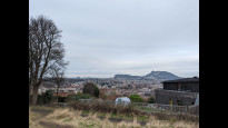
I got a lovely day for it, heading out on George IV Bridge past the National Museum of Scotland to the gentle slope down to the Meadows. Faledi two (reversed) went out almost straight through Marchmont to Blackford Hill. It was a steep climb up the streets up to the top of the hill, at the top the road gave out and I stood beside the Observatory with Edinburgh stretched out below me in the sun.
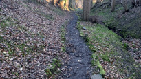
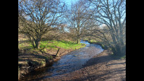
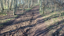
Beyond the Observatory navigation down the far side of Blackford Hill heading towards the Braid Hills became a little tricky as there are a maze of paths but keeping an eye on my OS map app kept me heading in the right direction. Off the roads the paths were a little muddy that day, a sprinkling of snow was still on the ground, but I found my way down through the trees among chattering birdsong to the bridge across the Braid Burn.
Then came a steep climb up through trees alongside a stream to Braid Hills Drive and another set of fantastic views: Edinburgh behind and a cold wind coming down from the Pentland Hills ahead of me. A path through the woods to the side of the road lead to the impressive Liberton Tower and I turned right onto the farm track snaking alongside the golf course and past Meadowhead Farm. I was surprised at how rural this SlowWay felt, surrounded as it was on all sides by the City. Fields sloped down to the side of me , an unbothered squirrel watched me from the woods munching on a nut and all I could hear were birds.
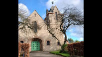
At Mortonhall Caravan Park the path twisted through parkland, the tracks here were filled with people out for a stroll and Faledi two turned urban again. The final part of the route was through a modern housing estate of enormous houses where I came out onto the main road to the finishing point at Fairmilehead Church. I contentedly sat and munched my lunch before taking Faiedi one back towards the city centre.
I would very happily walk this route again, it was uncomplicated to follow and I didn't expect a city walk to feel like I was out in the countryside away from people, but it did. The way over Blackford and Braid Hills make it accessible only to walkers or mountain bikers and you would need decent shoes but in terms of navigation I found it reasonably unchallenging if I was keeping an eye on my OS mapping app. There were no access issues in terms of paths or roads being blocked.
Ewan davidson
26 Feb 2022This is a very scenic but also quite undulating route into the town centre. Its worth paying careful attention to the directions at the start of the route ( skirting a suburban housing scheme) and pointing out that the left turn mentioned beyond yew tree avenue is at a quadrangle block which contains a cafe. Path beside braid hills road is indeed muddy (shared with mountain bikes, ponies and joggers) but there is a pavement on the other side of the road, and it is a steep climb over blackford hill . Lovers Lane is curious but also very secluded with poor sightlines and might be a little scary (although easily avoided).
-
Share your thoughts
Ben
30 Jan 2022Chose this route as it took me along paths I'd never used. That long straight path through the Grange and Sciennes was a revelation. Really enjoyed the route.
-
Share your thoughts
Afm
09 Jun 2021Lovely route avoiding the busiest roads in the area. Cut through into Buckstone and into Mortonhall is lovely and particularly love the alleyways through Marchmont missing out the worst of the streets.
-
Share your thoughts
Share your views about this route, give it a star rating, indicate whether it should be verified or not.
Include information that will be useful to others considering to walk or wheel it.
You can add up to 15 photos.
Other Routes for Fairmilehead—Edinburgh See all Slow Ways
Review this better route and help establish a trusted network of walking routes.
Suggest a better route if it better meets our methodology.
Share your thoughts