Description
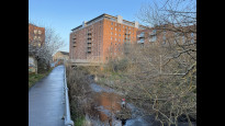
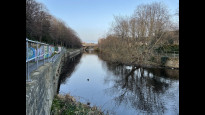
This Slow Way will get you from Edinburgh to Leith. It's a variation on Edileigh two and is slightly flatter leaving Edinburgh to McDonald Road. The section through St Marks Park skirts closer to the Water of Leith and takes you through a tunnel. There are also sections with steps which makes it unsuitable for wheels
This Slow Way will get you from Edinburgh to Leith. It's a variation on Edileigh two and is slightly flatter leaving Edinburgh to McDonald Road. The section through St Marks Park skirts closer to the Water of Leith and takes you through a tunnel. There are also sections with steps which makes it unsuitable for wheels
Status
This route has been reviewed by 2 people.
There are no issues flagged.
Photos for Edilei four


Photos of this route will appear when they are added to a review. You can review this route here.
Information

Route status - Live
Reviews - 2
Average rating -
Is this route good enough? - Yes (2)
There are currently no problems reported with this route.
Downloads - 4
Surveys
We are working to build-up a picture of what routes look like. To do that we are asking volunteers to survey routes so that we can communicate features, obstacles and challenges that may make a route desirable or not.
Slow Ways surveyors are asked to complete some basic online training, but they are not vetted. If you are dependent on the survey information being correct in order to complete a route, we recommend that you think critically about the information provided. You may also wish to wait until more than one survey has been completed.
Help people know more about this route by volunteering to submit a survey.
- Complete the survey training.
- Submit a survey for this route.
Geography information system (GIS) data
Total length
Maximum elevation
Minimum elevation
Start and end points
Edinburgh
Grid Ref
NT2569673813
Lat / Lon
55.95157° / -3.19147°
Easting / Northing
325,696E / 673,813N
What3Words
shape.pads.choice
Leith
Grid Ref
NT2697376403
Lat / Lon
55.97503° / -3.17173°
Easting / Northing
326,973E / 676,403N
What3Words
with.wants.manage
| Edinburgh | |
|---|---|
| Grid Ref | NT2569673813 |
| Lat / Lon | 55.95157° / -3.19147° |
| Easting / Northing | 325,696E / 673,813N |
| What3Words | shape.pads.choice |
| Leith | |
|---|---|
| Grid Ref | NT2697376403 |
| Lat / Lon | 55.97503° / -3.17173° |
| Easting / Northing | 326,973E / 676,403N |
| What3Words | with.wants.manage |
Sorry Land Cover data is not currently available for this route. Please check back later.
Other Routes for Edinburgh—Leith See all Slow Ways
Review this better route and help establish a trusted network of walking routes.
Suggest a better route if it better meets our methodology.