Description
This Slow Way will get you from Edinburgh to Leith. It's a variation on Edileigh two and is slightly flatter leaving Edinburgh to McDonald Road. The section through St Marks Park skirts closer to the Water of Leith and takes you through a tunnel. There are also sections with steps which makes it unsuitable for wheels
This Slow Way will get you from Edinburgh to Leith. It's a variation on Edileigh two and is slightly flatter leaving Edinburgh to McDonald Road. The section through St Marks Park skirts closer to the Water of Leith and takes you through a tunnel. There are also sections with steps which makes it unsuitable for wheels
Status
This route has been reviewed by 2 people.
There are no issues flagged.
Photos for Edilei four


Photos of this route will appear when they are added to a review. You can review this route here.
Information

Route status - Live
Reviews - 2
Average rating -
Is this route good enough? - Yes (2)
There are currently no problems reported with this route.
Downloads - 4
Surveys
We are working to build-up a picture of what routes look like. To do that we are asking volunteers to survey routes so that we can communicate features, obstacles and challenges that may make a route desirable or not.
Slow Ways surveyors are asked to complete some basic online training, but they are not vetted. If you are dependent on the survey information being correct in order to complete a route, we recommend that you think critically about the information provided. You may also wish to wait until more than one survey has been completed.
Help people know more about this route by volunteering to submit a survey.
- Complete the survey training.
- Submit a survey for this route.
Geography information system (GIS) data
Total length
Maximum elevation
Minimum elevation
Start and end points
Edinburgh
Grid Ref
NT2569673813
Lat / Lon
55.95157° / -3.19147°
Easting / Northing
325,696E / 673,813N
What3Words
shape.pads.choice
Leith
Grid Ref
NT2697376403
Lat / Lon
55.97503° / -3.17173°
Easting / Northing
326,973E / 676,403N
What3Words
with.wants.manage
| Edinburgh | |
|---|---|
| Grid Ref | NT2569673813 |
| Lat / Lon | 55.95157° / -3.19147° |
| Easting / Northing | 325,696E / 673,813N |
| What3Words | shape.pads.choice |
| Leith | |
|---|---|
| Grid Ref | NT2697376403 |
| Lat / Lon | 55.97503° / -3.17173° |
| Easting / Northing | 326,973E / 676,403N |
| What3Words | with.wants.manage |
Sorry Land Cover data is not currently available for this route. Please check back later.
reviews
MartinF
27 Feb 2024 (edited 28 Feb 2024)I walked this route in late afternoon in late February. It's a good route, I really have no concerns or criticisms. Only 4 stars from me mainly because I prefer the quieter, more picturesque streets of Edilei Two, but I completely agree with the author of Edilei Four that it is needed to provide a less steep alternative for the start of the walk.
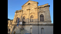
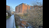
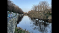
The first part of the walk is down some very busy streets, but the pavements are wide, and the pedestrian crossings are plentiful, so it's straightforward to navigate. Plus you get to admire the amazing traffic management at Picardy Place - somehow trams, motor vehicles, bikes and pedestrians all manage to navigate safely round a very complex junction. There are plenty of shops, bars, cafes and restaurants in this first section. After a while, the route turns left down McDonald Road, a quieter residential street, then into St Mark's Park, where a right turn takes you onto the Water of Leith walkway. This path is a bit rougher and sometimes muddy - bikes or wheelchairs might be better advised to keep straight on and meet up with Edilei Two. There's a tunnel which floods after heavy rain, but it was clear when I walked it.
I love the Water of Leith walkway, it winds along the river bank for around 13 miles from Balerno to Leith, passing through some old parts of the city which are often overlooked today. The path is generally good, often excellent, although there are still occasional steps. Edilei Four suffers from one set of steps at Newhaven Road, which you can avoid by sticking on Edilei Two and following the Warriston Path (aka National Cycle Route 75) into Leith.
Short-term, there are some works which have closed the path completely at Coburg Street. These started on 25 Nov 2023, and are scheduled to last for 25 weeks. There's an short detour via Coburg Street, but that involves a significant flight of steps. I believe you can avoid all that by crossing the Water of Leith at West Bowling Green Street, turning left on the path on the East side of the river, then take Mill Lane, Sherriff Brae and Coalhill into Leith. Unfortunately it was getting dark, so I didn't have time to go back and check that out.
Hiking Historian
21 Jun 2023Walked in reverse.
From Leith, the route takes us along the Water of Leith for most of the way. Mostly good tarmacced paths, it crosses the river at many places before we climb to the road in Bonnington. From there we access the old railway path via going down a few steps, before we join the riverside path once more. Over a bridge, we finally meet paved roads, passing through residential areas before heading past the Omni multiplex and eventually arriving at Waverley.
A good riverside wander, but there's quite a few steps, which would exclude some users.
-
Share your thoughts
Share your views about this route, give it a star rating, indicate whether it should be verified or not.
Include information that will be useful to others considering to walk or wheel it.
You can add up to 15 photos.
Other Routes for Edinburgh—Leith See all Slow Ways
Review this better route and help establish a trusted network of walking routes.
Suggest a better route if it better meets our methodology.
Share your thoughts