Description
This is a Slow Ways route connecting Dorking and Leatherhead.
Know of a better route? Share it here.
This is a Slow Ways route connecting Dorking and Leatherhead.
Know of a better route? Share it here.
Status
This route has been reviewed by 5 people.
There are no issues flagged.
Photos for Dorlea one


Photos of this route will appear when they are added to a review. You can review this route here.
Information
")
Route status - Live
Reviews - 5
Average rating -
Is this route good enough? - Yes (5)
There are currently no problems reported with this route.
Downloads - 17
Surveys
What is this route like?
Surveys are submitted by fellow users of this website and show what you might expect from this Slow Ways route. Scroll down the page to read more detailed surveys.
| Grade 4X based on 1 surveys | Sign up or log in to survey this route. | ||
|---|---|---|---|
| Description | Note | ||
| Grade 4: Route includes very rough surfaces including deep ruts, steep loose gravel, unmade paths and deep muddy sections. Wheelchairs may experience traction/wheel spin issues. Access grade X: At least one stile, flight of steps or other obstacle that is highly likely to block access for wheelchair and scooter users. |
Grading is based on average scores by surveyors. This slow way has 1 surveys. | ||
| Full grading description | |||
Only people who have completed our training can become Slow Ways surveyors and submit a survey. We do not vet contributors, so we cannot guarantee the quality or completeness of the surveys they complete. If you are dependent on the information being correct we recommend reading and comparing surveys before setting off.
Survey Photos
Facilities
Facilities in the middle third of this route.
Challenges
Potential challenges reported on this route. Some challenges are seasonal.
Obstacles
Obstacles on this route.
Accessibility
Is this route step and stile free?
Measurements
Surveyors were asked to measure the narrowest and steepest parts of paths.
The narrowest part of the path is 50.0cm (1)
The steepest uphill gradient walking East 20.0% (1)
The steepest uphill gradient walking West 32.0% (1)
The steepest camber gradient across the path 7.0% (1)
How clear is the waymarking on the route: Unclear in places (1)
Successfully completed
We asked route surveyors "Have you successfully completed this route with any of the following? If so, would you recommend it to someone with the same requirements?". Here is how they replied.
Recommended by an expert
We asked route surveyors "Are you a trained access professional, officer or expert? If so, is this route suitable for someone travelling with any of the following?" Here is how they replied.
Terrain
We asked route surveyors to estimate how much of the route goes through different kinds of terrain.
17.0% of the route is on roads (1)
20.0% of the route is lit at night (1)
20.0% of the route is paved (1)
20.0% of the route is muddy (1)
15.0% of the route is over rough ground (1)
10.0% of the route is through long grass (1)
Report a problem with this data
1 surveys
Information from verified surveys.
Geography information system (GIS) data
Total length
Maximum elevation
Minimum elevation
Start and end points
Dorking
Grid Ref
TQ1643549288
Lat / Lon
51.23091° / -0.33373°
Easting / Northing
516,435E / 149,288N
What3Words
tinsel.chimp.motion
Leatherhead
Grid Ref
TQ1629156856
Lat / Lon
51.29896° / -0.33333°
Easting / Northing
516,291E / 156,856N
What3Words
earth.leap.cycles
Dorlea One's land is
| Dorking | |
|---|---|
| Grid Ref | TQ1643549288 |
| Lat / Lon | 51.23091° / -0.33373° |
| Easting / Northing | 516,435E / 149,288N |
| What3Words | tinsel.chimp.motion |
| Leatherhead | |
|---|---|
| Grid Ref | TQ1629156856 |
| Lat / Lon | 51.29896° / -0.33333° |
| Easting / Northing | 516,291E / 156,856N |
| What3Words | earth.leap.cycles |
| Arable | 9.4% |
| Pasture | 45.2% |
| Urban | 37.1% |
| Woods | 8.3% |
Data: Corine Land Cover (CLC) 2018
reviews
Strider
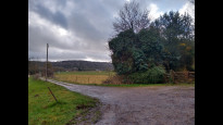
19 Feb 2023I walked from Dorking to Leatherhead.
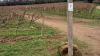
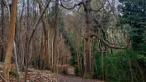
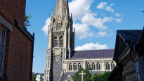
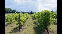
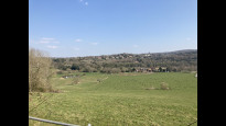
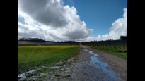
This is a lovely walk. Past the church in Dorking and quickly into open countryside. Huge vineyard to start with open skies then down a narrow passage through Westhumble. Then parallel to the rail and the River Mole. You follow the Mole Gap Trail, the signs are stainless steel embedded in posts, bridges and even the road tarmac, very nice but hard to spot sometimes. Through livestock fields with livestock and mud. Then into a beautiful woodland on a hillside.
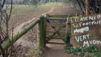
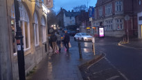
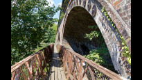
Here there is an mapping error, you have to go down a steep hill, over then under the rail line. The turning is marked in steel in the road tarmac, follow the sign not the map (see picture).
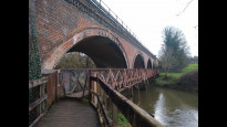
Keep following the Mole and the signs all the way to Leatherhead and cross the bridge to the town centre.
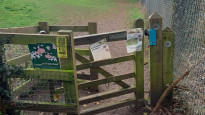
Lots of stiles, gates, kissing gates, mud and bridges, not suitable for wheels.
I agree with the previous reviewers a very nice varied walk with views and waterside paths.
Derick Rethans
28 Aug 2022I walked this on a warm overcast Saturday afternoon from Dorking to Leatherhead.
It's a delightful walk along the river Mole and through Denby's wine estate. There are quite a few stiles, but the route, although it has some steep parts, is easy enough. I am giving it 4 stars due to a little more town walking in Dorking that I was happy with.
-
Share your thoughts
Christopher Brown
25 Mar 2022Nice fairly steady walk. Only a couple of steeper parts but nothing unmanageable, plenty of scenic views. Picnic spot in the middle and a number of pubs near the route if you need a refreshment stop! Follows the Mole Gap Trail which is well signposted.
-
Share your thoughts
Ingrina
14 Mar 2022A lot of this route is through open fields, so in the winter/early spring might be quite muddy and slippery. Would recommend boots with good grip rather than trying to take alternatives. But there are some really nice parts to it that go through woodland and can offer some nice, open views. A lot of gates because it goes through grazing areas, so will not be accessible for those with prams and/or wheelchairs.
-
Share your thoughts
Smatticus1991
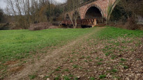
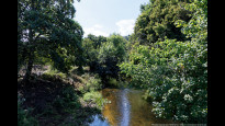
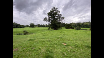
31 Aug 2021This route predominantly follows the “Mole Gap Trail”; a recreational route which follows the River Mole as it bisects the North Downs. Geography aficionados will be interested to see a number of features on route, including the floodplain, meanders, and the severed, dried up remains of an oxbow lake (see picture, though I cannot verify the extent to which this landform has been managed I.e. is it natural or artificial). There are a number of kissing gates which will limit accessibility for disabled users, but the terrain is unchallenging. While it should go without saying, I would advise all dog walkers to keep their dogs under close control, as the route skirts around and transits through a number of fields actively being used for grazing. Overall, a relatively easy, scenic route which links two significant towns in the Surrey Hills area and offers a nice alternative to the numerous transport links between them. Happy to verify.
-
Share your thoughts
Share your views about this route, give it a star rating, indicate whether it should be verified or not.
Include information that will be useful to others considering to walk or wheel it.
You can add up to 15 photos.
There are no other routes for Dorking — Leatherhead
If you know a better way, then please let us know.
Review this better route and help establish a trusted network of walking routes.
Suggest a better route if it better meets our methodology.
Share your thoughts