Chesterfield — Staveley (Derbyshire)
Chesta two

Verified Slow Way
Verified by 100.00% of reviewers
Verified Slow Way
Verified by 100.00% of reviewers
By Cambo on 24 Apr 2021
Description
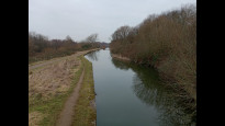
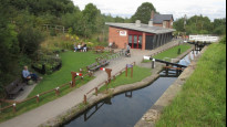
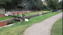
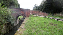
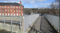
Chesterfield to staveley along the well established canal towpath and river rother. all on graveled path with canal trust shop and canal trust cafe at along the route. fully signposted as part of the cookoo way and NCN route 67
apart from the start and end point which are in built up areas the only roads on the route are crossable via bridges/tunnels
Status
This route has been reviewed by 4 people.
There are no issues flagged.
Photos for Chesta two


Photos of this route will appear when they are added to a review. You can review this route here.
Information
Route status - Live
Reviews - 4
Average rating -
Is this route good enough? - Yes (4)
There are currently no problems reported with this route.
Downloads - 8
Surveys
We are working to build-up a picture of what routes look like. To do that we are asking volunteers to survey routes so that we can communicate features, obstacles and challenges that may make a route desirable or not.
Slow Ways surveyors are asked to complete some basic online training, but they are not vetted. If you are dependent on the survey information being correct in order to complete a route, we recommend that you think critically about the information provided. You may also wish to wait until more than one survey has been completed.
Help people know more about this route by volunteering to submit a survey.
- Complete the survey training.
- Submit a survey for this route.
Geography information system (GIS) data
Total length
Maximum elevation
Minimum elevation
Start and end points
Chesterfield
Grid Ref
SK3850071140
Lat / Lon
53.23592° / -1.42464°
Easting / Northing
438,500E / 371,140N
What3Words
silly.shall.hook
Staveley (Derbyshire)
Grid Ref
SK4324874600
Lat / Lon
53.26667° / -1.35304°
Easting / Northing
443,248E / 374,601N
What3Words
tribes.stay.kinds
| Chesterfield | |
|---|---|
| Grid Ref | SK3850071140 |
| Lat / Lon | 53.23592° / -1.42464° |
| Easting / Northing | 438,500E / 371,140N |
| What3Words | silly.shall.hook |
| Staveley (Derbyshire) | |
|---|---|
| Grid Ref | SK4324874600 |
| Lat / Lon | 53.26667° / -1.35304° |
| Easting / Northing | 443,248E / 374,601N |
| What3Words | tribes.stay.kinds |
Sorry Land Cover data is not currently available for this route. Please check back later.
Other Routes for Chesterfield—Staveley (Derbyshire) See all Slow Ways
Review this better route and help establish a trusted network of walking routes.
Suggest a better route if it better meets our methodology.