Chesterfield — Staveley (Derbyshire)
Chesta two

Verified Slow Way
Verified by 100.00% of reviewers
Verified Slow Way
Verified by 100.00% of reviewers
By Cambo on 24 Apr 2021
Description
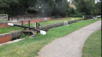
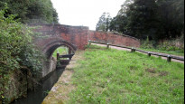
Chesterfield to staveley along the well established canal towpath and river rother. all on graveled path with canal trust shop and canal trust cafe at along the route. fully signposted as part of the cookoo way and NCN route 67
apart from the start and end point which are in built up areas the only roads on the route are crossable via bridges/tunnels
Status
This route has been reviewed by 4 people.
There are no issues flagged.
Photos for Chesta two


Photos of this route will appear when they are added to a review. You can review this route here.
Information
Route status - Live
Reviews - 4
Average rating -
Is this route good enough? - Yes (4)
There are currently no problems reported with this route.
Downloads - 8
Surveys
We are working to build-up a picture of what routes look like. To do that we are asking volunteers to survey routes so that we can communicate features, obstacles and challenges that may make a route desirable or not.
Slow Ways surveyors are asked to complete some basic online training, but they are not vetted. If you are dependent on the survey information being correct in order to complete a route, we recommend that you think critically about the information provided. You may also wish to wait until more than one survey has been completed.
Help people know more about this route by volunteering to submit a survey.
- Complete the survey training.
- Submit a survey for this route.
Geography information system (GIS) data
Total length
Maximum elevation
Minimum elevation
Start and end points
Chesterfield
Grid Ref
SK3850071140
Lat / Lon
53.23592° / -1.42464°
Easting / Northing
438,500E / 371,140N
What3Words
silly.shall.hook
Staveley (Derbyshire)
Grid Ref
SK4324874600
Lat / Lon
53.26667° / -1.35304°
Easting / Northing
443,248E / 374,601N
What3Words
tribes.stay.kinds
| Chesterfield | |
|---|---|
| Grid Ref | SK3850071140 |
| Lat / Lon | 53.23592° / -1.42464° |
| Easting / Northing | 438,500E / 371,140N |
| What3Words | silly.shall.hook |
| Staveley (Derbyshire) | |
|---|---|
| Grid Ref | SK4324874600 |
| Lat / Lon | 53.26667° / -1.35304° |
| Easting / Northing | 443,248E / 374,601N |
| What3Words | tribes.stay.kinds |
Sorry Land Cover data is not currently available for this route. Please check back later.
reviews
StephenWalker
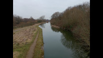
23 Aug 2023I followed this route from Staveley, the last leg of a Chesterfield - Bolsover- Staveley - Chesterfield circular walk. I enjoyed the route throughout, despite the unattractive entry to Chesterfield itself. There were refreshments and canal-related information available at Hollingwood Lock. The tow-path walk is a pleasant route in itself.
Paul.scholey
13 Mar 2023Reviewed on 17th Feb 2023. A pleasant, straightforward walk along canal towpaths between Chesterfield and Staveley, largely following the route of the the Cuckoo Way once the canal path is joined having descended down from Chesterfield town centre.
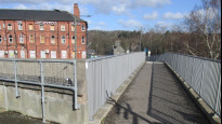
There are a couple of awkward navigation moments as you follow the back streets through Chesterfield, crossing above the busy A61 and then crossing a number of smaller, but busy roads near Chesterfield train station but after that the navigation is easy.
The only negative is the first, short stretch along the canal until you reach Tapton Lock is blighted by rubbish and hemmed in between housing developments - but it improves substantially after Tapton Lock.
-
Share your thoughts
Andrew Sheldon
18 Feb 2023A near-perfect Slow Way joining Chesterfield and Staveley, almost entirely along the Chesterfield Canal.
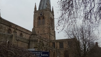
I walked this route on a Sunday morning and, as a result, found it reasonably busy with large numbers of walkers, cyclists and dogs out in surprisingly balmy February weather. Apart from the two ends of the route - getting on to and off the the canal - navigation is a non-issue as the track follows the canal. You might make a case for the Slow Way starting/ending at Chesterfield Railway Station rather than outside the Crooked Spire but there's very little in it.
Overall, it's a route I've walked before and would walk again and would thoroughly recommend to others.
Unequivocally a 5-star route.
-
Share your thoughts
Ken
27 Mar 2022I walked this easy and safe route midweek, shared with cycles and waterside. Highly recommended well plotted easy to follow.
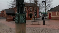
From Staveley Market Place with it's statue / sculpture marking the history of the town it's a short walk to join the Chesterfield canal which is followed all the way.
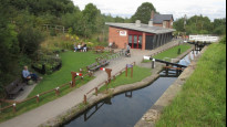
Hollingwood Hub is a great spot for a break bring your own and sit outside or buy a drink. Also an information centre for the Chesterfield Canal Trust. The Mill Inn at Brimington and Tapton Visitor Centre could also offer refreshment. Tapton House was the home of railway engineer and industrialist George Stephenson who is buried in Chesterfield.
South of Tapton the cycle route leaves the canal so from here the path is not so well maintained but still well used by walkers. Entering Chesterfield the route passes close to the railway station before making a safe footbridge crossing of the busy bypass to arrive at the Crooked Spire and the meeting place.
-
Share your thoughts
Share your views about this route, give it a star rating, indicate whether it should be verified or not.
Include information that will be useful to others considering to walk or wheel it.
You can add up to 15 photos.
Other Routes for Chesterfield—Staveley (Derbyshire) See all Slow Ways
Review this better route and help establish a trusted network of walking routes.
Suggest a better route if it better meets our methodology.
Share your thoughts