Burgess Hill — Uckfield
Buruck three

Slow Way not verified yet. Verify Buruck here.
Slow Way not verified yet. Verify Buruck here.
By Bostal Boy on 18 May 2023
Description
This is a third BURUCK using a more southerly route through Ditchling Common, past the Plough pub at Plumpton Green then past Chailey Church to meet up with the two previous BURUCKs at Newick. This avoids the road walking along North Common Road at Wivelsfield Green. I pioneered this route on 18th May 2023. I will add a full review
This is a third BURUCK using a more southerly route through Ditchling Common, past the Plough pub at Plumpton Green then past Chailey Church to meet up with the two previous BURUCKs at Newick. This avoids the road walking along North Common Road at Wivelsfield Green. I pioneered this route on 18th May 2023. I will add a full review
Status
This route has been reviewed by 1 person.
There are no issues flagged.
Photos for Buruck three


Photos of this route will appear when they are added to a review. You can review this route here.
Information
Route status - Live
Reviews - 1
Average rating -
Is this route good enough? - Yes (1)
There are currently no problems reported with this route.
Downloads - 0
Surveys
We are working to build-up a picture of what routes look like. To do that we are asking volunteers to survey routes so that we can communicate features, obstacles and challenges that may make a route desirable or not.
Slow Ways surveyors are asked to complete some basic online training, but they are not vetted. If you are dependent on the survey information being correct in order to complete a route, we recommend that you think critically about the information provided. You may also wish to wait until more than one survey has been completed.
Help people know more about this route by volunteering to submit a survey.
- Complete the survey training.
- Submit a survey for this route.
Geography information system (GIS) data
Total length
Maximum elevation
Minimum elevation
Start and end points
Burgess Hill
Grid Ref
TQ3162618821
Lat / Lon
50.95379° / -0.12737°
Easting / Northing
531,626E / 118,821N
What3Words
snowmen.protected.leathers
Uckfield
Grid Ref
TQ4728320885
Lat / Lon
50.96856° / 0.09623°
Easting / Northing
547,283E / 120,885N
What3Words
disarmed.waistcoat.unlocking
| Burgess Hill | |
|---|---|
| Grid Ref | TQ3162618821 |
| Lat / Lon | 50.95379° / -0.12737° |
| Easting / Northing | 531,626E / 118,821N |
| What3Words | snowmen.protected.leathers |
| Uckfield | |
|---|---|
| Grid Ref | TQ4728320885 |
| Lat / Lon | 50.96856° / 0.09623° |
| Easting / Northing | 547,283E / 120,885N |
| What3Words | disarmed.waistcoat.unlocking |
Sorry Land Cover data is not currently available for this route. Please check back later.
review
Bostal Boy
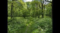
18 May 2023I walked this on a sunny day in May. I found this route to be really peaceful, often completely away from any road noise. It mainly follows field paths and woodland tracks with a short section of road walking along Beresford Lane near the Plough Pub. This really showcases how attractive the Low Weald clay country can be with lots of small fields, hedgerows and patches of woodland, occasionally with glimpses of the South Downs to the South. This is an actively farmed landscape with fields containing cattle and sheep and some arable so I encountered paths alongside and through crops, mowed hay and fields which had been recently ploughed. There are numerous stiles, gates and footbridges to negotiate. Oh, and one of the fields I passed was home to two bactrian camels (you are not allowed to walk through their field!).
The route passes close by to The Plough at Plumpton Green which has a memorial in the garden to Polish squadrons who flew from a nearby airfield in WW2. There are several pubs, plus a bakery and a village shop at Newick, a short diversion off the route from Newick Church. The two churches at Chailey and Newick are attractive with quiet benches in the churchyards to take a rest.
Overall this is quite an energetic walk which took me about 5 and a half hours with a couple of stops. Some of the paths were still quite muddy after a particularly wet winter and early spring in 2023 so boots are a must. Not suitable for wheels.
Share your views about this route, give it a star rating, indicate whether it should be verified or not.
Include information that will be useful to others considering to walk or wheel it.
You can add up to 15 photos.
Other Routes for Burgess Hill—Uckfield See all Slow Ways
Review this better route and help establish a trusted network of walking routes.
Suggest a better route if it better meets our methodology.
Share your thoughts