Description
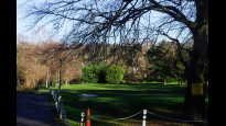
Between Beckenham and Shortlands Station the way is along well-heeled and relatively quiet roads. Part is unadopted with rather rougher surfaces, some potholes. Crossing the A222 between the two parts of the route (near Shortlands Station) is problematic but there is a zebra crossing a few hundred metres east from where the footpath towards Bromley turns south east. That footpath runs above the River Ravensbourne which the route then follows, mostly through a chain of small parks.
There are shops, a cafe and a chip shop plus bus stops near Shortlands Station, midroute. Queensmead Rec has no gates to lock but the Thames Water path/ribbon park starting at Glassmill Lane and possibly also Church House Gardens should be locked at night. A lady dog walker was not convinced this happens in practice. https://www.bromley.gov.uk/parksopeningtimes
There are plenty of shops and transport options at either end. Community toilets in Bromley at The Glades shopping centre, in Beckenham at Waitrose or M&S Food.
(Uploaded 16 Dec 2024, edit 20 Jan 2024 to reflect JMs point about the road crossing.)
Status
This route has been reviewed by 3 people.
There are no issues flagged.
Photos for Beckbro one


Photos of this route will appear when they are added to a review. You can review this route here.
Information
")
Route status - Live
Reviews - 3
Average rating -
Is this route good enough? - Yes (3)
There are currently no problems reported with this route.
Downloads - 4
Surveys
We are working to build-up a picture of what routes look like. To do that we are asking volunteers to survey routes so that we can communicate features, obstacles and challenges that may make a route desirable or not.
Slow Ways surveyors are asked to complete some basic online training, but they are not vetted. If you are dependent on the survey information being correct in order to complete a route, we recommend that you think critically about the information provided. You may also wish to wait until more than one survey has been completed.
Help people know more about this route by volunteering to submit a survey.
- Complete the survey training.
- Submit a survey for this route.
Geography information system (GIS) data
Total length
Maximum elevation
Minimum elevation
Start and end points
Beckenham Junction
Grid Ref
Lat / Lon
51.41047° / -0.02512°
Easting / Northing
0E / 0N
What3Words
brains.scores.spends
Bromley
Grid Ref
TQ4041968709
Lat / Lon
51.40004° / 0.01721°
Easting / Northing
540,419E / 168,709N
What3Words
face.newly.stages
| Beckenham Junction | |
|---|---|
| Grid Ref | |
| Lat / Lon | 51.41047° / -0.02512° |
| Easting / Northing | 0E / 0N |
| What3Words | brains.scores.spends |
| Bromley | |
|---|---|
| Grid Ref | TQ4041968709 |
| Lat / Lon | 51.40004° / 0.01721° |
| Easting / Northing | 540,419E / 168,709N |
| What3Words | face.newly.stages |
Sorry Land Cover data is not currently available for this route. Please check back later.
There are no other routes for Beckenham Junction — Bromley
If you know a better way, then please let us know.
Review this better route and help establish a trusted network of walking routes.
Suggest a better route if it better meets our methodology.