Description
This is a Slow Ways route connecting York and Stamford Bridge.
Know of a better route? Share it here.
This is a Slow Ways route connecting York and Stamford Bridge.
Know of a better route? Share it here.
Status
This route has been reviewed by 4 people.
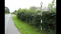
This route has been flagged (1 times) for reasons relating to access.
Photos for Yorsta one

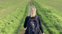


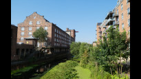
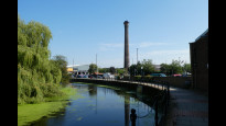


Photos of this route will appear when they are added to a review. You can review this route here.
Information
")
Route status - Live
Reviews - 4
Average rating -
Is this route good enough? - Yes (3) Maybe (1)
Problems reported - Access (1)
Downloads - 29
Surveys
What is this route like?
Surveys are submitted by fellow users of this website and show what you might expect from this Slow Ways route. Scroll down the page to read more detailed surveys.
| Grade 4X based on 3 surveys | Sign up or log in to survey this route. | ||
|---|---|---|---|
| Description | Note | ||
| Grade 3: Route includes rough surfaces that may include small boulders, potholes, shallow ruts, loose gravel, short muddy sections. Access grade X: At least one stile, flight of steps or other obstacle that is highly likely to block access for wheelchair and scooter users. |
Grading is based on average scores by surveyors. This slow way has 3 surveys. | ||
| Full grading description | |||
Only people who have completed our training can become Slow Ways surveyors and submit a survey. We do not vet contributors, so we cannot guarantee the quality or completeness of the surveys they complete. If you are dependent on the information being correct we recommend reading and comparing surveys before setting off.
Survey Photos
Facilities
Facilities in the middle third of this route.
Challenges
Potential challenges reported on this route. Some challenges are seasonal.
Obstacles
Obstacles on this route.
Accessibility
Is this route step and stile free?
Measurements
Surveyors were asked to measure the narrowest and steepest parts of paths.
The narrowest part of the path is 40.0cm (3)
The steepest uphill gradient walking East 10.0% (3)
The steepest uphill gradient walking West 10.0% (3)
The steepest camber gradient across the path 10.0% (3)
How clear is the waymarking on the route: Unclear in places (3)
Successfully completed
We asked route surveyors "Have you successfully completed this route with any of the following? If so, would you recommend it to someone with the same requirements?". Here is how they replied.
Recommended by an expert
We asked route surveyors "Are you a trained access professional, officer or expert? If so, is this route suitable for someone travelling with any of the following?" Here is how they replied.
Terrain
We asked route surveyors to estimate how much of the route goes through different kinds of terrain.
17.5% of the route is on roads (3)
There is no data on how much of this route is lit at night
80.0% of the route is paved (3)
20.0% of the route is muddy (3)
20.0% of the route is over rough ground (3)
15.0% of the route is through long grass (3)
Report a problem with this data
3 surveys
Information from verified surveys.
Geography information system (GIS) data
Total length
Maximum elevation
Minimum elevation
Start and end points
York
Grid Ref
SE5965051750
Lat / Lon
53.95843° / -1.09242°
Easting / Northing
459,650E / 451,750N
What3Words
actual.again.sorters
Stamford Bridge
Grid Ref
SE7125655562
Lat / Lon
53.99122° / -0.91468°
Easting / Northing
471,256E / 455,562N
What3Words
primary.arrow.quote
Yorsta One's land is
| York | |
|---|---|
| Grid Ref | SE5965051750 |
| Lat / Lon | 53.95843° / -1.09242° |
| Easting / Northing | 459,650E / 451,750N |
| What3Words | actual.again.sorters |
| Stamford Bridge | |
|---|---|
| Grid Ref | SE7125655562 |
| Lat / Lon | 53.99122° / -0.91468° |
| Easting / Northing | 471,256E / 455,562N |
| What3Words | primary.arrow.quote |
| Arable | 56.3% |
| Pasture | 8.2% |
| Urban | 35.5% |
Data: Corine Land Cover (CLC) 2018
reviews
Tom
30 May 2023I've run this route twice recently (May 2023), and it's a good route that takes place on mainly quiet roads. My only issue was that some of the proposed route is not accessible due to the way farmland is being used. It's currently not possible to follow the path that runs between Brownhills and Holtby Grange Farm, so the minor detour I chose to take instead was to go directly through Brownhills farm and join Holtby Lane further up. The route also requires you to cross the busy A166 - which I would imagine could present difficulties for someone who isn't able to cross quickly. The route also requires you to negotiate a couple of stiles. Other than that I highly recommend this route, it takes you through some very scenic and quiet farmland with a lot of opportunities to see local wildlife.
Gemma Perry
08 Nov 2022 (edited 02 Nov 2022)My Aviva colleagues and I walked the York to Stamford Bridge In Nov 2022 as part of Aviva’s volunteering scheme. We left the Aviva office at 9:30 and made it to Stamford Bridge by 1:45pm with c30mins break at the lovely Balloon Tree farm shop and Café in Gate Helmsley.
The route starts in York on terrain easy for wheels including a long stretch of pleasant bridleway and plenty of River views, but once it goes out into the fields there are several stiles and fields so not suitable for wheels. One of the stiles was broken and involved climbing over barbed wire.
Someone had helpfully covered the wire in a plastic tube to make it safe but still a little challenging to climb over.
As mentioned in earlier reviews there was a section of the path across a field that had been ploughed over. Not wishing to stand on the Farmers crops we took a detour around the edge of the field. Immediately after this part of the walk, before you turn off back down quiet country lanes, there is a short section of road without wide verges or a footpath which means you are walking into traffic.
There aren’t many opportunities for a sit down for the first half of the journey but we did manage a quick pit stop at the farm shop and café with excellent pork!
Next there is a short walk along a busy (and fast) main road into Stamford Bridge, aided by some lovely views.
Overall a very pleasant walk.
-
Share your thoughts
Yorkie Christine
08 Aug 2021A pleasant route using urban cycle routes, country lanes and farmland. We walked it on a dry day in early August.
Starting at York railway station at 9.30am we arrived in Stamford Bridge at 3pm after a leisurely walk with 2 fairly lengthy stops. The first of these was on a bench by the road junction at Murton village and the second was by the duck pond in delightful Warthill.
The most tricky parts of the walk were route-finding across first a potato field (because of the crop being planted over the right of way) and then a beanfield, and also climbing over a high, wonky stile into the beanfield.
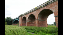
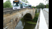
Highlights on the route for me were looking at some of York's industrial heritage, the open farmland above Gate Helmsley, and the lovely old stone road bridge and brick railway viaduct at Stamford Bridge.
-
Share your thoughts
Ruth
07 May 2021This is a good route to walk. It follows Route 66 cycle way to Murton.
Slight problem leaving Murton as public footpath not obvious and hate didn’t open. Slight detour to farm track put you back on the public footpath. Easy to follow on the footpaths but 4 stiles to negotiate. The last stile being very high and a tricky climb.
Easy road walk along very quiet tarmac road to Warthill where there is a pub, garden centre and village pond with seating for a break.
Public footpath to Gate Hemlmsley very easy to follow but followed by a noisy walk along main road for 10 minutes to pick up the cycle way into Stamford Bridge. Also have to cross this busy Road. However, there is another garden centre with cafe if you need a break.
Cycle way into Stamford Bridge easy to follow and you can drop down to walk in along the river bank.
It took me 3 hours including a 20 minutes lunch break.
I would walk it again and happy to recommend the route.
-
Share your thoughts
Share your views about this route, give it a star rating, indicate whether it should be verified or not.
Include information that will be useful to others considering to walk or wheel it.
You can add up to 15 photos.
Other Routes for York—Stamford Bridge See all Slow Ways
Review this better route and help establish a trusted network of walking routes.
Suggest a better route if it better meets our methodology.
Share your thoughts