Description
This is a Slow Ways route connecting Ynysddu and Risca.
Know of a better route? Share it here.
This is a Slow Ways route connecting Ynysddu and Risca.
Know of a better route? Share it here.
Status
This route has been reviewed by 1 person.
There are no issues flagged.
Photos for Ynyris two

Photos of this route will appear when they are added to a review. You can review this route here.
Information

Route status - Live
Reviews - 1
Average rating -
Is this route good enough? - Yes (1)
There are currently no problems reported with this route.
Downloads - 3
Surveys
We are working to build-up a picture of what routes look like. To do that we are asking volunteers to survey routes so that we can communicate features, obstacles and challenges that may make a route desirable or not.
Slow Ways surveyors are asked to complete some basic online training, but they are not vetted. If you are dependent on the survey information being correct in order to complete a route, we recommend that you think critically about the information provided. You may also wish to wait until more than one survey has been completed.
Help people know more about this route by volunteering to submit a survey.
- Complete the survey training.
- Submit a survey for this route.
Geography information system (GIS) data
Total length
Maximum elevation
Minimum elevation
Start and end points
Ynysddu
Grid Ref
ST1793692772
Lat / Lon
51.62776° / -3.18697°
Easting / Northing
317,936E / 192,772N
What3Words
reception.verve.sized
Risca
Grid Ref
ST2446890212
Lat / Lon
51.60566° / -3.09207°
Easting / Northing
324,468E / 190,212N
What3Words
takers.forest.crinkled
Ynyris Two's land is
| Ynysddu | |
|---|---|
| Grid Ref | ST1793692772 |
| Lat / Lon | 51.62776° / -3.18697° |
| Easting / Northing | 317,936E / 192,772N |
| What3Words | reception.verve.sized |
| Risca | |
|---|---|
| Grid Ref | ST2446890212 |
| Lat / Lon | 51.60566° / -3.09207° |
| Easting / Northing | 324,468E / 190,212N |
| What3Words | takers.forest.crinkled |
| Other agricultural land | 9.8% |
| Pasture | 7.7% |
| Urban | 16.3% |
| Woods | 66.1% |
Data: Corine Land Cover (CLC) 2018
review
Paul Chilcott
06 May 2022Direction: Risca to Ynysddu, early May 2022
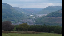
After a short walk through Risca from the station, the path goes under the A467 by-pass to Dan-y-Graig and through a small nature reserve (Photos 1 & 2). However, the path out of the reserve was blocked, so I went back down on to the lane, turned right and followed Tir-y-Cwm Lane right to the end, then turned right at the junction with the lane coming up from Ochrwyth. The idea was to join the Raven Walk footpath as close as possible to the planned route, but this was also blocked, so I continued on up the footpath to the forestry track around half way up Mynnydd Machen and followed it westwards, where there are some great views down into and across the valleys (Photo 3). On reaching a junction with another lane, and turning right to go downhill, I finally joined the Raven Walk, just above Glenside. The path here is a broad forestry track along the hillside until going down the hillside to join the cycle path (National Route 47) route through the Sirhowy Valley Country Park (Photo 4) at the Nine Mile Point picnic site. There is no signage at all after leaving the nature reserve at Risca until reaching the cycle path. The detour added an extra 2 km to the walk.
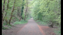
The walk through the Sirhowy Valley Country Park is a real delight, with plenty of short detours to explore along the way. This takes you all the way into Ynysddu. An excellent walk through varied terrain.
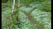
Photos 1 and 2 - Dan-y-Graig Nature Reserve
Photo 3 - View up the Ebbw Valley from the lane on Mynnydd Machen
Photo 4 - Path through the Sirhowy Valley Country Park.
Share your views about this route, give it a star rating, indicate whether it should be verified or not.
Include information that will be useful to others considering to walk or wheel it.
You can add up to 15 photos.
Other Routes for Ynysddu—Risca See all Slow Ways
Review this better route and help establish a trusted network of walking routes.
Suggest a better route if it better meets our methodology.
Share your thoughts