Description
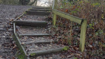
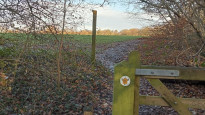
This is a longer route than 1 and 2, but with less road. It takes advantage of the Arboretum, the canal and Cuckoo's Nook (part of the Beacon Way) to avoid the roads, but for the last few kilometres some road is unavoidable. There are several short flights of steps mainly through Cuckoo's Nook, so would be unsuitable for wheelchairs or pushchairs. I did the walk in December 2022, and it was quite muddy, especially on the shortest path through the Arboretum. There is a better path further south through the Arboretum, joining the canal further south, which would make the route slightly longer
This is a longer route than 1 and 2, but with less road. It takes advantage of the Arboretum, the canal and Cuckoo's Nook (part of the Beacon Way) to avoid the roads, but for the last few kilometres some road is unavoidable. There are several short flights of steps mainly through Cuckoo's Nook, so would be unsuitable for wheelchairs or pushchairs. I did the walk in December 2022, and it was quite muddy, especially on the shortest path through the Arboretum. There is a better path further south through the Arboretum, joining the canal further south, which would make the route slightly longer
Status
This route has been reviewed by 1 person.
There are no issues flagged.
Photos for Walsstr three


Photos of this route will appear when they are added to a review. You can review this route here.
Information

Route status - Live
Reviews - 1
Average rating -
Is this route good enough? - Yes (1)
There are currently no problems reported with this route.
Downloads - 4
Surveys
We are working to build-up a picture of what routes look like. To do that we are asking volunteers to survey routes so that we can communicate features, obstacles and challenges that may make a route desirable or not.
Slow Ways surveyors are asked to complete some basic online training, but they are not vetted. If you are dependent on the survey information being correct in order to complete a route, we recommend that you think critically about the information provided. You may also wish to wait until more than one survey has been completed.
Help people know more about this route by volunteering to submit a survey.
- Complete the survey training.
- Submit a survey for this route.
Geography information system (GIS) data
Total length
Maximum elevation
Minimum elevation
Start and end points
Walsall
Grid Ref
SP0119698577
Lat / Lon
52.58501° / -1.98378°
Easting / Northing
401,196E / 298,577N
What3Words
riders.decide.parent
Streetly
Grid Ref
SP0791797772
Lat / Lon
52.57772° / -1.88460°
Easting / Northing
407,917E / 297,772N
What3Words
whips.adding.above
| Walsall | |
|---|---|
| Grid Ref | SP0119698577 |
| Lat / Lon | 52.58501° / -1.98378° |
| Easting / Northing | 401,196E / 298,577N |
| What3Words | riders.decide.parent |
| Streetly | |
|---|---|
| Grid Ref | SP0791797772 |
| Lat / Lon | 52.57772° / -1.88460° |
| Easting / Northing | 407,917E / 297,772N |
| What3Words | whips.adding.above |
Sorry Land Cover data is not currently available for this route. Please check back later.
review
Nigel Cull
15 Mar 2024This is a longer route than Walsstr one & two, but has less pavement walking.
Starting from Walsall you go through the enjoyable Arboretum which was very muddy at my time of walking so i had to take the path to the South joining the canal path before reaching the Beacon Way at Rushall locks.
This takes through the very nice Hayhead Wood with benches to have a rest and birdwatch before going on field paths and then pavement walking passing the Foley Arms for refreshment ending in Streetly.
There are several short flights of steps so would be unsuitable for wheelchairs or pushchairs.
Overall a good slowways route.
Share your views about this route, give it a star rating, indicate whether it should be verified or not.
Include information that will be useful to others considering to walk or wheel it.
You can add up to 15 photos.
Other Routes for Walsall—Streetly See all Slow Ways
Review this better route and help establish a trusted network of walking routes.
Suggest a better route if it better meets our methodology.
Share your thoughts