Description
This is a Slow Ways route connecting Uttoxeter and Ashbourne.
Know of a better route? Share it here.
This is a Slow Ways route connecting Uttoxeter and Ashbourne.
Know of a better route? Share it here.
Status
This route has been reviewed by 6 people.
This route has been flagged (1 times) for reasons relating to accuracy.
Photos for Uttash one


Photos of this route will appear when they are added to a review. You can review this route here.
Information
")
Route status - Live
Reviews - 6
Average rating -
Is this route good enough? - Yes (5) Maybe (1)
Problems reported - Accuracy (1)
Downloads - 12
Surveys
What is this route like?
Surveys are submitted by fellow users of this website and show what you might expect from this Slow Ways route. Scroll down the page to read more detailed surveys.
| Grade 5X based on 1 surveys | Sign up or log in to survey this route. | ||
|---|---|---|---|
| Description | Note | ||
| Grade 5: Route includes technical and arduous terrain where there may be potentially impassable barriers if the correct equipment is not used or barriers which require assistance to overcome. Potential barriers must be photographed and described. Access grade X: At least one stile, flight of steps or other obstacle that is highly likely to block access for wheelchair and scooter users. |
Grading is based on average scores by surveyors. This slow way has 1 surveys. | ||
| Full grading description | |||
Only people who have completed our training can become Slow Ways surveyors and submit a survey. We do not vet contributors, so we cannot guarantee the quality or completeness of the surveys they complete. If you are dependent on the information being correct we recommend reading and comparing surveys before setting off.
Survey Photos

Facilities
Facilities in the middle third of this route.
Challenges
Potential challenges reported on this route. Some challenges are seasonal.
Obstacles
Obstacles on this route.
Accessibility
Is this route step and stile free?
Measurements
Surveyors were asked to measure the narrowest and steepest parts of paths.
Narrowest part of path: no data
The steepest uphill gradient East: no data
The steepest uphill gradient West: no data
The steepest camber: no data
We don't have clear data on the waymarking (1)
Successfully completed
We asked route surveyors "Have you successfully completed this route with any of the following? If so, would you recommend it to someone with the same requirements?". Here is how they replied.
Recommended by an expert
We asked route surveyors "Are you a trained access professional, officer or expert? If so, is this route suitable for someone travelling with any of the following?" Here is how they replied.
Terrain
We asked route surveyors to estimate how much of the route goes through different kinds of terrain.
There is no data on how much of this route is on roads
There is no data on how much of this route is lit at night
Thereis no data on amount of route paved
There is no data on muddiness
There is no data on rough ground
There is no data on long grass
Report a problem with this data
1 surveys
Information from verified surveys.
Geography information system (GIS) data
Total length
Maximum elevation
Minimum elevation
Start and end points
Uttoxeter
Grid Ref
SK0921333646
Lat / Lon
52.90020° / -1.86448°
Easting / Northing
409,213E / 333,646N
What3Words
remarked.flamenco.cubic
Ashbourne
Grid Ref
SK1806646458
Lat / Lon
53.01514° / -1.73216°
Easting / Northing
418,066E / 346,458N
What3Words
reefs.compacts.single
Uttash One's land is
| Uttoxeter | |
|---|---|
| Grid Ref | SK0921333646 |
| Lat / Lon | 52.90020° / -1.86448° |
| Easting / Northing | 409,213E / 333,646N |
| What3Words | remarked.flamenco.cubic |
| Ashbourne | |
|---|---|
| Grid Ref | SK1806646458 |
| Lat / Lon | 53.01514° / -1.73216° |
| Easting / Northing | 418,066E / 346,458N |
| What3Words | reefs.compacts.single |
| Arable | 8.1% |
| Pasture | 79.9% |
| Urban | 10.5% |
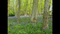
| Woods | 1.6% |
Data: Corine Land Cover (CLC) 2018
reviews
Eddie Jones
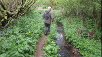
12 Feb 2023Walked from Ashbourne to Uttoxeter in winter. First half was easy going with rolling dales, scenic views and plenty of wildlife. Interesting to see the Shrovetide goal at Clifton. A comfortable bench at Roston for lunch. From here walk became much more difficult. Extremely steep bank out of Roston, followed by indistinct paths across fields with deep ditches and broken bridges. Take care here. At Rocester the path improves as the Staffordshire Way is followed to the finish.
J w ollid
12 Feb 2023Enjoyable route however difficult bits:poor way marking,a very steep bank east of Royston(the hollow)plus some deep ditches which don’t have safe bridges.
-
Share your thoughts
Ken
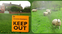
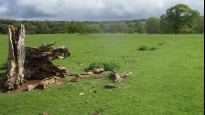
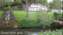
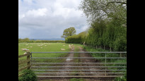
05 May 2022This is a good walk, it's direct and well plotted, towards the north end it has some excellent views. The Staffordshire Way has evidence of other users but further north you will have the paths to yourself. There are cattle, stiles and difficult stiles, overgrown stiles, ploughed fields and little if any cross field reinstatement through crops, although most fields are pasture. This is twelve miles and there are no services around half way. Sections by the River Dove are prone to flooding and the Ashbourne end is best avoided on Shrove Tuesday as the route passes the Down'Ards goal. Keep a careful eye on the map and you will enjoy this adventure.
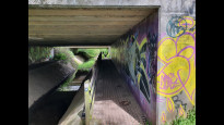
I walked Uttoxeter to Ashbourne on a day of showers after a long dry spell. The roads leaving Uttoxeter need care crossing but away from these the footpath was once built up over the water meadow with ancient stone flood arches. Cross the Dove alongside the noisy A50 then dive down and pass underneath, a detour to the old bridge is worthwhile. A walked path was evident across the rough field which assists navigation, then a gentle climb. Ignore the signed left turn and stay on the high ground along the field edge.
I was assured that walkers are welcome to use the cafe / bar at the shooting club but it's a bit close to the route end. This is JCB territory and they make sure you know it but we don't pass the factory only the sporting estate. Later the path crosses the games field of Abbotsholme school where a tap by the path might quench your thirst on a hot day.
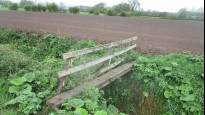
Rocester is about half way. The route doesn't pass through the village so consider a detour or bail out as there is nothing now to Ashbourne. The next section starts with no signage from the road and a locked gate which sets the tone nicely. The cross field path was invisible but I pressed on keeping a close eye on the plotted route which got me through. A nasty crossing of a deep ditch was the next obstacle so another report went in for this.
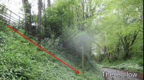
I did consider diverting off the route to pass through Roston where the Inn has a camp site and is open from noon at weekends but this was Wednesday and the door would remain closed until 6pm. I was pleased to see on the Derbyshire online map that new finger posts are on order at Highfield House. Passing to the south east of Roston finding the path was a game of hide and seek which ended with a slide down a steep slope to the road. Another report asking for steps to make the path safe to use, the road here is called The Hollow. There is a seat on the green by the red kiosk which once offered a phone but now provides books.
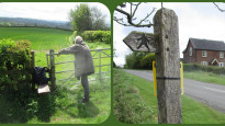
Another gentle climb from the village to a gate and stile with a view. At the boundary into Snelston parish another fence which was once a stile but the step stool appears to have given up the ghost many seasons ago and is now almost lost in the ground where it lays. North of Snelson Firs paths cross in the centre of a cropped field again the way is not apparent so care is needed. Fortunately the path is signed from Virginsally, that name should tell a good story. The path stays on higher ground offering a pleasant view into the stream side settlement.
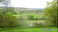
The church at Snelston makes a good waymark but again only a bench in the churchyard offers a resting place for weary walkers. Perhaps best to make use of that seat because while the path through the park is a delight, it is also a climb, take a breather and turn around. Over the top and another great vista into the Dove valley and a view of the three Mayfields. Back by the river it's easy walking but cattle are present and the locals walk by the river while the path crosses the meadow.
At the road it would be a short detour to visit The Cock Inn at Clifton but so close to the end I press on passing the Down'Ards goal on the Henmore Brook, the path is now well used before joining the road for the final stretch into Ashbourne. A great walk but perhaps not a good Slow Way.
-

John Johnson
05 May 2022Very Interesting!
-
Share your thoughts
Walker99
22 Apr 2022From Uttoxeter to Rocester the route is mostly well signposted especially after it joins the Staffordshire Way at Dove Bridge. There is a shooting club on the route and red flags indicate when firing is taking place. A peacock lives on the farm nearby and seems to be untroubled by it.
From Rocester towards Roston the path is very badly waymarked and difficult to follow. I got lost and had to give up. There is an hourly daytime bus service if needed from Rocester to Ashbourne and Uttoxeter.
-
Share your thoughts
Simonalcock
17 May 2021The first 10km follows the Staffordshire Way long dustance patha nd is well marked and easy to follow. From 10 to 13km the paths are somewhat indistinct over open farm land - suggest taking a printed map and using teh field boundaries, from 13km to teh finish the views are fantastic although some fairly steep hils to be negotiated. The whole route has numerous high stiles and gates.
-
Share your thoughts
Malcolm Boura
02 May 2021I have walked the route between Ashbourne and Snelston in the last few months. All of that is suitable for inclusion.
There is a newly constructed (well, completed in the last few years) path along the Henmore Brook between Ashbourne town centre and the A52. See Open Street Map.
-
Malcolm Boura
02 Jan 20242 Jan 2024. The bridge over the Henmore Brook near the A52 roundabout footballers statue has been washed away. Either walk along Mayfield Rd into Ashbourne or turn east along the A52 until opposite Aldi where there is another way onto the path. I expect that the bridge will be repaired before long.
-
Share your thoughts
Share your views about this route, give it a star rating, indicate whether it should be verified or not.
Include information that will be useful to others considering to walk or wheel it.
You can add up to 15 photos.
There are no other routes for Uttoxeter — Ashbourne
If you know a better way, then please let us know.
Review this better route and help establish a trusted network of walking routes.
Suggest a better route if it better meets our methodology.
Share your thoughts