Southborough — Tonbridge
Souton one

Slow Way not verified yet. Verify Souton here.
Slow Way not verified yet. Verify Souton here.
By a Slow Ways Volunteer on 07 Apr 2021
Description
This is a Slow Ways route connecting Southborough and Tonbridge.
Know of a better route? Share it here.
This is a Slow Ways route connecting Southborough and Tonbridge.
Know of a better route? Share it here.
Status
This route has been reviewed by 1 person.
There are no issues flagged.
Photos for Souton one


Photos of this route will appear when they are added to a review. You can review this route here.
Information
Route status - Live
Reviews - 1
Average rating -
Is this route good enough? - Yes (1)
There are currently no problems reported with this route.
Downloads - 11
Surveys
What is this route like?
Surveys are submitted by fellow users of this website and show what you might expect from this Slow Ways route. Scroll down the page to read more detailed surveys.
| Grade 3X based on 1 surveys | Sign up or log in to survey this route. | ||
|---|---|---|---|
| Description | Note | ||
| Grade 3: Route includes rough surfaces that may include small boulders, potholes, shallow ruts, loose gravel, short muddy sections. Access grade X: At least one stile, flight of steps or other obstacle that is highly likely to block access for wheelchair and scooter users. |
Grading is based on average scores by surveyors. This slow way has 1 surveys. | ||
| Full grading description | |||
Only people who have completed our training can become Slow Ways surveyors and submit a survey. We do not vet contributors, so we cannot guarantee the quality or completeness of the surveys they complete. If you are dependent on the information being correct we recommend reading and comparing surveys before setting off.
Survey Photos
Facilities
Facilities in the middle third of this route.
Challenges
Potential challenges reported on this route. Some challenges are seasonal.
Obstacles
Obstacles on this route.
Accessibility
Is this route step and stile free?
Measurements
Surveyors were asked to measure the narrowest and steepest parts of paths.
The narrowest part of the path is 12.0cm (1)
The steepest uphill gradient walking East 25.0% (1)
The steepest uphill gradient walking West 16.0% (1)
The steepest camber: no data
How clear is the waymarking on the route: Unclear in places (1)
Successfully completed
We asked route surveyors "Have you successfully completed this route with any of the following? If so, would you recommend it to someone with the same requirements?". Here is how they replied.
Recommended by an expert
We asked route surveyors "Are you a trained access professional, officer or expert? If so, is this route suitable for someone travelling with any of the following?" Here is how they replied.
Terrain
We asked route surveyors to estimate how much of the route goes through different kinds of terrain.
54.0% of the route is on roads (1)
40.0% of the route is lit at night (1)
40.0% of the route is paved (1)
10.0% of the route is muddy (1)
10.0% of the route is over rough ground (1)
5.0% of the route is through long grass (1)
Report a problem with this data
1 surveys
Information from verified surveys.
Geography information system (GIS) data
Total length
Maximum elevation
Minimum elevation
Start and end points
Southborough
Grid Ref
TQ5812742111
Lat / Lon
51.15641° / 0.25981°
Easting / Northing
558,127E / 142,111N
What3Words
vocal.bucked.moved
Tonbridge
Grid Ref
TQ5905346521
Lat / Lon
51.19577° / 0.27499°
Easting / Northing
559,053E / 146,521N
What3Words
organ.hungry.mock
Souton One's land is
| Southborough | |
|---|---|
| Grid Ref | TQ5812742111 |
| Lat / Lon | 51.15641° / 0.25981° |
| Easting / Northing | 558,127E / 142,111N |
| What3Words | vocal.bucked.moved |
| Tonbridge | |
|---|---|
| Grid Ref | TQ5905346521 |
| Lat / Lon | 51.19577° / 0.27499° |
| Easting / Northing | 559,053E / 146,521N |
| What3Words | organ.hungry.mock |
| Arable | 11.5% |
| Pasture | 34.4% |
| Urban | 48.3% |
| Woods | 5.8% |
Data: Corine Land Cover (CLC) 2018
review
Daisy C
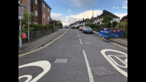
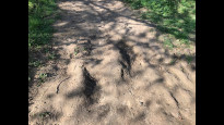
04 Jul 2023Nice walk, pretty direct but the road walking near Mount Farm is unpavemented, high hedged and has quite tight turns. Probably a better bet in wet weather than SouTon 2, there were only a few pretty short bits that must have been very muddy in spring.
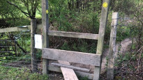
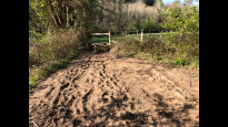
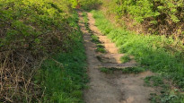
Started at Southborough. Left the village then into some meadows with small woodlands, probably a local nature reserve or similar, very . Where you leave the lower meadows the path and postmarker were rather hidden where tree boughs had drooped down. The path continuing around the meadows is far more well used so could be distracting. From here on is farm land, mostly grazing. There was a cow with a calf so small, wobbly and damp that it may have only been born today. Next is the road section without a pavement and very poor sight lines. I was very alert to approaching cars but didn't actually feel unsafe as they passed. Only saw four, one felt the need to beep approaching each corner.
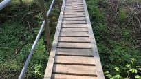
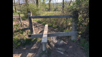
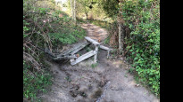
There's a little bridge over a stream which is cambered different ways at either end, but disconcerting. There's a few stiles along the way with missing or no steps.
Walking in through Tonbridge seems like it could be on quieter roads. It was simple to navigate and did have a great view though.
Share your views about this route, give it a star rating, indicate whether it should be verified or not.
Include information that will be useful to others considering to walk or wheel it.
You can add up to 15 photos.
Other Routes for Southborough—Tonbridge See all Slow Ways
Review this better route and help establish a trusted network of walking routes.
Suggest a better route if it better meets our methodology.
Share your thoughts