Description
I devised this route as an alternative to the fully main road route Rothoo One
I devised this route as an alternative to the fully main road route Rothoo One
Status
This route has been reviewed by 3 people.
There are no issues flagged.
Photos for Rothoo two


Photos of this route will appear when they are added to a review. You can review this route here.
Information
")
Route status - Live
Reviews - 3
Average rating -
Is this route good enough? - Yes (3)
There are currently no problems reported with this route.
Downloads - 1
Surveys
What is this route like?
Surveys are submitted by fellow users of this website and show what you might expect from this Slow Ways route. Scroll down the page to read more detailed surveys.
| Grade 4X based on 1 surveys | Sign up or log in to survey this route. | ||
|---|---|---|---|
| Description | Note | ||
| Grade 4: Route includes very rough surfaces including deep ruts, steep loose gravel, unmade paths and deep muddy sections. Wheelchairs may experience traction/wheel spin issues. Access grade X: At least one stile, flight of steps or other obstacle that is highly likely to block access for wheelchair and scooter users. |
Grading is based on average scores by surveyors. This slow way has 1 surveys. | ||
| Full grading description | |||
Only people who have completed our training can become Slow Ways surveyors and submit a survey. We do not vet contributors, so we cannot guarantee the quality or completeness of the surveys they complete. If you are dependent on the information being correct we recommend reading and comparing surveys before setting off.
Survey Photos
Facilities
Facilities in the middle third of this route.
Challenges
Potential challenges reported on this route. Some challenges are seasonal.
Obstacles
Obstacles on this route.
Accessibility
Is this route step and stile free?
Measurements
Surveyors were asked to measure the narrowest and steepest parts of paths.
The narrowest part of the path is 50.0cm (1)
The steepest uphill gradient walking East 36.0% (1)
The steepest uphill gradient walking West 14.0% (1)
The steepest camber: no data
How clear is the waymarking on the route: Unclear in places (1)
Successfully completed
We asked route surveyors "Have you successfully completed this route with any of the following? If so, would you recommend it to someone with the same requirements?". Here is how they replied.
Recommended by an expert
We asked route surveyors "Are you a trained access professional, officer or expert? If so, is this route suitable for someone travelling with any of the following?" Here is how they replied.
Terrain
We asked route surveyors to estimate how much of the route goes through different kinds of terrain.
There is no data on how much of this route is on roads
There is no data on how much of this route is lit at night
Thereis no data on amount of route paved
There is no data on muddiness
There is no data on rough ground
There is no data on long grass
Report a problem with this data
1 surveys
Information from verified surveys.
Geography information system (GIS) data
Total length
Maximum elevation
Minimum elevation
Start and end points
Rotherham
Grid Ref
SK4279893053
Lat / Lon
53.43255° / -1.35730°
Easting / Northing
442,798E / 393,053N
What3Words
admits.unable.deputy
Hooton Roberts
Grid Ref
SK4843197081
Lat / Lon
53.46827° / -1.27190°
Easting / Northing
448,431E / 397,081N
What3Words
bared.stickler.slimmer
| Rotherham | |
|---|---|
| Grid Ref | SK4279893053 |
| Lat / Lon | 53.43255° / -1.35730° |
| Easting / Northing | 442,798E / 393,053N |
| What3Words | admits.unable.deputy |
| Hooton Roberts | |
|---|---|
| Grid Ref | SK4843197081 |
| Lat / Lon | 53.46827° / -1.27190° |
| Easting / Northing | 448,431E / 397,081N |
| What3Words | bared.stickler.slimmer |
Sorry Land Cover data is not currently available for this route. Please check back later.
reviews
Hugh Hudson
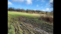
06 Mar 2024 (edited 07 Mar 2024)Walked from Hooton Roberts to Doncaster. A good route, though Mousehole Lane is unsurfaced, muddy and steep in places. I think it has dried a little since January as the deep mud was all easily avoidable.
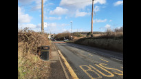
From Hooton Roberts it is best to stay on the north side of Sheffield Road, which has a continuous pavement. Take care at the junction with Kilnhurst Road and when crossing to the entrance of the Thrybergh Reservoir country park. There is a cafe and toilets here (not the middle third of the route yet though). The walk round the reservoir is well surfaced popular and scenic, and I agree that it is the best thing on this route. We leave the crowds to go straight on on another surfaced path into Thrybergh, where the street route has a shop - there is also a slightly shorter footpath option here. We have to cross Hollings Road, which may need a little care, and the start of Mousehole Lane is not signposted, and is on the edge of a car park.
The lane is unsurfaced and quite muddy, and evidently very popular with motorbikes (fortunately I didn't meet any). The initial section is quite steep and might be tricky in wet or icy conditions. The burnt out car was still there, but though there was plenty of mud it was all well below the top of my boots. Another short pavement walk is followed by a surfaced track that starts by a playground. Beyond the stream crossing the surfaced? path is under a large puddle, so most walkers seem to ignore it at this point. We then go quite steeply uphill to Dalton Lane. From here we are mostly on pavements with good safe crossings of the major roads.
Highlights of this section were the spacious Broadway (East) and the crossing of Clifton Park. We also pass a couple more shops. Beyond the park we continue on pavements into the centre of Rotherham then head right through the pedestrianised streets by the Minster to reach the meeting point by the bus station. For the most part this is a pleasant and enjoyable walk.
Susan
25 Feb 2024From Sheffield you can get to the start of this route by train, bus or tram. I was pleasantly surprised by Rotherham, as both the town centre, with its magnificent, elevated minster, and the suburbs we walked through were very nice, especially Clifton Park. There are loos here if you arrive at the right time of year, when the children’s play area is open.
There is a longish walk through residential areas before you get to open country, after which wellies are good if there’s been a lot of rain. There is quite a steep bit during this section where the track is rutted and muddy, and although we didn’t see anyone, it looked as though some less than wholesome car-related activities had been carried out here. There’s a dodgy road crossing at the top of this slope, after which there’s a short walk through some residential roads, including a well-hidden footpath between the backs of houses.
After a short walk between fields, you come to Thrybergh Reservoir, which is a great location for bird spotters! This was my favourite part of the walk, in spite of the fact that we didn’t stop at the cafe. On leaving the park however, you have to cross a fast road and then walk up the narrow pavement along this road for about a mile. Your reward is to arrive at The Earl of Strafford in the hamlet of Hooton Roberts, where a very nice pub lunch can be had!.
-
Share your thoughts
Mary Oz
29 Jan 2024We headed through the shopping centre of Rotherham and past the Minster, before walking through the pleasant Clifton Park. A string of off-road suburban paths, wide residential streets, and a surfaced path at Dalton eventually led us to a muddy path alongside a stream at Thrybergh, with quite a rural feel.
There was a steep and muddy climb up to the road from here, with an abandoned burnt-out car! However, the view back from the top was good.
We passed beneath a disused railway, and were soon heading towards Thrybergh Reservoir. This was the highlight of the walk, with a good path all round it, plentiful wildfowl, and a café at the end.
This was followed by the lowlight of the walk – nearly a mile of walking along the narrow pavement of a busy road, where conversation was very difficult due to traffic noise and having to walk single file. I’m so glad we didn’t walk Rothoo One, which I guess is just lots more of this. I prefer walking a bit further to avoid huge amounts of road traffic.
I’m torn between 3* and 4* for this route, but I’m going for 4* because it had a nice mixture of environments and I can’t spot any practical alternative to the road at the end.
-
Share your thoughts
Share your views about this route, give it a star rating, indicate whether it should be verified or not.
Include information that will be useful to others considering to walk or wheel it.
You can add up to 15 photos.
Other Routes for Rotherham—Hooton Roberts See all Slow Ways
Review this better route and help establish a trusted network of walking routes.
Suggest a better route if it better meets our methodology.
Share your thoughts