Pontllan-fraith — Risca
Ponris two

Slow Way not verified yet. Verify Ponris here.
Slow Way not verified yet. Verify Ponris here.
By Paul Chilcott on 28 Jan 2024
Description
This route is an alternative to Ponris1, due to the access issues at Danygraig, Risca and also after crossing the A467 and entering the forest just north of Cross Keys.https://www.plotaroute.com/route/2501880?units=km
This route is an alternative to Ponris1, due to the access issues at Danygraig, Risca and also after crossing the A467 and entering the forest just north of Cross Keys.https://www.plotaroute.com/route/2501880?units=km
Status
This route has been reviewed by 1 person.
There are no issues flagged.
Photos for Ponris two


Photos of this route will appear when they are added to a review. You can review this route here.
Information
Route status - Live
Reviews - 1
Average rating -
Is this route good enough? - Yes (1)
There are currently no problems reported with this route.
Downloads - 0
Surveys
We are working to build-up a picture of what routes look like. To do that we are asking volunteers to survey routes so that we can communicate features, obstacles and challenges that may make a route desirable or not.
Slow Ways surveyors are asked to complete some basic online training, but they are not vetted. If you are dependent on the survey information being correct in order to complete a route, we recommend that you think critically about the information provided. You may also wish to wait until more than one survey has been completed.
Help people know more about this route by volunteering to submit a survey.
- Complete the survey training.
- Submit a survey for this route.
Geography information system (GIS) data
Total length
Maximum elevation
Minimum elevation
Start and end points
Pontllan-fraith
Grid Ref
ST1818095963
Lat / Lon
51.65648° / -3.18419°
Easting / Northing
318,180E / 195,963N
What3Words
hidden.lurching.knots
Risca
Grid Ref
ST2446890212
Lat / Lon
51.60566° / -3.09207°
Easting / Northing
324,468E / 190,212N
What3Words
takers.forest.crinkled
| Pontllan-fraith | |
|---|---|
| Grid Ref | ST1818095963 |
| Lat / Lon | 51.65648° / -3.18419° |
| Easting / Northing | 318,180E / 195,963N |
| What3Words | hidden.lurching.knots |
| Risca | |
|---|---|
| Grid Ref | ST2446890212 |
| Lat / Lon | 51.60566° / -3.09207° |
| Easting / Northing | 324,468E / 190,212N |
| What3Words | takers.forest.crinkled |
Sorry Land Cover data is not currently available for this route. Please check back later.
review
Paul Chilcott
28 Jan 2024January 2024. Direction: Risca to Pontllanfraith.
This route is an alternative to Ponris1 due to the access issues at Danygraig, Risca and also the forest area just north of the A467 at Cross Keys.
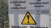
An excellent walk and the route is clear provided there are no forestry operations, which may close the forest tracks. Technically, it was closed on the day of my walk, according to the signs, but I asked one of the machine operators if it was OK to go through and he said yes. He also said that there are a lot of operations and path closures at the moment, which are expected to continue until June 2024, so it may be better to skip this one until after then.
It`s a mixed walk. Initially through the streets of Risca, then through the woods, an industrial estate and then the forestry section just north of the A467 at Cross Keys. The route then leads on to the Raven Way, which takes you up Mynyddislwyn. After leaving the Raven Way, the path leads down through the fields into Pontllanfraith. There are some excellent views from up on the mountain. It`s also a quite peaceful walk once away from the main roads The forestry section is not well signed until the route meets the Raven Way. From there it is well signed and the styles and gates are in good order until the fields section going down into Pontllanfraith, where I had to jump one tied gate.
Photo 1 - The path leading on from Danygraig Road, Risca
Photo 2 - Forestry path closed just north of Cross Keys (temporary)
Photo 3 - View from the Raven Way
Photo 4 - The Raven Way path going up Mynyddislwyn
Photo 5 - View from the top of Mynyddislwyn towards Abercarn.
Share your views about this route, give it a star rating, indicate whether it should be verified or not.
Include information that will be useful to others considering to walk or wheel it.
You can add up to 15 photos.
Other Routes for Pontllan-fraith—Risca See all Slow Ways
Review this better route and help establish a trusted network of walking routes.
Suggest a better route if it better meets our methodology.
Share your thoughts