Description
This is a Slow Ways route connecting North Woolwich and Woolwich.
Know of a better route? Share it here.
This is a Slow Ways route connecting North Woolwich and Woolwich.
Know of a better route? Share it here.
Status
This route has been reviewed by 7 people.
There are no issues flagged.
Photos for Norwoo one


Photos of this route will appear when they are added to a review. You can review this route here.
Information
")
Route status - Live
Reviews - 7
Average rating -
Is this route good enough? - Yes (7)
There are currently no problems reported with this route.
Downloads - 4
Surveys
What is this route like?
Surveys are submitted by fellow users of this website and show what you might expect from this Slow Ways route. Scroll down the page to read more detailed surveys.
| Grade 1X based on 1 surveys | Sign up or log in to survey this route. | ||
|---|---|---|---|
| Description | Note | ||
| Grade 1: Entirely smooth and compacted surfaces. Access grade X: At least one stile, flight of steps or other obstacle that is highly likely to block access for wheelchair and scooter users. |
Grading is based on average scores by surveyors. This slow way has 1 surveys. | ||
| Full grading description | |||
Only people who have completed our training can become Slow Ways surveyors and submit a survey. We do not vet contributors, so we cannot guarantee the quality or completeness of the surveys they complete. If you are dependent on the information being correct we recommend reading and comparing surveys before setting off.
Survey Photos
Facilities
Facilities in the middle third of this route.
Challenges
Potential challenges reported on this route. Some challenges are seasonal.
Obstacles
Obstacles on this route.
Accessibility
Is this route step and stile free?
Measurements
Surveyors were asked to measure the narrowest and steepest parts of paths.
The narrowest part of the path is 100.0cm (1)
The steepest uphill gradient walking East 4.0% (1)
The steepest uphill gradient walking West 4.0% (1)
The steepest camber: no data
How clear is the waymarking on the route: Unsigned (1)
Successfully completed
We asked route surveyors "Have you successfully completed this route with any of the following? If so, would you recommend it to someone with the same requirements?". Here is how they replied.
Recommended by an expert
We asked route surveyors "Are you a trained access professional, officer or expert? If so, is this route suitable for someone travelling with any of the following?" Here is how they replied.
Terrain
We asked route surveyors to estimate how much of the route goes through different kinds of terrain.
50.0% of the route is on roads (1)
100.0% of the route is lit at night (1)
100.0% of the route is paved (1)
There is no data on muddiness
There is no data on rough ground
There is no data on long grass
Report a problem with this data
1 surveys
Information from verified surveys.
Geography information system (GIS) data
Total length
Maximum elevation
Minimum elevation
Start and end points
North Woolwich
Grid Ref
TQ4319879774
Lat / Lon
51.49877° / 0.06161°
Easting / Northing
543,198E / 179,774N
What3Words
laptop.solid.sizes
Woolwich
Grid Ref
TQ4372878823
Lat / Lon
51.49009° / 0.06885°
Easting / Northing
543,728E / 178,823N
What3Words
legend.tester.drives
Norwoo One's land is
| North Woolwich | |
|---|---|
| Grid Ref | TQ4319879774 |
| Lat / Lon | 51.49877° / 0.06161° |
| Easting / Northing | 543,198E / 179,774N |
| What3Words | laptop.solid.sizes |
| Woolwich | |
|---|---|
| Grid Ref | TQ4372878823 |
| Lat / Lon | 51.49009° / 0.06885° |
| Easting / Northing | 543,728E / 178,823N |
| What3Words | legend.tester.drives |
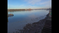
| Estuary | 33.0% |
| Urban | 67.0% |
Data: Corine Land Cover (CLC) 2018
reviews
Strider
03 Dec 2023I walked South to North.
Agree with previous reviewers.
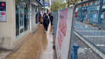
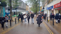
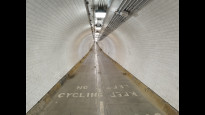
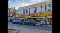
Lovely High Street with shops followed by a sub marine tunnel, super.
The North side lifts were closed for maintainance on this day, lots of stairs! but otherwise good for wheels when working. Check here:
https://www.royalgreenwich.gov.uk/info/200259/transport_and_travel/693/foot_tunnels
Nice jaunt.
David Sanderson
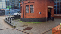
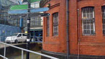
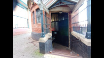
23 Jan 2023A Slow Way with an X Factor, as walking through the Woolwich Tunnel is a fun thing to do. I started this walk from North Woolwich, so finding the entrance was not an issue. At the southern end the route takes you round a somewhat preposterous loop, and for that indirectness it loses a star. The Woolwich end presents you with numerous stops and shops as well as public transport links. An enjoyable walk!.
-
Share your thoughts
Daisy C
17 Jan 2023 (edited 13 Mar 2023)Good route. Walking under the Thames through the Woolwich Tunnel is fun. I'm giving 5 stars despite the slightly weird route line near the South tunnel entrance
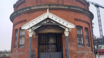
The other reviews are right, the round tunnel entrance building is well hidden, and then the stairs door is further hidden. It's a shame, the sister tunnel at Greenwich is a treasured landmark.
There were empty beer cans and the smell of urine part way down the south stairs. You can easily use the Woolwich Ferry instead, also fun, great at sunset, but has a wind chill factor. You can check online for closures of both.
-
Daisy C
03 Mar 2023The Waterfront leisure centre which surrounds the tunnel entrance building is going to be replaced then redeveloped within a few years. Hopefully that will be an improvement for tunnel users.
-
Share your thoughts
Dannyash
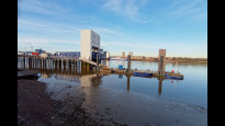
02 Sep 2022This route follows the very last bit of the Capital Ring through the Woolwich Foot tunnel and is therefore well signposted, although as has been said before not the easiest to find from the South Side. A pretty unique experience being able to walk under the Thames (only a few places you can do it) and was very quiet when I did it.
-
Share your thoughts
ShortLegsLongWalk
14 Jul 2022A simple route made interesting by its use of the Woolwich foot tunnel, which I would otherwise have been unaware of.
-
Share your thoughts
Charles Hedley
24 Mar 2022Good alternative to getting the DLR if you want a walk. Previous review is accurate.
-
Share your thoughts
Jenny_mills
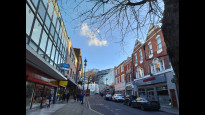
25 Apr 2021If you're travelling north-to-south, the first third or so of the route is through the Woolwich Foot Tunnel, which is well-let and safe any time of day or night (see photo). Once you've emerged on the other side, you don't actually need to kink along to the roundabout, you can go straight up the side of the leisure centre. The road crossing is well-marked, and the rest of the route is on a slight but easy incline; and it's pedestrianised once you're on Powis Street. If you're travelling south-to-north the entrance to the tunnel can be a little tricky to find, as it's tucked away being the leisure centre. The only reason I'm giving it 4 rather than 5 stars is that sometimes one or other of the lifts down to the tunnel is down for maintenance, and the alternative stairwells are over 100 steps long and in a spiral, so are significantly less accessible. If you need an accessible route over the river and one of the lifts is down, your alternatives are to use the ferry (which is basically in the same spot on the river) or to get the DLR between Woolwich Arsenal and King George V.
-
Share your thoughts
Share your views about this route, give it a star rating, indicate whether it should be verified or not.
Include information that will be useful to others considering to walk or wheel it.
You can add up to 15 photos.
There are no other routes for North Woolwich — Woolwich
If you know a better way, then please let us know.
Review this better route and help establish a trusted network of walking routes.
Suggest a better route if it better meets our methodology.
Share your thoughts