New Ollerton — Newark-on-Trent
Newonew two

Verified Slow Way
Verified by 100.00% of reviewers
Verified Slow Way
Verified by 100.00% of reviewers
By Ken on 23 Apr 2023
Description
Newonew has a couple of minor but important issues that need amendment, see below.
Newonew-2 is much the same, but safer, at the Newark end, I also offer an alternative towards Ollerton which provides an all day cafe at Eakring and a delightful small pub at Maplebeck.
I can't review Newonew because I didn't walk it but having explored issues from Newonew-2 I feel that the path across the A46 at Newark is unsafe and there is no link to the tree covered former spoil heap hill at Ollerton. The path at Beesthorpe Hall has had a minor diversion but this is clear on the ground
Status
This route has been reviewed by 3 people.
There are no issues flagged.
Photos for Newonew two


Photos of this route will appear when they are added to a review. You can review this route here.
Information
Route status - Live
Reviews - 3
Average rating -
Is this route good enough? - Yes (3)
There are currently no problems reported with this route.
Downloads - 1
Surveys
What is this route like?
Surveys are submitted by fellow users of this website and show what you might expect from this Slow Ways route. Scroll down the page to read more detailed surveys.
| Grade 5X based on 1 surveys | Sign up or log in to survey this route. | ||
|---|---|---|---|
| Description | Note | ||
| Grade 5: Route includes technical and arduous terrain where there may be potentially impassable barriers if the correct equipment is not used or barriers which require assistance to overcome. Potential barriers must be photographed and described. Access grade X: At least one stile, flight of steps or other obstacle that is highly likely to block access for wheelchair and scooter users. |
Grading is based on average scores by surveyors. This slow way has 1 surveys. | ||
| Full grading description | |||
Only people who have completed our training can become Slow Ways surveyors and submit a survey. We do not vet contributors, so we cannot guarantee the quality or completeness of the surveys they complete. If you are dependent on the information being correct we recommend reading and comparing surveys before setting off.
Survey Photos
Facilities
Facilities in the middle third of this route.
Challenges
Potential challenges reported on this route. Some challenges are seasonal.
Obstacles
Obstacles on this route.
Accessibility
Is this route step and stile free?
Measurements
Surveyors were asked to measure the narrowest and steepest parts of paths.
Narrowest part of path: no data
The steepest uphill gradient East: no data
The steepest uphill gradient West: no data
The steepest camber: no data
We don't have clear data on the waymarking (1)
Successfully completed
We asked route surveyors "Have you successfully completed this route with any of the following? If so, would you recommend it to someone with the same requirements?". Here is how they replied.
Recommended by an expert
We asked route surveyors "Are you a trained access professional, officer or expert? If so, is this route suitable for someone travelling with any of the following?" Here is how they replied.
Terrain
We asked route surveyors to estimate how much of the route goes through different kinds of terrain.
There is no data on how much of this route is on roads
There is no data on how much of this route is lit at night
Thereis no data on amount of route paved
There is no data on muddiness
There is no data on rough ground
There is no data on long grass
Report a problem with this data
1 surveys
Information from verified surveys.
Geography information system (GIS) data
Total length
Maximum elevation
Minimum elevation
Start and end points
New Ollerton
Grid Ref
SK6632867909
Lat / Lon
53.20414° / -1.00844°
Easting / Northing
466,328E / 367,909N
What3Words
shortcuts.argued.siblings
Newark-on-Trent
Grid Ref
SK7995353844
Lat / Lon
53.07588° / -0.80799°
Easting / Northing
479,954E / 353,845N
What3Words
locker.pegs.refrained
| New Ollerton | |
|---|---|
| Grid Ref | SK6632867909 |
| Lat / Lon | 53.20414° / -1.00844° |
| Easting / Northing | 466,328E / 367,909N |
| What3Words | shortcuts.argued.siblings |
| Newark-on-Trent | |
|---|---|
| Grid Ref | SK7995353844 |
| Lat / Lon | 53.07588° / -0.80799° |
| Easting / Northing | 479,954E / 353,845N |
| What3Words | locker.pegs.refrained |
Sorry Land Cover data is not currently available for this route. Please check back later.
reviews
Hugh Hudson
13 May 2023 (edited 14 May 2023)Walked from Newark to Ollerton. A long route, enjoyable in places, but spoiled a little by some challenging poorly maintained field paths. There are stiles, steps, long grass and other minor obstacles, but there are also several villages with pubs and some fine views.
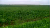
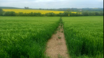
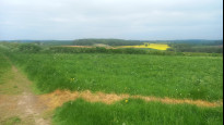
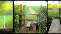
The route from Newark to Kelham Bridge is almost the same as SOUNEW 1, which I walked in December. The path from the rugby club to Kelham Bridge is still in a poor state - there was one oliseed rape field where the cut path is far too narrow (picture 2) and the final field is easiest to cross using waterlogged tractor trails. Beyond Kelham the path is much better, and the walk through Averham Park is interesting, though sadly I didn't see any racehorses, let alone galloping ones. Beyond Muskham Woodhouse Farm the path is little used and poorly maintained. The bridge over the stream takes some spotting through the undergrowth, and there is no sign of a path in the huge field beyond, and the crops are 3 to 4 feet high in places so this section is hard work (picture 6).
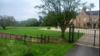
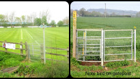
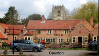
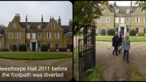
Eventually we reach the road to Caunton (cross the A616 with care). Caunton has two pubs en route, but I had no time to linger with almost 10 miles still to walk. The field path west is little used but easy enough to follow, and beyond the A616 Beesthorpe Hall dominates the view ahead. The path follows a ha-ha round the garden and heads through the wood to emerge on a farm track. Further ahead it seems that most walkers stay left of the hedge rather than using the right of way line in the field to the right, and one of the field boundaries in the large pasture has gone, which enables a shortcutting diagonal.
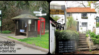
We cross a lane and use another diagonal field path to reach Maplebeck, where the tiny Beehive pub offers a welcome break (picture 10). The path onwards to Eakring has a few ups and downs but is well maintained and easy to follow. Near the village there is another place where most locals stay left of a hedge and the right of way is right of it. There are steps both sides of a dumble on the edge of Eakring, Here we join NEWSOU 3, another route I walked recently. I might have been tempted to vary the route through the village, as there are no facilities or pavements on Church Lane and there is a quieter path alternative. We return to the main road by the old pub, which still shows no signs of life, though the tea room beyond still seems to be functioning.
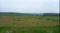
We head up out of the village and take the track right that leads us back on to the Robin Hood way. This section has fine views, and the fields are in a much better state than last time I was here in March. The Robin Hood way path takes a rather indirect route to reach North Laiths, where we leave it on another well maintained path that takes us into a railway cutting (more steps) and up to Wellow. We follow the roads round to the old colliery site, then take a longer but easier route than NEWSOU 3 around the old spoil heap (this is fine, though a shorter easy route is available as used in NEWOSUT 1). I did like the variation at the end which allows the meeting point in New Ollerton to be reached from the east side, though this did allow me to see the bus I had just missed.
StephenWalker
11 May 2023I walked this route starting at Ollerton. I agree that this route is preferable to that taken by Newonew1. I found the route to be an enjoyable country walk, well described by Ken in his report from April 2023. The exit from Ollerton is on pavements and quiet paths through the 'eco-village'. Having tried both, the path around the 'west tip' plotted by Ken is preferable to trying to climb it. Entering Wellow there is a public footpath (not on the map) straight ahead alongside the brook which gets you off the main road, cuts the corner, but avoids the pub.
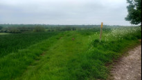
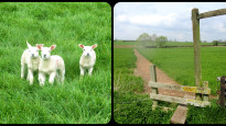
The path from Wellow to Eakring is easily followed. There is a steep flight of steps into and out of the former railway cutting. From Eakring to Maplebeck the path was muddy but easily followed. Maplebeck to Caunton is also easily followed but (coming from Ollerton) the diversion at Beesthorpe Hall is not well signed and I ended up (temporarily) in the farmyard. From Caunton we start alongside the roads. Aftercrossing the A616 the section southwards from the road bend & signpost heading over the fields is across cropland. At first, tractor tracks in the crop approximate to the correct line, but after the first ditchboards I needed to take a compass bearing and eventually found the second ditchboard easily enough. Thereafter the line is easily followed and it was a straight forward countryside walk to Kelham, with good views across the Trent valley.
From Kelham Bridge the line of the path had at least been marked to start with (muddy, waterfilled tractor track) however approaching the rugby club ground there is a problem where somebody has dumped building waste across the line, and the kissing gate is now in the middle of a blackthorn thicket. The yellow marked posts are a guide to direction. Across the rugby pitches (easier with no games on !) and then into Newark on pavements. A good route overall.
-
Share your thoughts
Ken
23 Apr 2023A good mix of paths, cross field, headland and tracks plus some quiet lanes and a short noisey pavement walk at Kelham. There are two inns at Caunton and a cafe at Eakring which breaks the trip into three sections. Also a delightful small Inn at Maplebeck. There are stiles but lots of gates and some steps. Cattle are a possibility and horses.
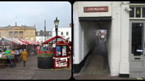
I walked from Newark taking Chain Lane from the Marketplace to cross the town bridge by the castle remains and then passing Castle station. The road walk here is shared with a cycle track and the A46 crossing is light controlled but the Old Great North Road has only a refuge and traffic off the island can be an issue.
The narrow pavement alongside the next road offers little comfort from passing traffic. It should be a welcome escape onto the footpath but the Rugby club makes little if any acknowledgement of the path and beyond that it's overgrown but doable to Kelham bridge. An inn here but there's still a long way to go.
Off the main road things improve significantly and from here I enjoyed this walk very much. Our path climbs to offer good views and after crossing a road the route enters an equestrian centre for race horses where we cross the practice course four times.
At the exit we cross a road which offered an alternative route if required. The path from here heads north and is less well maintained. The path crosses a stream by a hidden bridge then crosses a large field, the plot will guide you to the next bridge to cross another field to the road. This takes us to Caunton with a main road crossing at the junction. The route passes the two inns but I sat in the churchyard for an early lunch.
Leaving the village the route is across pasture and there were cattle here before another crossing of the main road. More pasture this time grazed by sheep and some new lambs as we approach Beesthorpe Hall. A close and interesting encounter with the impressive hall where the path now follows the ha-ha then onto a farm track.
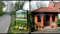
So far the route has followed Newonew but we soon turn to the road and head for Maplebeck. I felt fortunate to find the Beehive Inn open so had a pint and a break. Here I picked up a leaflet about the on demand bus service that now serves this area, so if you need to bail out you will need to download an app.
I was apprehensive about the next stretch across large fields but was delighted to find the paths clear and well maintained all the way to Eakring where we meet the Robin Hood Way. Daffodil Tea Room may attract you to take a break before the final section of the route.
More cross field and a high point with good views of the route ahead then farm tracks which lead into Wellow. More inns but we are now close to the finish with a section of pavement walking to a footpath around Ollerton Tip Wood, Newsou-3 uses a steep path over the hump but this route stays low level if a little longer.
The paths through the commercial area are inviting and this routes takes in more of the New Ollerton shops approaching from the opposite direction. Despite one or two niggles this was a most enjoyable walk.
-

Ken
25 Apr 2023As stated in the review there were a few niggles which I reported to Nottinghamshire CC via their website. I received a very promt reply "Thanks for the report below which has been passed to the Rights of Way Team. I’ve logged the issues and will add the path to our inspection list. As these are cultivation and cropping issues they will be passed straight to our enforcement officer."
-
Share your thoughts
Share your views about this route, give it a star rating, indicate whether it should be verified or not.
Include information that will be useful to others considering to walk or wheel it.
You can add up to 15 photos.
Other Routes for New Ollerton—Newark-on-Trent See all Slow Ways
Review this better route and help establish a trusted network of walking routes.
Suggest a better route if it better meets our methodology.
Share your thoughts