Description
Current proposal is safe and direct albeit part not available due to building works. Route well drawn. But:
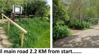
ST 91967 63332 to ST 92289 63047 not available. Path closed with builders fencing. Alternative route not obvious.
A better and quicker route to Redstocks ST 93175 62683 is via Clackers Brook which means much less road walking and through 'urban nature reserve'.
Better route through Melksham suggested see GPX (630_Meldev_Melksham_DevizesAdjustedDaveY20210503.gpx) which also avoids messy farmyard ST 93075 62717 to ST 93151 62685 where gate might be shut!
Current proposal is safe and direct albeit part not available due to building works. Route well drawn. But:
ST 91967 63332 to ST 92289 63047 not available. Path closed with builders fencing. Alternative route not obvious.
A better and quicker route to Redstocks ST 93175 62683 is via Clackers Brook which means much less road walking and through 'urban nature reserve'.
Better route through Melksham suggested see GPX (630_Meldev_Melksham_DevizesAdjustedDaveY20210503.gpx) which also avoids messy farmyard ST 93075 62717 to ST 93151 62685 where gate might be shut!
Status
This route has been reviewed by 2 people.
There are no issues flagged.
Photos for Meldev two


Photos of this route will appear when they are added to a review. You can review this route here.
Information

Route status - Live
Reviews - 2
Average rating -
Is this route good enough? - Yes (2)
There are currently no problems reported with this route.
Downloads - 7
Surveys
What is this route like?
Surveys are submitted by fellow users of this website and show what you might expect from this Slow Ways route. Scroll down the page to read more detailed surveys.
| Grade 3X based on 1 surveys | Sign up or log in to survey this route. | ||
|---|---|---|---|
| Description | Note | ||
| Grade 3: Route includes rough surfaces that may include small boulders, potholes, shallow ruts, loose gravel, short muddy sections. Access grade X: At least one stile, flight of steps or other obstacle that is highly likely to block access for wheelchair and scooter users. |
Grading is based on average scores by surveyors. This slow way has 1 surveys. | ||
| Full grading description | |||
Only people who have completed our training can become Slow Ways surveyors and submit a survey. We do not vet contributors, so we cannot guarantee the quality or completeness of the surveys they complete. If you are dependent on the information being correct we recommend reading and comparing surveys before setting off.
Survey Photos

Facilities
Facilities in the middle third of this route.
Challenges
Potential challenges reported on this route. Some challenges are seasonal.
Obstacles
Obstacles on this route.
Accessibility
Is this route step and stile free?
Measurements
Surveyors were asked to measure the narrowest and steepest parts of paths.
The narrowest part of the path is 70.0cm (1)
The steepest uphill gradient walking East 30.0% (1)
The steepest uphill gradient walking West 30.0% (1)
The steepest camber gradient across the path 5.0% (1)
How clear is the waymarking on the route: Clear (1)
Successfully completed
We asked route surveyors "Have you successfully completed this route with any of the following? If so, would you recommend it to someone with the same requirements?". Here is how they replied.
Recommended by an expert
We asked route surveyors "Are you a trained access professional, officer or expert? If so, is this route suitable for someone travelling with any of the following?" Here is how they replied.
Terrain
We asked route surveyors to estimate how much of the route goes through different kinds of terrain.
2.0% of the route is on roads (1)
15.0% of the route is lit at night (1)
57.0% of the route is paved (1)
5.0% of the route is muddy (1)
2.0% of the route is over rough ground (1)
3.0% of the route is through long grass (1)
Report a problem with this data
1 surveys
Information from verified surveys.
Geography information system (GIS) data
Total length
Maximum elevation
Minimum elevation
Start and end points
Melksham
Grid Ref
ST9045663638
Lat / Lon
51.37172° / -2.13849°
Easting / Northing
390,456E / 163,638N
What3Words
amplified.diverged.digestion
Devizes
Grid Ref
SU0040261483
Lat / Lon
51.35242° / -1.99561°
Easting / Northing
400,402E / 161,483N
What3Words
barbarian.stop.likely
| Melksham | |
|---|---|
| Grid Ref | ST9045663638 |
| Lat / Lon | 51.37172° / -2.13849° |
| Easting / Northing | 390,456E / 163,638N |
| What3Words | amplified.diverged.digestion |
| Devizes | |
|---|---|
| Grid Ref | SU0040261483 |
| Lat / Lon | 51.35242° / -1.99561° |
| Easting / Northing | 400,402E / 161,483N |
| What3Words | barbarian.stop.likely |
Sorry Land Cover data is not currently available for this route. Please check back later.
reviews
DaveYearsley
20 Jun 2021Most routes leaving Melksham are dull, but the Town has created a pleasant green corridor along Clackers Brook which this route follows as far as Redstocks.
An ordnance survey map and ideally the means to follow a GPS is required. Albeit once you have reached the Canal it is a no brainer.
A flat route of approximately 5% street , 40% canal and the rest is fields which can be muddy and slippery. Some fields are scruffy and some are meadow like. There are a few stiles and awkward gates. Some fields can be avoided after Rusty Lane Farm and taking the straight route (South South East) to the Canal - this is shown in Photo 11.
Entering Devizes Town (1%) involves short walk via a busy road but there are buildings of historical interest.
Brian
06 May 2021As comments on Meldev one, I have slightly amended the Meldev two route to take out field public footpaths with stiles, and replaced with additional canal towpath.
-
DaveYearsley
20 Jun 2021Meldev One involves too much road and parts of route are closed. Meldev Four is the only Wheelchair route, has longest proportion of route on Canal and the easiest to follow albeit there are a lot of busy dull and noisy roads. Meldev Three avoids some fields (after Rusty Lane Farm) in Meldev One and Two - with this in mind see Photo 11 in Reviw by DaveYearsley — 20 Jun 2021.
-
Share your thoughts
Share your views about this route, give it a star rating, indicate whether it should be verified or not.
Include information that will be useful to others considering to walk or wheel it.
You can add up to 15 photos.
Other Routes for Melksham—Devizes See all Slow Ways
Review this better route and help establish a trusted network of walking routes.
Suggest a better route if it better meets our methodology.
DaveYearsley
29 Jun 2021To view an image in full, right click and 'open into a new tab'
Share your thoughts