Description
This is a Slow Ways route connecting Market Weighton and Beverley.
Know of a better route? Share it here.
This is a Slow Ways route connecting Market Weighton and Beverley.
Know of a better route? Share it here.
Status
This route has been reviewed by 4 people.
This route has been flagged (1 times) for reasons relating to accuracy.
Photos for Marbev one


Photos of this route will appear when they are added to a review. You can review this route here.
Information
")
Route status - Live
Reviews - 4
Average rating -
Is this route good enough? - Yes (3) Maybe (1)
Problems reported - Accuracy (1)
Downloads - 8
Surveys
We are working to build-up a picture of what routes look like. To do that we are asking volunteers to survey routes so that we can communicate features, obstacles and challenges that may make a route desirable or not.
Slow Ways surveyors are asked to complete some basic online training, but they are not vetted. If you are dependent on the survey information being correct in order to complete a route, we recommend that you think critically about the information provided. You may also wish to wait until more than one survey has been completed.
Help people know more about this route by volunteering to submit a survey.
- Complete the survey training.
- Submit a survey for this route.
Geography information system (GIS) data
Total length
Maximum elevation
Minimum elevation
Start and end points
Market Weighton
Grid Ref
SE8764941789
Lat / Lon
53.86495° / -0.66866°
Easting / Northing
487,649E / 441,789N
What3Words
defensive.tent.preheated
Beverley
Grid Ref
TA0380139550
Lat / Lon
53.84185° / -0.42390°
Easting / Northing
503,801E / 439,550N
What3Words
shoulders.pull.travel
Marbev One's land is
| Market Weighton | |
|---|---|
| Grid Ref | SE8764941789 |
| Lat / Lon | 53.86495° / -0.66866° |
| Easting / Northing | 487,649E / 441,789N |
| What3Words | defensive.tent.preheated |
| Beverley | |
|---|---|
| Grid Ref | TA0380139550 |
| Lat / Lon | 53.84185° / -0.42390° |
| Easting / Northing | 503,801E / 439,550N |
| What3Words | shoulders.pull.travel |
| Arable | 57.2% |
| Pasture | 26.5% |
| Urban | 16.3% |
Data: Corine Land Cover (CLC) 2018
reviews
Zara Connor
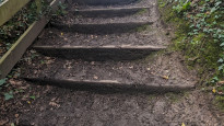
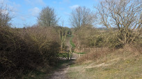
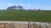
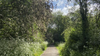
23 Mar 2024A flat and easy walk suitable for almost all ages and fitness levels, predominantly on the Beverley-Market Weighton Rail Trail. Mostly grass/gravel path with some stairs for road crossings (pictures showing these). As it's the old railway line it's mostly tree-lined without views across the Wolds, but pleasant enough for a day out.
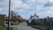
Route does unnecessarily divert through Etton but this is a pretty village with a pub for a lunch stop if needed. Minor error in gps file to rejoin the rail trail after Etton - you need to turn right and loop under the bridge to rejoin, unlike route GPS (see screenshot).
At either end of the trail there were lots of dog walkers/off-lead dogs.
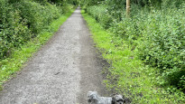
Path is prone to get boggy over winter/rainy periods - I wore trail running shoes which were good for this route as some grip is needed but not full walking boots unless you prefer these.
Jonathon Wells
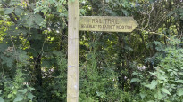
05 Nov 2023If it has been wet then some sections of the railway near Cherry Burton do get boggy, but generally this is an excellent easy walking route. Only one road to cross. Only a few steps, otherwise flat or very gradual inclines as it is an old railway route. Interesting history and wonderfully quiet.
-
Share your thoughts
Julian Willis
10 Jul 2022Great walk along the Hudson Way. Surface good throughout and flat so easy walking. Intermittent shade which is good on a sunny day. Crosses a few quiet roads but is otherwise all off road. Only loses a star because the route diverts to Etton which is not necessary - you can just carry on along the Hudson Way.
-
Share your thoughts
Share your views about this route, give it a star rating, indicate whether it should be verified or not.
Include information that will be useful to others considering to walk or wheel it.
You can add up to 15 photos.
There are no other routes for Market Weighton — Beverley
If you know a better way, then please let us know.
Review this better route and help establish a trusted network of walking routes.
Suggest a better route if it better meets our methodology.
Share your thoughts