Description
This is a Slow Ways route connecting Lower Stondon and Hitchin.
Know of a better route? Share it here.
This is a Slow Ways route connecting Lower Stondon and Hitchin.
Know of a better route? Share it here.
Status
This route has been reviewed by 4 people.
This route has been flagged (1 times) for reasons relating to accuracy.
Photos for Lowhit one


Photos of this route will appear when they are added to a review. You can review this route here.
Information
")
Route status - Live
Reviews - 4
Average rating -
Is this route good enough? - Yes (3) Maybe (1)
Problems reported - Accuracy (1)
Downloads - 5
Surveys
We are working to build-up a picture of what routes look like. To do that we are asking volunteers to survey routes so that we can communicate features, obstacles and challenges that may make a route desirable or not.
Slow Ways surveyors are asked to complete some basic online training, but they are not vetted. If you are dependent on the survey information being correct in order to complete a route, we recommend that you think critically about the information provided. You may also wish to wait until more than one survey has been completed.
Help people know more about this route by volunteering to submit a survey.
- Complete the survey training.
- Submit a survey for this route.
Geography information system (GIS) data
Total length
Maximum elevation
Minimum elevation
Start and end points
Lower Stondon
Grid Ref
TL1539434931
Lat / Lon
52.00085° / -0.32045°
Easting / Northing
515,394E / 234,931N
What3Words
banquets.orbit.audible
Hitchin
Grid Ref
TL1943129718
Lat / Lon
51.95314° / -0.26349°
Easting / Northing
519,431E / 229,718N
What3Words
cheeks.sank.keen
Lowhit One's land is
| Lower Stondon | |
|---|---|
| Grid Ref | TL1539434931 |
| Lat / Lon | 52.00085° / -0.32045° |
| Easting / Northing | 515,394E / 234,931N |
| What3Words | banquets.orbit.audible |
| Hitchin | |
|---|---|
| Grid Ref | TL1943129718 |
| Lat / Lon | 51.95314° / -0.26349° |
| Easting / Northing | 519,431E / 229,718N |
| What3Words | cheeks.sank.keen |
| Arable | 52.7% |
| Pasture | 14.1% |
| Urban | 33.2% |
Data: Corine Land Cover (CLC) 2018
reviews
Strider
05 Mar 2023I walked from Hitchin to Lower Stondon.
This route cannot be walked due to mapping errors. The paths on the OS map have changed, tree planting, diversions, new fences and new houses have altered this route. This is shown by the previous reviewer's multiple alternative suggestions. I have uploaded an alternative walkable route, but it is also not good as I don't know this area, I hope a local person can upload a definitive walkable path.
However, you can walk close to this route, you don't stray far from it, if you pay attention to the map.
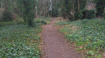
All that aside - This is a lovely enjoyable walk through open fields, mostly off road.
Generally flat but rough, narrow, muddy patches make it unsuitable for wheels.
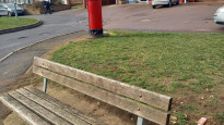
Lower Stondon is small but the Local Store has a large selection of beers, English, Scottish, Belgium, Dutch, real, craft and tins. There's bench to rest, eat sandwiches, and drink your chosen beverage.
Greysquirrel
24 Apr 2022I live in Ickleford so broke the walk into two sections, walking to lower stondon an alternative route and then following the slow way back to Ickleford. Then I did the section from Ickleford to Hitchin the next day.
I really enjoyed the walk from lower stondon, there are good paths through fields pretty easy to follow. It was a sunny day and I agree the paths would be trickier in winter when likely to be very muddy.
Living in Ickleford I often walk to Hitchin station and the route here is what I would call "the scenic route" as it follows the river through some lovely off road parks. There are a couple of paths to choose, one nearer the river and one following the embankment beside the railway line. The river one is narrower and less suitable for wheels. Both paths get very muddy in winter.
I would not choose to walk to station that way if in a hurry and not in winter, the way following roads and pavements along Bury Mead Road or Strathmore road to meet the route at Grove Road, would be easier and faster, better for pushchairs etc. But not as pretty! On a lovely summer day the river path is a really nice option.
-
Share your thoughts
Graham
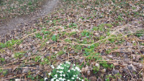
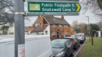
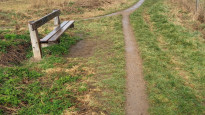
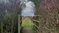
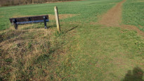
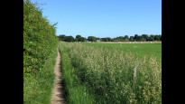
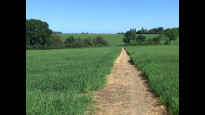
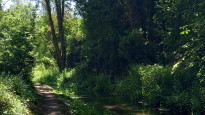
29 Jun 2021I walked this route in both directions on the 14th June and really enjoyed it. As with the previous review for this route I would recommend walking through Ransoms Rec. You can just turn right at the end of the Rec onto Grove Road to go under the bridge on the pavement or alternatively there is a small track along the river to the right of the basketball court. This short track leads to the Triangle Community Garden where another path on the far side of the garden leads under the bridge on the opposite side of the river to the pavement. The path under the bridge here is very uneven and whilst only very short might not be to everyone's liking. I then joined the river on a track following the Hicca Way just past the children's nursery school on Grove Road and before the pedestrian crossing. This track takes you by the river all the way to Ickleford. Whilst I enjoy this section it does get very muddy when it rains, the track is narrow in places, at times it can be overgrown with nettles (these had been cut back when I walked it) and you have to go under a low bridge walking on pieces of wood that have been laid across a very short muddy/wet area. However if you are able to walk this section then it is lovely following the river and seeing the occasional kingfisher and lots of ducks (and ducklings). After Ickleford the walk is cross country with lovely views and lots of red kites overhead. As has already been stated there seems to be little in Lower Stondon so I turned round and walked back to enjoy it all again! I attach 2 photos of the paths and one of a small bridge between Ickleford and Lower Stondon and one of the track by the river between Grove Road and Ickleford.
-
Share your thoughts
Al M
25 Apr 2021I found this to be an enjoyable route, mostly on footpaths and bridleways and through a couple of villages.
There are a few gentle gradients and some good views over the surrounding countryside.
The route within Hitchin and just north of the town avoids too much pavement walking, instead going through a park, along a short riverside path and through a nature reserve.
A few points:
- I’d suggest a slight short cut through Ransom’s Rec in Hitchin and along a path south of the river (just take care when crossing the road between the Rec and the Purwell River path - the pedestrian crossing is further along the road).
- Between Ickleford and where the footpath goes under the railway bridge, the path on the ground is a little to the east of the path marked on maps, running alongside an old embankment.
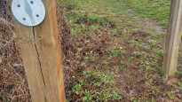
- North of Holwell the route uses a cross-field footpath likely to be very muddy in winter.
- Lower Stondon does not seem to have much in the way of amenities on the route except a convenience store. There are many food & drink options on or near the route in Hitchin and a shop and pubs in Ickleford just north of Hitchin.
-
Share your thoughts
Share your views about this route, give it a star rating, indicate whether it should be verified or not.
Include information that will be useful to others considering to walk or wheel it.
You can add up to 15 photos.
Other Routes for Lower Stondon—Hitchin See all Slow Ways
Review this better route and help establish a trusted network of walking routes.
Suggest a better route if it better meets our methodology.
Share your thoughts