Lostwithiel — Liskeard
Loslis one

Slow Way not verified yet. Verify Loslis here.
Slow Way not verified yet. Verify Loslis here.
By a Slow Ways Volunteer on 07 Apr 2021
Description
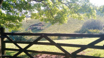
This is a Slow Ways route connecting Lostwithiel and Liskeard.
Know of a better route? Share it here.
This is a Slow Ways route connecting Lostwithiel and Liskeard.
Know of a better route? Share it here.
Status
This route has been reviewed by 1 person.
This route has been flagged (1 times) for reasons relating to access.
Photos for Loslis one


Photos of this route will appear when they are added to a review. You can review this route here.
Information
Route status - Live
Reviews - 1
Average rating -
Is this route good enough? - Maybe (1)
Problems reported - Access (1)
Downloads - 7
Surveys
We are working to build-up a picture of what routes look like. To do that we are asking volunteers to survey routes so that we can communicate features, obstacles and challenges that may make a route desirable or not.
Slow Ways surveyors are asked to complete some basic online training, but they are not vetted. If you are dependent on the survey information being correct in order to complete a route, we recommend that you think critically about the information provided. You may also wish to wait until more than one survey has been completed.
Help people know more about this route by volunteering to submit a survey.
- Complete the survey training.
- Submit a survey for this route.
Geography information system (GIS) data
Total length
Maximum elevation
Minimum elevation
Start and end points
Lostwithiel
Grid Ref
SX1066459795
Lat / Lon
50.40743° / -4.66596°
Easting / Northing
210,664E / 59,795N
What3Words
locked.befitting.patrolled
Liskeard
Grid Ref
SX2510164613
Lat / Lon
50.45520° / -4.46524°
Easting / Northing
225,101E / 64,613N
What3Words
exotic.haunts.posed
Loslis One's land is
| Lostwithiel | |
|---|---|
| Grid Ref | SX1066459795 |
| Lat / Lon | 50.40743° / -4.66596° |
| Easting / Northing | 210,664E / 59,795N |
| What3Words | locked.befitting.patrolled |
| Liskeard | |
|---|---|
| Grid Ref | SX2510164613 |
| Lat / Lon | 50.45520° / -4.46524° |
| Easting / Northing | 225,101E / 64,613N |
| What3Words | exotic.haunts.posed |
| Arable | 31.9% |
| Other | 0.8% |
| Pasture | 31.9% |
| Urban | 7.1% |
| Woods | 28.3% |
Data: Corine Land Cover (CLC) 2018
review
Edensyard
25 Sep 2022 (edited 26 Sep 2022)I had a great day walking this route but it has a few issues as a slowway.
Exiting Lostwithiel was hilly (the whole route is) but fun via Dutchy land.
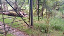
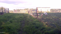
On crossing the A390 no entry was stated on the gate to Bodmin Lodge, I thought maybe this referred more to the cottage and pressed on. The route as given took me to a resolutely locked fence in a wild wood. A workaround Boconnoc House took me through a very smart private estate and deer park. A kind gentleman who filled my water bootle just outside the estate explained that locals do often pass through and as long as they simply walk or run and dont go near the house no one seems to mind. This was my experience too but I think this is technically a tresspass.
I declined the detour to EastTaphouse because I considered the B3359 too dangerous.
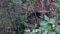
The footpath on the other side of the road had a broken sign and was overgrown, the path through Connon Bridge Cottage was lost to brambles but had a smart newish stile underneath them. On leaving the house I closed the gate and looked back to see many signs with discouraging messages on the pemisess and gate itself in spite of the clear public footpath waymarker opposite. It would be a committed walker to enter from that direction and challenge the signs and brambles (uphill) though it is a designated path. Shame: it is a small but important section.
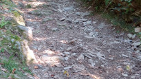
Bodrawl wood was beautiful if steep.
The rest of the way was varied and enjoyable. a number of places are large farmsteads rather than villages so opportunities for rest are limited for a route of this length. I asked for water at a few houses in the absence of pubs and was kindly received.
I think with good conduct passing through the deer park the main issues are the busy road on the detour and one unhappy neighbour.
I would hope this route could be adjusted to work - it has much to reccommend it.
Share your views about this route, give it a star rating, indicate whether it should be verified or not.
Include information that will be useful to others considering to walk or wheel it.
You can add up to 15 photos.
There are no other routes for Lostwithiel — Liskeard
If you know a better way, then please let us know.
Review this better route and help establish a trusted network of walking routes.
Suggest a better route if it better meets our methodology.
Share your thoughts