Description
Leolud two is more accurately plotted that the original Leolud. Leolud two sticks to PROWs, unlike the original Leolud which makes several forays onto private land with no right of way across it
Leolud two is more accurately plotted that the original Leolud. Leolud two sticks to PROWs, unlike the original Leolud which makes several forays onto private land with no right of way across it
Status
This route has been reviewed by 4 people.
There are no issues flagged.
Photos for Leolud two


Photos of this route will appear when they are added to a review. You can review this route here.
Information
")
Route status - Live
Reviews - 4
Average rating -
Is this route good enough? - Yes (4)
There are currently no problems reported with this route.
Downloads - 1
Surveys
We are working to build-up a picture of what routes look like. To do that we are asking volunteers to survey routes so that we can communicate features, obstacles and challenges that may make a route desirable or not.
Slow Ways surveyors are asked to complete some basic online training, but they are not vetted. If you are dependent on the survey information being correct in order to complete a route, we recommend that you think critically about the information provided. You may also wish to wait until more than one survey has been completed.
Help people know more about this route by volunteering to submit a survey.
- Complete the survey training.
- Submit a survey for this route.
Geography information system (GIS) data
Total length
Maximum elevation
Minimum elevation
Start and end points
Leominster
Grid Ref
SO4969059026
Lat / Lon
52.22714° / -2.73798°
Easting / Northing
349,690E / 259,026N
What3Words
relishing.sports.truth
Ludlow
Grid Ref
SO5098374600
Lat / Lon
52.36726° / -2.72132°
Easting / Northing
350,983E / 274,600N
What3Words
struts.lamps.whirlpool
| Leominster | |
|---|---|
| Grid Ref | SO4969059026 |
| Lat / Lon | 52.22714° / -2.73798° |
| Easting / Northing | 349,690E / 259,026N |
| What3Words | relishing.sports.truth |
| Ludlow | |
|---|---|
| Grid Ref | SO5098374600 |
| Lat / Lon | 52.36726° / -2.72132° |
| Easting / Northing | 350,983E / 274,600N |
| What3Words | struts.lamps.whirlpool |
Sorry Land Cover data is not currently available for this route. Please check back later.
reviews
J Walker
31 Mar 2024Great day’s walk, lots of interest and - mostly - well marked paths. Pub at Orleton is perfectly placed mid route. Takes you high at times for some good views.
C Hanson
31 Mar 2024Enjoyed this route out of Ludlow. I thought I knew the town well but this path was new to me, over the river at Ludford, weaving up and out of the town through some lovely old buildings, past a cemetery, eventually connecting with the main Overton road. Along here the footpath veers off over the hills to Overton, Clee Hill dominates the skyline to your left. So far so good. Things got a little trickier around Moor Park, the path isn’t always clearly marked, some badly maintained styles and you’ll be walking through a place which has a bit of an edge to it - and emus. From here the walk is wonderful, woods and open land with great views and the paths were easy to navigate. No pub at Richard’s Castle which disappointed one of our group greatly, but there’s The Boot Inn at Orleton, which cheered him up no end. The village also has a useful shop. After crossing the railway line, the route passes through Eye; approaching the church and old manor house over the fields, talk turned to 1970's British horror films, the place certainly has an ancient feel. The rails need to be crossed again before you get to Luston. There’s some lane walking from here, then you strike off on a footpath through fields towards Lydiatts to join a lane which runs into the Herefordshire Trail that takes you into Leominster. An interesting walk which crosses the boundary between two counties.
-
Share your thoughts
J Mitchell
28 Mar 2024 (edited 31 Mar 2024)Walking Ludlow to Leominster, all straightforward until a messy traveller's site on the edge of Moor Park School near Wheat Common Culvert. Here, there are no footpath signs, or working gates for walkers (had to climb) and lots of Private Land and sundry signage to put you off walking through it, despite there being public access here, somewhere. Then you walk through a field of emus. There's a kissing gate, another field of emus and a boggy bridge unmarked and confusing. At Burnt House, there could do with a bit more signage. An entertaining, if discombobulating, stretch.
The Boot at Orelton open during the day for food, ale and good coffee. Eye Church definitely worth a look. I enjoyed the fields north and south of Luston. The Herefordshire Trail is followed mostly on this route and that makes sense. The timber yard at Broad needs some common sense navigation but I liked how it wasn't behind a high fence and that the casual coming across & walking through it, felt like the freer 1980s.
-
Share your thoughts
Nichowes
12 Jan 2024 (edited 10 Feb 2024)On 11.1.2024 Nic Howes walked the southern section of Leolud two in order to investigate the problems seen with the .gpx track of the original Leolud (one). Nic then walked the northern section of Leolud two on 10.2.2024.
Leolud two crosses low lying land, much of it on glacial boulder clay which is slow to drain and is being used for arable farming, which means that some fields are difficult to cross because of mud or standing crops. There is relatively little variety in the landscape although there are some interesting old buildings on the route, as well as nationally significant landforms left by the last ice advance. The route is shadowed by a railway line and a country village bus route, which will be useful to many walkers not on a long distance mission. I'll give it 4 stars - just!
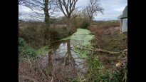
The route starts by working its way out of Leominster along quiet streets among attractive buildings, including Leominster Priory (photo one). The route follows the Herefordshire Trail (HT) across the low-lying land of the Lugg floodplain to reach the B4361 at The Broad, via a woodyard where the HT loses obvious waymarks and walkers should exercise care to follow a safe route past buildings and moving machinery (photo two).
Once across the B4361 the route soon short cuts to Luston along a lane and across fields, off the line of the HT. The route rejoins that of the HT in the centre of Luston and soon encounters a recurrent problem found on Herefordshire PROWs that cross arable fields, i.e. no rolled path and ploughing right up to the hedge line (photo three). Negotiating the obstacle of the arable field, the route crosses the Manchester <> Cardiff railway line (photo four) to arrive at the small village of Eye. Eye Manor (photos five and six) was once the home of the hospitable and creative Sandford family, including Jeremy, author of "Cathy Come Home". Eye Manor is now one of several homes owned by Robert Jenrick, MP for Newark at the time of writing this review (February, 2024).
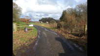
After a short section of road walking between Eye and Moreton the route continues along the HT along the flank of Shuttocks Hill, a distinct ridge of moraine marking the maximum extent of the Wye piedmont glacier during the Devensian ice advance (photo seven). The route crosses the Manchester <> Cardiff railway line again and then another arable field crossing leads to the sad remains of the largely forgotten Kington, Leominster and Stourport canal (photo eight). Soon after, the route passes through the village of Orleton, passing alongside the Boot Inn (photo nine) and exiting the pub car park's left hand corner into an unassuming and unmarked PROW along a narrow alley (far left of photo ten). After doglegging through a residential area the route crosses a small stream, turns right and follows the brook's left bank past a sports ground and into a wood before branching left to cross a ditch to access a diagonal crossing of a large field to emerge onto the B4362 on the western edge of Comberton; careful attention to map reading is needed to find the diagonal path across the large field, although there is a nearby alternative path (not a PROW) continuing beside the brook that links up to the Herefordshire Trail (HT). The route follows the HT past Bilbury, with views opening eastwards to Woofferton long wave radio masts and the Clee Hills beyond (photo eleven). The HT is straightforward to follow onwards past Bury and into Richards Castle before following the B4361 north, over a brook and into Shropshire. Note that at the time of writing (February 2024) the Castle Inn does not appear to be open as a pub; at the Castle Inn, the route separates from that of the HT. Right then left along lanes leads to the higher ground, good views and easy walking along the no through road past Mitnell.
The next mile beyond the end of the no through road contains the most difficult navigation on this route. There may be some confusion over signage on arriving at the end of the surfaced lane at the start of the private drive to Burnt House Farm (photo twelve). Slow Way walkers should ignore the blue way mark to the left and the private drive to Burnt House Farm; instead they should bear right off the surfaced road and follow the unsigned PROW parallel to the hedge line that runs directly towards the buildings of Burnt House Farm. The route passes between the barns on its left and the farmhouse on its right and then follows a hedge line and ridge crest to join the surfaced lane heading for Wheat Common. A new kissing gate atop the left hand bank in Wheat Common leads into a field across which the PROW descends to enter an area of land management on which I will not pass judgement here. Careful navigation is needed with little signage and some awkward boundary crossings; the route is passable and affords views of the frontage of Moor Park school (photo thirteen). After passing through a wooded dingle the route continues along a straight farm track into Overton.
After turning left alongside the B4361 through Overton, the next PROW fingerpost is smothered by ivy but the route turns right off the B4361 and ascends the drive towards Overton House, crosses another drive and then continues as a path that contours across the slope before passing all-too-rare informative signage (photo fourteen) and descending gently to Mabbits Horn and the B4361 towards Ludford.
At the 30 mph signs for Ludford, the route turns right off the main road and passes suburbanised houses and gardens before looping back into Ludford (photo fifteen), crossing Ludford Bridge over the River Teme and ascending Mill Street through the ancient gateway and on into Ludlow town centre.
-
J Mitchell
27 Mar 2024Love your diplomatic comment "land management on which I will not pass judgement here." Having traversed it yesterday, I know what you mean!
-
Nichowes
27 Mar 2024Ha ha! Assume ostriches left you alone.
-
J Mitchell
28 Mar 2024Turns out they're rheas (a kind of emu) and yes, they left us alone - but we didn't turn our backs on them!
-
Share your thoughts
Share your views about this route, give it a star rating, indicate whether it should be verified or not.
Include information that will be useful to others considering to walk or wheel it.
You can add up to 15 photos.
Other Routes for Leominster—Ludlow See all Slow Ways
Review this better route and help establish a trusted network of walking routes.
Suggest a better route if it better meets our methodology.
Share your thoughts