Kingswinford — Brierley Hill
Kinbri one

Slow Way not verified yet. Verify Kinbri here.
Slow Way not verified yet. Verify Kinbri here.
By a Slow Ways Volunteer on 07 Apr 2021
Description
This is a Slow Ways route connecting Kingswinford and Brierley Hill.
Know of a better route? Share it here.
This is a Slow Ways route connecting Kingswinford and Brierley Hill.
Know of a better route? Share it here.
Status
This route has been reviewed by 2 people.
There are no issues flagged.
Photos for Kinbri one


Photos of this route will appear when they are added to a review. You can review this route here.
Information
Route status - Live
Reviews - 2
Average rating -
Is this route good enough? - Yes (2)
There are currently no problems reported with this route.
Downloads - 2
Surveys
We are working to build-up a picture of what routes look like. To do that we are asking volunteers to survey routes so that we can communicate features, obstacles and challenges that may make a route desirable or not.
Slow Ways surveyors are asked to complete some basic online training, but they are not vetted. If you are dependent on the survey information being correct in order to complete a route, we recommend that you think critically about the information provided. You may also wish to wait until more than one survey has been completed.
Help people know more about this route by volunteering to submit a survey.
- Complete the survey training.
- Submit a survey for this route.
Geography information system (GIS) data
Total length
Maximum elevation
Minimum elevation
Start and end points
Kingswinford
Grid Ref
SO8861388839
Lat / Lon
52.49735° / -2.16915°
Easting / Northing
388,613E / 288,839N
What3Words
pushes.marinated.ultra
Brierley Hill
Grid Ref
SO9187087150
Lat / Lon
52.48222° / -2.12114°
Easting / Northing
391,870E / 287,150N
What3Words
affair.taken.agenda
Kinbri One's land is
| Kingswinford | |
|---|---|
| Grid Ref | SO8861388839 |
| Lat / Lon | 52.49735° / -2.16915° |
| Easting / Northing | 388,613E / 288,839N |
| What3Words | pushes.marinated.ultra |
| Brierley Hill | |
|---|---|
| Grid Ref | SO9187087150 |
| Lat / Lon | 52.48222° / -2.12114° |
| Easting / Northing | 391,870E / 287,150N |
| What3Words | affair.taken.agenda |
| Green urban | 9.3% |
| Urban | 90.7% |
Data: Corine Land Cover (CLC) 2018
reviews
Dave4
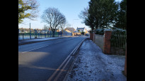
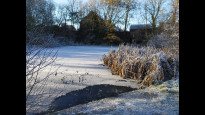
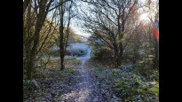
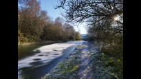
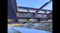
17 Dec 2022A straightforward, easy to follow route. Mostly via pavemented roads but with a middle stretch of parkland and canal towpath. No issues, although steps at some points would probably preclude wheelchairs, buggies etc.
David Sanderson
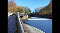
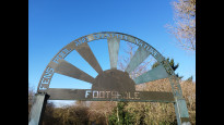
11 Dec 2022Very easy route to walk. Mainly pavement but goes through Buckpool Nature Reserve along the Stourbridge Canalin the middle, so boots are advised. There are steps up out of the park at Kingswinford and over the bridge out of the Nature Reserve so not accessible to all. Easy to follow, safe and direct.
-
Share your thoughts
Share your views about this route, give it a star rating, indicate whether it should be verified or not.
Include information that will be useful to others considering to walk or wheel it.
You can add up to 15 photos.
There are no other routes for Kingswinford — Brierley Hill
If you know a better way, then please let us know.
Review this better route and help establish a trusted network of walking routes.
Suggest a better route if it better meets our methodology.
Share your thoughts