Description
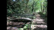
The route starts by following the route of the old railway out of Kimberley before heading north to join the Robin Hood Way at Bulwell Wood. Continues on Robin Hood Way through Bulwell Hall Park, and Bestwood Country Park (including Mill Lakes) before leaving it at Violet Hill to take small paths into Arnold
The route starts by following the route of the old railway out of Kimberley before heading north to join the Robin Hood Way at Bulwell Wood. Continues on Robin Hood Way through Bulwell Hall Park, and Bestwood Country Park (including Mill Lakes) before leaving it at Violet Hill to take small paths into Arnold
Status
This route has been reviewed by 1 person.
There are no issues flagged.
Photos for Kimarn one


Photos of this route will appear when they are added to a review. You can review this route here.
Information

Route status - Live
Reviews - 1
Average rating -
Is this route good enough? - Yes (1)
There are currently no problems reported with this route.
Downloads - 2
Surveys
We are working to build-up a picture of what routes look like. To do that we are asking volunteers to survey routes so that we can communicate features, obstacles and challenges that may make a route desirable or not.
Slow Ways surveyors are asked to complete some basic online training, but they are not vetted. If you are dependent on the survey information being correct in order to complete a route, we recommend that you think critically about the information provided. You may also wish to wait until more than one survey has been completed.
Help people know more about this route by volunteering to submit a survey.
- Complete the survey training.
- Submit a survey for this route.
Geography information system (GIS) data
Total length
Maximum elevation
Minimum elevation
Start and end points
Kimberley
Grid Ref
SK4994944748
Lat / Lon
52.99775° / -1.25722°
Easting / Northing
449,949E / 344,748N
What3Words
rotate.began.audit
Arnold
Grid Ref
SK5859745370
Lat / Lon
53.00247° / -1.12827°
Easting / Northing
458,597E / 345,370N
What3Words
broad.taker.under
| Kimberley | |
|---|---|
| Grid Ref | SK4994944748 |
| Lat / Lon | 52.99775° / -1.25722° |
| Easting / Northing | 449,949E / 344,748N |
| What3Words | rotate.began.audit |
| Arnold | |
|---|---|
| Grid Ref | SK5859745370 |
| Lat / Lon | 53.00247° / -1.12827° |
| Easting / Northing | 458,597E / 345,370N |
| What3Words | broad.taker.under |
Sorry Land Cover data is not currently available for this route. Please check back later.
review
Ken
11 Oct 2021I walked Kimberley to Arnold on a fine day. The route is well plotted except for the start from Kimberley, there is no link from the FP bridge to the path along the old railway. No stiles and no cattle. Safe major road crossing. A fair amount of surfaced path. Some horses around Bestwood Country Park perhaps because it was Sunday. This route does however use much of Kimhuc and Hucarn so I offer a more direct route Kimarn2
The exit from Kimberley may be of interest to railway buffs and nature lovers but the steps could prove a challenge for others so it may be worth considering a detour up Newdigate Street and join the route later. From here the path has been pleasantly integrated into the development rather than fenced in along a separate path.
This is a cycle route which links to Kimarn2 which I have uploaded. Noise from traffic becomes intrusive but underfoot the path is good and well used. After the motorway bridge the path enters fields then a hedged section which retains views across the fields.
From Woodhall Farm the path is a tarmac road to the farm and fishing pond so there is light traffic. An excellent track goes off to the left but typically it fails to offer a route for us. Our path is trapped between fences and hedges although it is possible to roam up that that nice wide track but I didn't say that. Oh what wonderful planners we have, if only walkers could plan the path network.
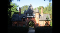
Another right to roam into a nicely mown area, like most folk I gave the kissing gate and overgrown path a miss to walk along the opposite side of the hedge. Next is the sad site of Bulwell Hall where there are plans to obtain a grant to interpret the site, is is worth it I ask? The golf Club House appears to be open to all for beer and coffee so a good half way point.
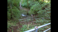
A big Sunday Market was in full swing as I approached the A611 then over the tram and Robin Hood lines but no stops here. I made a detour at Bestwood Country Park and passed to the east of the lake avoiding a climb and perhaps a slightly shorter route. Next came horses but all very docile so no worries. I was hoping for a lunch bench but didn't find one and pressed on.
The path from Violet Hill passing New Farm is hedged in and rather a drag before the final tedious approach into Arnold. There are numerous options to amend this route which I feel could improve it but on the whole this is a good leisure walk between Kimberley and Arnold. I offer a very different more direct route in Kimarn2.
Share your views about this route, give it a star rating, indicate whether it should be verified or not.
Include information that will be useful to others considering to walk or wheel it.
You can add up to 15 photos.
Other Routes for Kimberley—Arnold See all Slow Ways
Review this better route and help establish a trusted network of walking routes.
Suggest a better route if it better meets our methodology.
Share your thoughts