Irthlingborough — Raunds
Irtrau two

Slow Way not verified yet. Verify Irtrau here.
Slow Way not verified yet. Verify Irtrau here.
By Selena Ibbott on 21 Aug 2022
Description
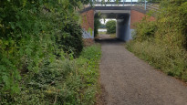
This route follows a lot of the original route but avoids crossing the road by using the underpass. It is mostly countryside and takes you through Standwick lakes where you will find a cafe and toilets. Great for a pit stop
This route follows a lot of the original route but avoids crossing the road by using the underpass. It is mostly countryside and takes you through Standwick lakes where you will find a cafe and toilets. Great for a pit stop
Status
This route has been reviewed by 1 person.
There are no issues flagged.
Photos for Irtrau two


Photos of this route will appear when they are added to a review. You can review this route here.
Information
Route status - Live
Reviews - 1
Average rating -
Is this route good enough? - Yes (1)
There are currently no problems reported with this route.
Downloads - 1
Surveys
We are working to build-up a picture of what routes look like. To do that we are asking volunteers to survey routes so that we can communicate features, obstacles and challenges that may make a route desirable or not.
Slow Ways surveyors are asked to complete some basic online training, but they are not vetted. If you are dependent on the survey information being correct in order to complete a route, we recommend that you think critically about the information provided. You may also wish to wait until more than one survey has been completed.
Help people know more about this route by volunteering to submit a survey.
- Complete the survey training.
- Submit a survey for this route.
Geography information system (GIS) data
Total length
Maximum elevation
Minimum elevation
Start and end points
Irthlingborough
Grid Ref
SP9472670735
Lat / Lon
52.32656° / -0.61145°
Easting / Northing
494,726E / 270,735N
What3Words
leader.upward.electrode
Raunds
Grid Ref
SP9976972844
Lat / Lon
52.34462° / -0.53685°
Easting / Northing
499,769E / 272,844N
What3Words
supposed.loopholes.pleasing
| Irthlingborough | |
|---|---|
| Grid Ref | SP9472670735 |
| Lat / Lon | 52.32656° / -0.61145° |
| Easting / Northing | 494,726E / 270,735N |
| What3Words | leader.upward.electrode |
| Raunds | |
|---|---|
| Grid Ref | SP9976972844 |
| Lat / Lon | 52.34462° / -0.53685° |
| Easting / Northing | 499,769E / 272,844N |
| What3Words | supposed.loopholes.pleasing |
Sorry Land Cover data is not currently available for this route. Please check back later.
There are no other routes for Irthlingborough — Raunds
If you know a better way, then please let us know.
Review this better route and help establish a trusted network of walking routes.
Suggest a better route if it better meets our methodology.