Description
This is a more scenic route using the towpath of the River Lea
This is a more scenic route using the towpath of the River Lea
Status
This route has been reviewed by 6 people.
There are no issues flagged.
Photos for Herwar two


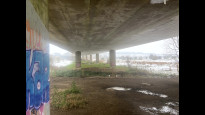


Photos of this route will appear when they are added to a review. You can review this route here.
Information
")
Route status - Live
Reviews - 6
Average rating -
Is this route good enough? - Yes (6)
There are currently no problems reported with this route.
Downloads - 8
Surveys
What is this route like?
Surveys are submitted by fellow users of this website and show what you might expect from this Slow Ways route. Scroll down the page to read more detailed surveys.
| Grade 1X based on 1 surveys | Sign up or log in to survey this route. | ||
|---|---|---|---|
| Description | Note | ||
| Grade 1: Entirely smooth and compacted surfaces. Access grade X: At least one stile, flight of steps or other obstacle that is highly likely to block access for wheelchair and scooter users. |
Grading is based on average scores by surveyors. This slow way has 1 surveys. | ||
| Full grading description | |||
Only people who have completed our training can become Slow Ways surveyors and submit a survey. We do not vet contributors, so we cannot guarantee the quality or completeness of the surveys they complete. If you are dependent on the information being correct we recommend reading and comparing surveys before setting off.
Survey Photos
Facilities
Facilities in the middle third of this route.
Challenges
Potential challenges reported on this route. Some challenges are seasonal.
Obstacles
Obstacles on this route.
Accessibility
Is this route step and stile free?
Measurements
Surveyors were asked to measure the narrowest and steepest parts of paths.
Narrowest part of path: no data
The steepest uphill gradient East: no data
The steepest uphill gradient West: no data
The steepest camber: no data
We don't have clear data on the waymarking (1)
Successfully completed
We asked route surveyors "Have you successfully completed this route with any of the following? If so, would you recommend it to someone with the same requirements?". Here is how they replied.
Recommended by an expert
We asked route surveyors "Are you a trained access professional, officer or expert? If so, is this route suitable for someone travelling with any of the following?" Here is how they replied.
Terrain
We asked route surveyors to estimate how much of the route goes through different kinds of terrain.
There is no data on how much of this route is on roads
There is no data on how much of this route is lit at night
Thereis no data on amount of route paved
There is no data on muddiness
There is no data on rough ground
There is no data on long grass
Report a problem with this data
1 surveys
Information from verified surveys.
Geography information system (GIS) data
Total length
Maximum elevation
Minimum elevation
Start and end points
Hertford
Grid Ref
TL3297012917
Lat / Lon
51.79910° / -0.07306°
Easting / Northing
532,970E / 212,917N
What3Words
await.bend.march
Ware
Grid Ref
TL3600013998
Lat / Lon
51.80809° / -0.02872°
Easting / Northing
536,000E / 213,998N
What3Words
launch.items.mime
| Hertford | |
|---|---|
| Grid Ref | TL3297012917 |
| Lat / Lon | 51.79910° / -0.07306° |
| Easting / Northing | 532,970E / 212,917N |
| What3Words | await.bend.march |
| Ware | |
|---|---|
| Grid Ref | TL3600013998 |
| Lat / Lon | 51.80809° / -0.02872° |
| Easting / Northing | 536,000E / 213,998N |
| What3Words | launch.items.mime |
Sorry Land Cover data is not currently available for this route. Please check back later.
reviews
Strider
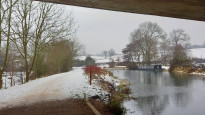
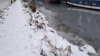
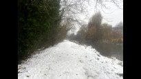
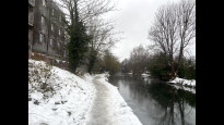
20 Dec 2022We walked this route from Ware to Hertford in the snow and ice.
A bit slippery in places (icy and wet) but still a beautiful, direct and enjoyable walk.
Small temporary diversion around some works, easily navigated.
Even better in sunny weather I would think.
Mtormey
18 Dec 2022I walked this route from Ware to Hertord in December 2022, a few days after the big snowstorm. It was icy and slippery, but even still, easy to follow and a joy to walk.
90% of the route is along the path along the Lee. It's lovely, quick, flat, and super pleasant. A goregous route. Excellent!.
-
Share your thoughts
Jimmyfatwing
26 Oct 2021Nice simple route between Ware and Hertford. Plenty of facilities at either end for food/drink. We’ll maintained footpaths mostly. Can be busy with runners; cyclists and walkers.
-
Share your thoughts
Cpwhitehead
26 Oct 2021Lovely route between Hertford & Ware. A mix of paved and hard packed surface so a little bumpy in places for strollers with small/hard wheels.
-
Share your thoughts
John D Bevan
20 Jun 2021Probably the fastest Slow Ways route between Hertford and Ware, but busy at time with cyclists and well as pedestrians.
-
Share your thoughts
IU3A
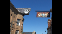
17 Jun 2021If you are starting from the town centre, then pick up landmarks such as the Green Dragon Hotel: Photo 1
Or turn right, down the pedestrianised high street: Photo 2
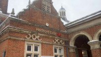
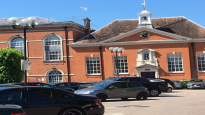
Follow the signs toward the station (Hertford East) but turn left into Christ hospital (Bluecoats school): Photo 3
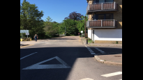
Walk through exiting top right corner. Turn left and walk past in front of Hertford East station. Or if you are starting from the station, come out of main entrance and turn right. At the corner go straight on: Photo 4
Then immediately at the bridge over the canal take the ramp down on the left to the canal path. The path here is tarmaced, about 1.0m wide with some uneven patches (tree root undulations). Photo 5
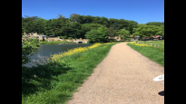
The canal path leads to open country and passed the start of the ‘New River’: Photo 6
As you reach Ware the way narrows but is still very picturesque: Photo 7
You can leave the canal as you approach Ware – route ‘Hewar 3. Or there is an alternative end at Ware (see Hewar 2): You can follow the canal right to the centre, a main road over a bridge. Leave the canal path turn right down the road for 20m then turn left up to Ware rail station.
-
Share your thoughts
Share your views about this route, give it a star rating, indicate whether it should be verified or not.
Include information that will be useful to others considering to walk or wheel it.
You can add up to 15 photos.
Other Routes for Hertford—Ware See all Slow Ways
Review this better route and help establish a trusted network of walking routes.
Suggest a better route if it better meets our methodology.
Share your thoughts