Grantshouse — Eyemouth
Graeye one

Slow Way not verified yet. Verify Graeye here.
Slow Way not verified yet. Verify Graeye here.
By a Slow Ways Volunteer on 07 Apr 2021
Description
This is a Slow Ways route connecting Grantshouse and Eyemouth.
Know of a better route? Share it here.
This is a Slow Ways route connecting Grantshouse and Eyemouth.
Know of a better route? Share it here.
Status
This route has been reviewed by 1 person.
This route has been flagged (1 times) for reasons relating to safety.
Photos for Graeye one


Photos of this route will appear when they are added to a review. You can review this route here.
Information
Route status - Live
Reviews - 1
Average rating -
Is this route good enough? - No (1)
Problems reported - Safety (1)
Downloads - 4
Surveys
We are working to build-up a picture of what routes look like. To do that we are asking volunteers to survey routes so that we can communicate features, obstacles and challenges that may make a route desirable or not.
Slow Ways surveyors are asked to complete some basic online training, but they are not vetted. If you are dependent on the survey information being correct in order to complete a route, we recommend that you think critically about the information provided. You may also wish to wait until more than one survey has been completed.
Help people know more about this route by volunteering to submit a survey.
- Complete the survey training.
- Submit a survey for this route.
Geography information system (GIS) data
Total length
Maximum elevation
Minimum elevation
Start and end points
Grantshouse
Grid Ref
NT8104665592
Lat / Lon
55.88310° / -2.30456°
Easting / Northing
381,046E / 665,592N
What3Words
stumble.remarried.insects
Eyemouth
Grid Ref
NT9436064430
Lat / Lon
55.87300° / -2.09171°
Easting / Northing
394,360E / 664,430N
What3Words
crunches.toolkit.employer
Graeye One's land is
| Grantshouse | |
|---|---|
| Grid Ref | NT8104665592 |
| Lat / Lon | 55.88310° / -2.30456° |
| Easting / Northing | 381,046E / 665,592N |
| What3Words | stumble.remarried.insects |
| Eyemouth | |
|---|---|
| Grid Ref | NT9436064430 |
| Lat / Lon | 55.87300° / -2.09171° |
| Easting / Northing | 394,360E / 664,430N |
| What3Words | crunches.toolkit.employer |
| Arable | 58.7% |
| Bare rock | 3.0% |
| Pasture | 5.6% |
| Urban | 10.8% |
| Woods | 21.9% |
Data: Corine Land Cover (CLC) 2018
review
Genine Keogh
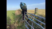
05 Jan 2022My partner and I attempted this route in January as our New Year challenge. Sadly I'd estimate over half this route was inaccessible and unsafe for a few reasons. We are experienced and have done plenty of walking over rough ground and fells but this was a challenge even for us.
The only accessible sections are a few margin field tracks, a couple of minor road sections, then as you enter Coldingham then via the established coastal path back to Eyemouth.
After the first section, we approach a working farm and a field of cows and a bull that was fenced off. Had to take a detour around this. After this, there are multiple gates, fences, barbed wire and electric fences across mainly fields and field margins. The route takes you along a fenceline, appearing as a track on the OS map where it appears there may have previously been a fenced area. There were planted trees down the centre. Sadly this has been overgrown by grass, meaning we had to follow deer tracks through the field. The trees have died leaving mainly plastic tubing :-(
We attempted to take a detour through some heather but this wasn't any easier.
The section through the Grange plantation was dangerous. Drainage ditches to jump and a lot of tree stumps, fallen trees so had to try and find a way out safely to the road.
After this, it was familiar to us and more accessible as we came onto the road that led to Coldingham village. The coastal path is currently muddy, but passable. There is a section that is closed due to a cliff fall with a diversion.
Altogether, a fun challenge to review this route. Looking at the OS Map there may be some alternative off road routes through the windfarm roads to still connect the two places that I'll take a look at and suggest.
Share your views about this route, give it a star rating, indicate whether it should be verified or not.
Include information that will be useful to others considering to walk or wheel it.
You can add up to 15 photos.
There are no other routes for Grantshouse — Eyemouth
If you know a better way, then please let us know.
Review this better route and help establish a trusted network of walking routes.
Suggest a better route if it better meets our methodology.
Share your thoughts