Faringdon — Kingston Bagpuize
Farkin one

Slow Way not verified yet. Verify Farkin here.
Slow Way not verified yet. Verify Farkin here.
By a Slow Ways Volunteer on 07 Apr 2021
Description
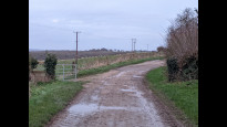
This is a Slow Ways route connecting Faringdon and Kingston Bagpuize.
Know of a better route? Share it here.
This is a Slow Ways route connecting Faringdon and Kingston Bagpuize.
Know of a better route? Share it here.
Status
This route has been reviewed by 2 people.
There are no issues flagged.
Photos for Farkin one


Photos of this route will appear when they are added to a review. You can review this route here.
Information
Route status - Live
Reviews - 2
Average rating -
Is this route good enough? - Yes (2)
There are currently no problems reported with this route.
Downloads - 4
Surveys
What is this route like?
Surveys are submitted by fellow users of this website and show what you might expect from this Slow Ways route. Scroll down the page to read more detailed surveys.
| Grade 4X based on 1 surveys | Sign up or log in to survey this route. | ||
|---|---|---|---|
| Description | Note | ||
| Grade 4: Route includes very rough surfaces including deep ruts, steep loose gravel, unmade paths and deep muddy sections. Wheelchairs may experience traction/wheel spin issues. Access grade X: At least one stile, flight of steps or other obstacle that is highly likely to block access for wheelchair and scooter users. |
Grading is based on average scores by surveyors. This slow way has 1 surveys. | ||
| Full grading description | |||
Only people who have completed our training can become Slow Ways surveyors and submit a survey. We do not vet contributors, so we cannot guarantee the quality or completeness of the surveys they complete. If you are dependent on the information being correct we recommend reading and comparing surveys before setting off.
Survey Photos
Facilities
Facilities in the middle third of this route.
Challenges
Potential challenges reported on this route. Some challenges are seasonal.
Obstacles
Obstacles on this route.
Accessibility
Is this route step and stile free?
Measurements
Surveyors were asked to measure the narrowest and steepest parts of paths.
The narrowest part of the path is 60.0cm (1)
The steepest uphill gradient East: no data
The steepest uphill gradient West: no data
The steepest camber: no data
How clear is the waymarking on the route: Unclear in places (1)
Successfully completed
We asked route surveyors "Have you successfully completed this route with any of the following? If so, would you recommend it to someone with the same requirements?". Here is how they replied.
Recommended by an expert
We asked route surveyors "Are you a trained access professional, officer or expert? If so, is this route suitable for someone travelling with any of the following?" Here is how they replied.
Terrain
We asked route surveyors to estimate how much of the route goes through different kinds of terrain.
20.0% of the route is on roads (1)
10.0% of the route is lit at night (1)
25.0% of the route is paved (1)
20.0% of the route is muddy (1)
20.0% of the route is over rough ground (1)
There is no data on long grass
Report a problem with this data
1 surveys
Information from verified surveys.
Geography information system (GIS) data
Total length
Maximum elevation
Minimum elevation
Start and end points
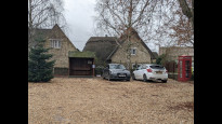
Faringdon
Grid Ref
SU2888395576
Lat / Lon
51.65824° / -1.58384°
Easting / Northing
428,883E / 195,576N
What3Words
quintet.emerald.prefect
Kingston Bagpuize
Grid Ref
SU4070098313
Lat / Lon
51.68211° / -1.41270°
Easting / Northing
440,700E / 198,313N
What3Words
just.desiring.socket
Farkin One's land is
| Faringdon | |
|---|---|
| Grid Ref | SU2888395576 |
| Lat / Lon | 51.65824° / -1.58384° |
| Easting / Northing | 428,883E / 195,576N |
| What3Words | quintet.emerald.prefect |
| Kingston Bagpuize | |
|---|---|
| Grid Ref | SU4070098313 |
| Lat / Lon | 51.68211° / -1.41270° |
| Easting / Northing | 440,700E / 198,313N |
| What3Words | just.desiring.socket |
| Arable | 50.3% |
| Pasture | 16.3% |
| Urban | 27.4% |
| Woods | 6.1% |
Data: Corine Land Cover (CLC) 2018
reviews
Martin McGovern
08 Oct 2023I walked from Kingston Bagpuize to Faringdon.
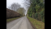
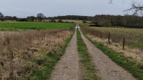
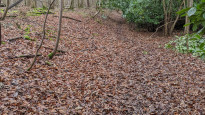
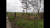
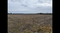
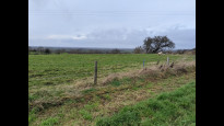
This has a good mix of terrain, although starting from Kingston Bagpuize you might not think so - it's nearly all tarmac until you get through Hinton Waldrist. But after that the off-road elements kick in, with only a few short sections on roads. As the earlier reviewer mentioned, about 100m is on the A420 but easy and safe to handle (the earlier crossing of the A420 just outside Kingston Bagpuize is via a footbridge). The variety of terrain including fields and woodland make this route unsuitable for wheels.
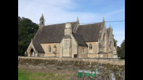
There are pubs and benches in Buckland, and an impressive church which is actually a Catholic chapel built for earlier occupants of Buckland House - the much older village church is nearby. Buckland is just one of a set of villages you pass through, alternating with paths through the countryside. The best views are just to the east of Faringdon.
I encountered only one tricky turn walking west - at grid reference SU318973, the OS map implies that the footpath continues on the northern edge of the field you're in. It doesn't - you need to cross over the stile at that point.
I also have one comment on the accuracy of the route - too small to warrant loading a new one. At Haremoor Farm (SU303964), the route suggests going to the south of the farm buildings. While you can do that, the actual path runs to the north of them.
Juliet Handy
03 Jan 2022Pleasant walk along a mixture of country roads, bridleways, footpaths and through fields. The start and end of the walk (KBS and Faringdon) both have good amenities including pubs, shops and public transport links. A short 100m section is on the verge of the A420, but we found it to be wide and passable. A couple of nice benches in Buckland make for a pleasant stop for a packed lunch.
-
Share your thoughts
Share your views about this route, give it a star rating, indicate whether it should be verified or not.
Include information that will be useful to others considering to walk or wheel it.
You can add up to 15 photos.
There are no other routes for Faringdon — Kingston Bagpuize
If you know a better way, then please let us know.
Review this better route and help establish a trusted network of walking routes.
Suggest a better route if it better meets our methodology.
Share your thoughts