Craven Arms — Church Stretton
Crachu one

Verified Slow Way
Verified by 100.00% of reviewers
Verified Slow Way
Verified by 100.00% of reviewers
By a Slow Ways Volunteer on 07 Apr 2021
Description
This is a Slow Ways route connecting Craven Arms and Church Stretton.
Know of a better route? Share it here.
This is a Slow Ways route connecting Craven Arms and Church Stretton.
Know of a better route? Share it here.
Status
This route has been reviewed by 4 people.
There are no issues flagged.
Photos for Crachu one


Photos of this route will appear when they are added to a review. You can review this route here.
Information
Route status - Live
Reviews - 4
Average rating -
Is this route good enough? - Yes (4)
There are currently no problems reported with this route.
Downloads - 13
Surveys
We are working to build-up a picture of what routes look like. To do that we are asking volunteers to survey routes so that we can communicate features, obstacles and challenges that may make a route desirable or not.
Slow Ways surveyors are asked to complete some basic online training, but they are not vetted. If you are dependent on the survey information being correct in order to complete a route, we recommend that you think critically about the information provided. You may also wish to wait until more than one survey has been completed.
Help people know more about this route by volunteering to submit a survey.
- Complete the survey training.
- Submit a survey for this route.
Geography information system (GIS) data
Total length
Maximum elevation
Minimum elevation
Start and end points
Craven Arms
Grid Ref
SO4318883061
Lat / Lon
52.44256° / -2.83723°
Easting / Northing
343,188E / 283,061N
What3Words
bulldozer.functions.transcribes
Church Stretton
Grid Ref
SO4559193608
Lat / Lon
52.53762° / -2.80361°
Easting / Northing
345,591E / 293,608N
What3Words
duck.belly.connector
Crachu One's land is
| Craven Arms | |
|---|---|
| Grid Ref | SO4318883061 |
| Lat / Lon | 52.44256° / -2.83723° |
| Easting / Northing | 343,188E / 283,061N |
| What3Words | bulldozer.functions.transcribes |
| Church Stretton | |
|---|---|
| Grid Ref | SO4559193608 |
| Lat / Lon | 52.53762° / -2.80361° |
| Easting / Northing | 345,591E / 293,608N |
| What3Words | duck.belly.connector |
| Arable | 22.2% |
| Natural grass | 11.0% |
| Pasture | 44.4% |
| Urban | 16.2% |
| Woods | 6.3% |
Data: Corine Land Cover (CLC) 2018
reviews
J Mitchell
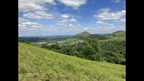
31 Mar 2024Lots of nice stuff: top of Ragleth Hill look out at Wenlock Edge. The bridleway, fields, hollow ways and lanes before getting to Marshbrook; the back of Marshbrook village; the rise up to the top of the hill after Marshbrook where an old drover's way goes past a spring (boggy); architectural and horticultural clues to a previous country estate just before Craven Arms; The Church at Halford.
Liked the up and down varied route and walking through or past oaks, some 100s of years old.
J Walker
31 Mar 2024Great walk, as you might expect in this part of Shropshire. Stunning views from the top of Ragleth. Route was mostly well marked. Pub half-way at Marshbrook a good place to stop for a pint. Particularly enjoyed the back route into Craven Arms along the river through what appeared to be old estate grounds, Halford is an interesting old hamlet too.
-
Share your thoughts
C Hanson
29 Mar 2024We completed this stage on a beautiful cold frosty day in early spring. The ground was still saturated from recent rain so there were a few muddy paths and occasional flooded styles/gates but all were passable. It’s a wonderful route taking in some incredibly beautiful scenery.
Crossing the A49 at the start of the walk in Church Stretton is no problem, there’s a pedestrian crossing by the garage. The route through the town up Ragleth hill is easy to navigate. There are staggering views along the top of Ragleth and a steep slope down the other side which could be difficult in wetter conditions.
The path dips down to almost meet the A49 and then rises through woods. As you rise, look out for the style and footpath sign on your right - we all managed to miss it and had to back track - this leads you down to a footbridge. From here the path rises through the wood to open fields. The path is well signed from here through Oakwood and down to meet the A49. This second crossing of the A49 at Marshbrook is very tricky - take care. We stopped for a drink at the pub here.
The next stage of the walk is fairly straightforward - coinciding at times with the Roman road - and following what appears to be a drovers route alongside a spring. Again there are some fabulous views. There's a lane from the village of Wettles onward and a clearly marked left turn from Lower Lane through a farm yard, then left again along the edges of fields over the railway track and back over the A49 - again, care needed.
The route then takes you through the village of Strefford. Follow the lane as it curves right and through the gate and follow the course of the Quinny Brook. After crossing the footbridge to your left look out for another to the right, cross that and continue following the course of the Quinny. The path takes you through a woodland and open fields before you pass through the hamlet of Halford, the church here has a beautiful churchyard with views over Craven Arms.
-
Share your thoughts
Jack and Siobhan
15 Jun 2022Overall a great Slow Way and a lovely walk. All paths existed and were navigable, and the route was fairly direct between Church Stretton and Craven Arms with minimal time spent on roads.
Leaving Church Stretton there is some time spent on roads, including one busy crossing, to get out of town but you are soon into countryside. As you leave the town there are some small differences between the paths marked on the map and the paths on the ground, but it is easy to see the right way.
The first third of the walk is along the ridge of a hill with beautiful views over the valley. However the way down off the hill is very steep on loose steps which can be quite slippery, and could be difficult in wet weather.
The rest of the walk is straightforwardly along the valley. Some paths are narrow and underused so expect a few nettle stings, but there is nothing that is hidden or too difficult to pass. Twice on the walk you have to cross the busy A49, with no pedestrian crossings or traffic lights to help. There is a pub with a (quite fancy) restaurant for a break around halfway at Marshbrook.
Overall this was a great walk that was easy to navigate and enjoyable to travel. We have given 4 stars rather than 5 due to the steep hill and two busy road crossings.
-
Share your thoughts
Share your views about this route, give it a star rating, indicate whether it should be verified or not.
Include information that will be useful to others considering to walk or wheel it.
You can add up to 15 photos.
There are no other routes for Craven Arms — Church Stretton
If you know a better way, then please let us know.
Review this better route and help establish a trusted network of walking routes.
Suggest a better route if it better meets our methodology.
Share your thoughts