Cotgrave — Melton Mowbray
Cotmel one

Slow Way not verified yet. Verify Cotmel here.
Slow Way not verified yet. Verify Cotmel here.
By a Slow Ways Volunteer on 07 Apr 2021
Description
This is a Slow Ways route connecting Cotgrave and Melton Mowbray.
Know of a better route? Share it here.
This is a Slow Ways route connecting Cotgrave and Melton Mowbray.
Know of a better route? Share it here.
Status
This route has been reviewed by 1 person.
There are no issues flagged.
Photos for Cotmel one


Photos of this route will appear when they are added to a review. You can review this route here.
Information
Route status - Live
Reviews - 1
Average rating -
Is this route good enough? - Yes (1)
There are currently no problems reported with this route.
Downloads - 2
Surveys
What is this route like?
Surveys are submitted by fellow users of this website and show what you might expect from this Slow Ways route. Scroll down the page to read more detailed surveys.
| Grade 0U based on 0 surveys | Sign up or log in to survey this route. | ||
|---|---|---|---|
| Description | Note | ||
| Currently ungraded. Access grade U: Currently ungraded. |
Grading is based on average scores by surveyors. This slow way has 0 surveys. | ||
| Full grading description | |||
Only people who have completed our training can become Slow Ways surveyors and submit a survey. We do not vet contributors, so we cannot guarantee the quality or completeness of the surveys they complete. If you are dependent on the information being correct we recommend reading and comparing surveys before setting off.
Survey Photos

We are working to build-up a picture of what routes look like. To do that we are asking volunteers to survey routes so that we can communicate features, obstacles and challenges that may make a route desirable or not.
Slow Ways surveyors are asked to complete some basic online training, but they are not vetted. If you are dependent on the survey information being correct in order to complete a route, we recommend that you think critically about the information provided. You may also wish to wait until more than one survey has been completed.
Help people know more about this route by volunteering to submit a survey.
- Complete the survey training.
- Submit a survey for this route.
Geography information system (GIS) data
Total length
Maximum elevation
Minimum elevation
Start and end points
Cotgrave
Grid Ref
SK6445335366
Lat / Lon
52.91189° / -1.04301°
Easting / Northing
464,453E / 335,366N
What3Words
nights.bandwagon.violinist
Melton Mowbray
Grid Ref
SK7527519116
Lat / Lon
52.76443° / -0.88585°
Easting / Northing
475,275E / 319,116N
What3Words
liner.pulse.libraries
Cotmel One's land is
| Cotgrave | |
|---|---|
| Grid Ref | SK6445335366 |
| Lat / Lon | 52.91189° / -1.04301° |
| Easting / Northing | 464,453E / 335,366N |
| What3Words | nights.bandwagon.violinist |
| Melton Mowbray | |
|---|---|
| Grid Ref | SK7527519116 |
| Lat / Lon | 52.76443° / -0.88585° |
| Easting / Northing | 475,275E / 319,116N |
| What3Words | liner.pulse.libraries |
| Arable | 51.7% |
| Pasture | 30.2% |
| Urban | 16.6% |
| Woods | 1.5% |
Data: Corine Land Cover (CLC) 2018
review
Hugh Hudson
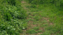
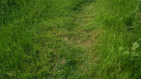
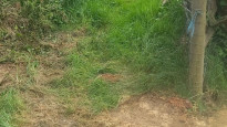
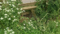
29 May 2022 (edited 16 Nov 2022)This is a long and fairly challenging route. The canal and road parts are easy, but the path between Hickling and Nether Broughton has a lot of stiles, many of which are surrounded by nettles and could cause problems for older walkers and those wearing shorts or skirts. There was also one field where finding a route through dense crops was a little awkward. The route into Melton also has a few awkward high stiles requiring long legs, and the hill between Nether Broughton and Wartnaby is quite steep and overgrown in places. The route out of Cotgrave into the wood cannot be followed exactly because the rights of way on the OS map do not match the footpaths on the ground.
Overall, For fit walkers the route is quite enjoyable.
On reflection, I have decided that the problems with this route are not sufficient to flag it, because it is not at all obvious how to find a better one that does not have similar issues.
Share your views about this route, give it a star rating, indicate whether it should be verified or not.
Include information that will be useful to others considering to walk or wheel it.
You can add up to 15 photos.
There are no other routes for Cotgrave — Melton Mowbray
If you know a better way, then please let us know.
Review this better route and help establish a trusted network of walking routes.
Suggest a better route if it better meets our methodology.
Share your thoughts