Chesterfield — Bolsover
Chebol four

Slow Way not verified yet. Verify Chebol here.
Slow Way not verified yet. Verify Chebol here.
By David Sanderson on 21 Dec 2021
Description
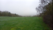
Reasonably direct route from Chesterfield to Bolsover via Calow, Arkwright Town and Long Duckmanton. Mainly footpath, but the 3km section between Long Duckmanton and the westerly edge of Bolsover is on the pavement of the A632. Pubs at 4.24km and 6.41km. Supermarket/petrol station at 7.38km
Reasonably direct route from Chesterfield to Bolsover via Calow, Arkwright Town and Long Duckmanton. Mainly footpath, but the 3km section between Long Duckmanton and the westerly edge of Bolsover is on the pavement of the A632. Pubs at 4.24km and 6.41km. Supermarket/petrol station at 7.38km
Status
This route has been reviewed by 2 people.
There are no issues flagged.
Photos for Chebol four


Photos of this route will appear when they are added to a review. You can review this route here.
Information
Route status - Live
Reviews - 2
Average rating -
Is this route good enough? - Yes (2)
There are currently no problems reported with this route.
Downloads - 3
Surveys
We are working to build-up a picture of what routes look like. To do that we are asking volunteers to survey routes so that we can communicate features, obstacles and challenges that may make a route desirable or not.
Slow Ways surveyors are asked to complete some basic online training, but they are not vetted. If you are dependent on the survey information being correct in order to complete a route, we recommend that you think critically about the information provided. You may also wish to wait until more than one survey has been completed.
Help people know more about this route by volunteering to submit a survey.
- Complete the survey training.
- Submit a survey for this route.
Geography information system (GIS) data
Total length
Maximum elevation
Minimum elevation
Start and end points
Chesterfield
Grid Ref
SK3850071140
Lat / Lon
53.23592° / -1.42464°
Easting / Northing
438,500E / 371,140N
What3Words
silly.shall.hook
Bolsover
Grid Ref
SK4738770498
Lat / Lon
53.22943° / -1.29160°
Easting / Northing
447,387E / 370,498N
What3Words
proclaims.warrior.loitering
| Chesterfield | |
|---|---|
| Grid Ref | SK3850071140 |
| Lat / Lon | 53.23592° / -1.42464° |
| Easting / Northing | 438,500E / 371,140N |
| What3Words | silly.shall.hook |
| Bolsover | |
|---|---|
| Grid Ref | SK4738770498 |
| Lat / Lon | 53.22943° / -1.29160° |
| Easting / Northing | 447,387E / 370,498N |
| What3Words | proclaims.warrior.loitering |
Sorry Land Cover data is not currently available for this route. Please check back later.
reviews
StephenWalker
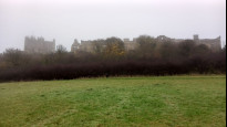
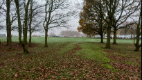
23 Aug 2023 (edited 24 Aug 2023)I walked this route as part of a Chesterfield - Bolsover - Staveley - Chesterfield circular. I started the walk from Chesterfield towards Bolsover. Once clear of the town centre and under the railway, the route climbs steadily through woodland and across a golf course, to reach Calow - which is approached through the grounds of the hospital. There are footpaths through the housing in Calow before we reach open country again near Moor Farm. From here a footpath heads down to and across the landscaped site of Arkwright Colliery - now the location of several solar farms. We reach the Arkwright Arms (refreshments) and follow the pavement alongside the busy A632 through Long Duckmanton. After crossing the M1 bridge a dedicated multi-user path takes us parallel to the road as far as Carr Vale. The final climb to the castle is a thin path through the fields and meadows heading for the right hand (South East) end of the castle frontage. There is a path through the woods to reach the 'Pillar of Rock' pub (more refreshments) and shortly after to reach the Market Place.
I enjoyed this route it is direct and functional. The cross-country footpaths are easily followed and the multi-user trail takes you far enough away from the roadside of the A632 to make a pleasant walk.
Hugh Hudson
30 Nov 2022 (edited 01 Dec 2022)This is a review of CHEBOL 4 - ASCWIN 0 has the same route number, which confuses things.
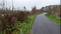
Walked from Bolsover to Chesterfield. A sound route, with a few stiles and field paths. There is a new surfaced track north of the A632 parallel to the route, which is much better than the pavement walk. Elsewhere easy but a little muddy in places.
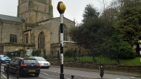
Leaving the meeting point in Bolsover, we go up Market Street and Castle Street, following the round round right in front of the castle. We go steeply down Castle Lane (the pavement has a handrail) then follow the path that goes right under the castle walls. This leads out onto an open field, where the best trodden path goes a little further right than the right of way. The lower field is arable, and the line across it is obvious in late autumn but may be less so in summer, and at the bottom end it goes further left/south than the right of way, and emerges directly opposite the surfaced path that cuts the corner down to the A632 (Station Road). It is best to cross and use the pavement on the north side.
Beyond the roundabout it is worth seeking out the new surfaced path/cycle track (marked on OpenStreetMap) which offers an alternative to the north pavement of the A632, and is shielded by traffic noise by a hedge. This leads directly to the end of Buttermilk Lane on the roundabout. We cross Buttermilk Lane and Markham Lane then find another surfaced path/cycle track that rejoins the A632 pavement just before the M1 bridge. We cross the bridge and continue along the pavement to the junction with Staveley Road where the main road turns left and we take a path up an alleyway behind the war memorial. The trodden path stays on the right/north side of the fences of the hedges (the right of way line is wrong) and fences and crosses a couple of stiles to emerge on a surfaced lane.
We follow this lane round a bend, then take the field path right that leads to an underpass under the old railway track and continues across the field beyond - the trodden line is more direct than the right of way line. At the top of the field we bear right onto Works Lane, which is unsurfaced until the first farm road is reached. We follow the lane to the A632, and follow that a short distance before turning right through a pub car park and following the path into the fields. We turn left to find the lane onto Blacksmith Lane, which we cross to find the alleyway opposite, which crosses Rose Avenue and turns right then left to emerge on Church Lane, where we go right a short distance to find another alleyway left that leads into a car park on Central Drive, where we turn left, then cross North Road and follow the path straight on.
This path follows the field edges to an open park space, which we cross into a large hospital car park, where the footpath is not well marked but the approximate line is obvious. Beyond the access road we cross an open space (no footpath sign) to Sycamore Drive, where the path continues and becomes clearer and eventually rejoins the main road. Almost immediately we turn right onto another signposted footpath which leads out onto a golf course. Beyond the fairway we bear left following footpath signs, and cross the hedge lower down then follow it to what becomes a well marked lane that takes us steeply down to Piccadilly Road.
Here we go left a short distance then right through the houses and across the river Rother, then take the surfaced track right across a park to reach Crow Lane just before the railway bridge (the left fork is more direct). The pavement on Crow Lane is on the north side, so we cross and follow it round to the junction opposite the station. The bridge over the A61 is obvious ahead, and beyond it we turn right up Corporation Street and take the steps up into the churchyard to the Chesterfield meeting point under the twisted spire. These steps can be avoided if necessary by following the roads on either side of the churchyard.
-
Share your thoughts
Share your views about this route, give it a star rating, indicate whether it should be verified or not.
Include information that will be useful to others considering to walk or wheel it.
You can add up to 15 photos.
Other Routes for Chesterfield—Bolsover See all Slow Ways
Review this better route and help establish a trusted network of walking routes.
Suggest a better route if it better meets our methodology.
Share your thoughts