Description
This is a Slow Ways route connecting Burnley and Cliviger.
Know of a better route? Share it here.
This is a Slow Ways route connecting Burnley and Cliviger.
Know of a better route? Share it here.
Status
This route has been reviewed by 2 people.
There are no issues flagged.
Photos for Burcli one


Photos of this route will appear when they are added to a review. You can review this route here.
Information

Route status - Live
Reviews - 2
Average rating -
Is this route good enough? - Yes (2)
There are currently no problems reported with this route.
Downloads - 1
Surveys
What is this route like?
Surveys are submitted by fellow users of this website and show what you might expect from this Slow Ways route. Scroll down the page to read more detailed surveys.
| Grade 2X based on 1 surveys | Sign up or log in to survey this route. | ||
|---|---|---|---|
| Description | Note | ||
| Grade 2: Mostly smooth and compacted surfaces, but there may be some loose gravel, muddy patches or cobbles. Access grade X: At least one stile, flight of steps or other obstacle that is highly likely to block access for wheelchair and scooter users. |
Grading is based on average scores by surveyors. This slow way has 1 surveys. | ||
| Full grading description | |||
Only people who have completed our training can become Slow Ways surveyors and submit a survey. We do not vet contributors, so we cannot guarantee the quality or completeness of the surveys they complete. If you are dependent on the information being correct we recommend reading and comparing surveys before setting off.
Survey Photos
Facilities
Facilities in the middle third of this route.
Challenges
Potential challenges reported on this route. Some challenges are seasonal.
Obstacles
Obstacles on this route.
Accessibility
Is this route step and stile free?
Measurements
Surveyors were asked to measure the narrowest and steepest parts of paths.
The narrowest part of the path is 40.0cm (1)
The steepest uphill gradient walking East 19.0% (1)
The steepest uphill gradient West: no data
The steepest camber: no data
How clear is the waymarking on the route: Clear (1)
Successfully completed
We asked route surveyors "Have you successfully completed this route with any of the following? If so, would you recommend it to someone with the same requirements?". Here is how they replied.
Recommended by an expert
We asked route surveyors "Are you a trained access professional, officer or expert? If so, is this route suitable for someone travelling with any of the following?" Here is how they replied.
Terrain
We asked route surveyors to estimate how much of the route goes through different kinds of terrain.
There is no data on how much of this route is on roads
There is no data on how much of this route is lit at night
Thereis no data on amount of route paved
There is no data on muddiness
There is no data on rough ground
There is no data on long grass
Report a problem with this data
1 surveys
Information from verified surveys.
Geography information system (GIS) data
Total length
Maximum elevation
Minimum elevation
Start and end points
Burnley
Grid Ref
SD8398033052
Lat / Lon
53.79354° / -2.24467°
Easting / Northing
383,980E / 433,052N
What3Words
help.sofa.form
Cliviger
Grid Ref
SD8651629963
Lat / Lon
53.76585° / -2.20603°
Easting / Northing
386,516E / 429,963N
What3Words
crust.hits.fees
Burcli One's land is
| Burnley | |
|---|---|
| Grid Ref | SD8398033052 |
| Lat / Lon | 53.79354° / -2.24467° |
| Easting / Northing | 383,980E / 433,052N |
| What3Words | help.sofa.form |
| Cliviger | |
|---|---|
| Grid Ref | SD8651629963 |
| Lat / Lon | 53.76585° / -2.20603° |
| Easting / Northing | 386,516E / 429,963N |
| What3Words | crust.hits.fees |
| Green urban | 12.2% |
| Pasture | 15.9% |
| Urban | 70.9% |
| Woods | 0.9% |
Data: Corine Land Cover (CLC) 2018
reviews
William Huxham
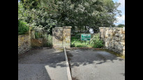
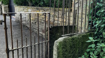
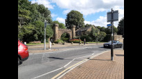
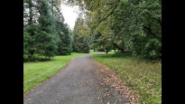
19 Sep 2023The route starts at the top of Park Lane in Cliviger descending passed an interesting History Information Board and new houses on the left. The path enters farmland via an unusual kissing gate with iron attachments and a headroom structure. This stretch of the walk is straight with Townley Hall on the left hand side and local park accessories such as an ice cream van and a children's’ playground.
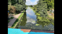
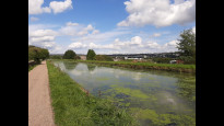
The path goes to the entrance of Townley Hall and after negotiating the busy road via a pedestrian crossing, a stretch of unattractive road with local traffic is walked for almost half a mile. The highlight of the walk is reached as it turns right onto one of the 7 wonders of the Waterways which is the Burnley embankment, 60 feet above the town with views of Turfmoor (Burnley F C) and a church tower both at almost eye level. The Leeds-Liverpool canal had quite a lot of litter in it but also a heron, 2 moorhens and mallards were visible during the mile long stretch. The walk ends with a short stretch through Brun valley finishing at Burnley Central. Unfortunately the pub there is derelict.
Mary Oz
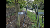
14 Sep 2023This route left Cliviger along a quiet street, and was soon heading into Towneley’s parkland. I’m afraid I was so fascinated by the unique kissing gate, made of flat stones, and ironwork to bump your head on (unless you’re short like me), that I forgot to check how accessible the gate alongside it was.
There followed a compacted earth footpath with a field of horses next to it. This soon turned into a gravelled path through playing fields, and then into a tarmacked path. Just off from this was a children’s playground, a small café, toilets, an ice cream van, and tables. This was less than 30% through the walk.
Eventually we left the park and crossed the road, via a pelican crossing, and headed along a straight, commercial then residential road. It would have helped us if we’d crossed this road before reaching the canal.
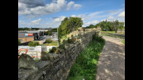
Access to the towpath was via a slightly steep slope on the north side of the road, after crossing the bridge. It’s worth pausing on the bridge to look along the Burnley Embankment that you are about to walk along. This is an extraordinary raised, dead straight section of the Leeds and Liverpool Canal, that is as much as 60 feet above the surrounding land. There were good views of Burnley’s football ground, and of the housing, churches, shops and hills all around. There was stone seating set into the wall.
https://canalrivertrust.org.uk/enjoy-the-waterways/canal-history/history-features-and-articles/the-seven-wonders-of-the-waterways
After the embankment, the route continued on the towpath right round to the far side of Thompson Park, and up a slope into Thursby Gardens and on to the station. I think this could have been shortened by entering Thompson Park earlier from the towpath.
Overall this was a very enjoyable route. The Towneley Park section was very direct. Using the Burnley Embankment added almost a mile (35%) onto the route, but for me it was worth it. The more direct alternative, along busy roads and through the shopping centre, would have felt a bit tedious.
-
Share your thoughts
Share your views about this route, give it a star rating, indicate whether it should be verified or not.
Include information that will be useful to others considering to walk or wheel it.
You can add up to 15 photos.
There are no other routes for Burnley — Cliviger
If you know a better way, then please let us know.
Review this better route and help establish a trusted network of walking routes.
Suggest a better route if it better meets our methodology.
Share your thoughts