Description
This is a Slow Ways route connecting Broseley and Codsall.
Know of a better route? Share it here.
This is a Slow Ways route connecting Broseley and Codsall.
Know of a better route? Share it here.
Status
This route has been reviewed by 1 person.
There are no issues flagged.
Photos for Brocod one

Photos of this route will appear when they are added to a review. You can review this route here.
Information

Route status - Live
Reviews - 1
Average rating -
Is this route good enough? - Yes (1)
There are currently no problems reported with this route.
Downloads - 4
Surveys
We are working to build-up a picture of what routes look like. To do that we are asking volunteers to survey routes so that we can communicate features, obstacles and challenges that may make a route desirable or not.
Slow Ways surveyors are asked to complete some basic online training, but they are not vetted. If you are dependent on the survey information being correct in order to complete a route, we recommend that you think critically about the information provided. You may also wish to wait until more than one survey has been completed.
Help people know more about this route by volunteering to submit a survey.
- Complete the survey training.
- Submit a survey for this route.
Geography information system (GIS) data
Total length
Maximum elevation
Minimum elevation
Start and end points
Broseley
Grid Ref
SJ6742001809
Lat / Lon
52.61309° / -2.48260°
Easting / Northing
367,420E / 301,809N
What3Words
jeep.mastering.certified
Codsall
Grid Ref
SJ8643203296
Lat / Lon
52.62727° / -2.20188°
Easting / Northing
386,432E / 303,296N
What3Words
august.guess.remind
Brocod One's land is
| Broseley | |
|---|---|
| Grid Ref | SJ6742001809 |
| Lat / Lon | 52.61309° / -2.48260° |
| Easting / Northing | 367,420E / 301,809N |
| What3Words | jeep.mastering.certified |
| Codsall | |
|---|---|
| Grid Ref | SJ8643203296 |
| Lat / Lon | 52.62727° / -2.20188° |
| Easting / Northing | 386,432E / 303,296N |
| What3Words | august.guess.remind |
| Arable | 55.6% |
| Pasture | 30.5% |
| Urban | 9.0% |
| Woods | 5.0% |
Data: Corine Land Cover (CLC) 2018
review
Eddie Jones
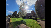
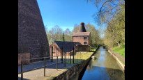
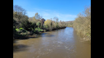
03 Apr 2023Walk of two halves. Both are good but second half is much nicer. Walk from Codsall through Albrighton very road heavy though small section of fields easily followed. Walk from Albrighton to Beckbury on pleasant country lanes, amd Beckbury has a nice community shop that was open when we walked through. Lanes again across to Sutton Maddock to drop to River Severn. Route dramatically changes here. Suddenly surrounded by heritage and wildlife. YHA at Coalport makes a good resting point. Steep climb up a nice stream valley (Corbetts Dingle) to reach Broseley. No access issues and all roads safe to walk along.
Share your views about this route, give it a star rating, indicate whether it should be verified or not.
Include information that will be useful to others considering to walk or wheel it.
You can add up to 15 photos.
There are no other routes for Broseley — Codsall
If you know a better way, then please let us know.
Review this better route and help establish a trusted network of walking routes.
Suggest a better route if it better meets our methodology.
Share your thoughts